
St. Martin (Pfaffenhofen an der Zusam)


St. Martin is the Catholic parish church of Pfaffenhofen an der Zusam , a district of the municipality Buttenwiesen in the district of Dillingen an der Donau , which belongs to the Bavarian administrative district of Swabia . Because of its unusual size and its elevated position, through which it can be seen from afar, the parish church of St. Martin is also known as the Zusamdom .
history
The church is dedicated to St. Martin of Tours , who was especially venerated by the Franks . For this reason, the development of the church and the Pfaffenhofen settlement are traced back to the time of Christianization under Franconian rule. Through a donation from Augsburg Bishop Gebehard (996-1001) Pfaffenhofen came to the Augsburg noble women's monastery St. Stephan , in whose possession it remained until the secularization in 1802/03. Until 1859 and 1861 the two neighboring towns of Unter- and Oberthürheim belonged to the Pfaffenhofen parish . The present church was built in 1722/1724 by the Wessobrunn builder and plasterer Joseph Schmuzer , who also created the monastery churches of Irsee , Ettal and Rottenbuch . In 1739 the church tower was raised.
Pig pilgrimage
Between Pfaffenhofen and Unterthürheim there was a chapel until 1806 , which was dedicated to St. New Year's Eve (died in Rome in 335) and was the destination of a pilgrimage that was celebrated as a Seifest . Sei is both the dialect version for the name Sylvester and for the word sows. Holy New Year's Eve is considered the patron saint of domestic animals and the pilgrimage to Pfaffenhofen was interpreted as a pig pilgrimage . Pig's feet were sacrificed as votive offerings and St. New Year's Eve was venerated as a pig saint . The original pilgrimage was probably aimed at St. Anthony , who is usually depicted with a pig and whose figure stood in the old chapel next to that of St. Sylvester. After the chapel was demolished, the pilgrimage was transferred to the parish church.
architecture
Exterior construction
In the northern corner of the choir is the 57 meter high tower, tapering in three sections, crowned by an onion dome with a lantern . The lower, square floors are still from the 14th century. They are provided with a toothed frieze and, like the upper floors, with corner pilasters . In the upper, octagonal section, the sound openings are designed as twin windows and bass violin windows, which are integrated into fields framed by volutes .
The west facade with the sign laid out over steps is characterized by large glare fields with transverse oval blind window niches. It has a volute gable structured by cornices , which is closed with a segmented arch field . A figural niche and a round window break through the gable in its central axis.
inner space

The church has a single nave . The stucco decor of the church is the work of the Wessobrunn master builder Joseph Schmuzer . The nave has a central flat dome with frescoes by the Dillingen painter Anton Wenzeslaus Haffe , to whom the other frescoes in the church, such as the dome of the choir , are also based. The high altar painting comes from the post-war period . It was created by Franz Klemmer , a student of Hugo von Habermann .
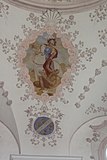
Saint Martin
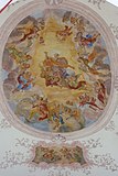
Dome fresco

Stoning of St. Stephen


Furnishing

- In the church there is now the sculpture of St. Sylvester, which used to stand in St. Sylvester's chapel and was the destination of the pilgrimage. It is dated around 1470.
- A late Gothic half-relief depicting the coronation of Mary was created around 1500.
- The four-nail type cross also dates from around 1500 . * The baroque apostles go back to the time the church was built.
- The pulpit was created by Johann Pflaum in 1748.
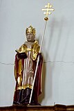
Pope Sylvester
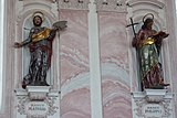
apostle
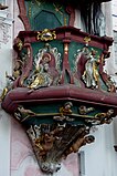
Pulpit


literature
- Georg Dehio: Handbook of the German art monuments. Art monuments Bavaria III: Swabia . (revised by Bruno Bushart and Georg Paula), Deutscher Kunstverlag, Munich 1989, ISBN 3-422-03008-5 , pp. 870–871.
- Georg Wörishofer, Alfred Sigg, Reinhard H. Seitz: Cities, Markets and Communities . In: The district of Dillingen ad Donau in the past and present . 3rd revised edition, Landkreis Dillingen ad Donau (Ed.), Dillingen an der Donau 2005, pp. 195–196.
Web links
Individual evidence
Coordinates: 48 ° 36 ′ 43.4 " N , 10 ° 42 ′ 32.4" E