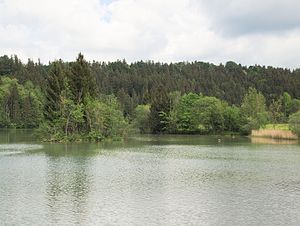
Steep slopes and floodplains of the Lech between Kinsau and Hohenfurch
|
Steep slopes and floodplains of the Lech between Kinsau and Hohenfurch
|
||
|
Floodplain on the Lech near Hohenfurch |
||
| location | Districts of Weilheim-Schongau and Landsberg am Lech in Upper Bavaria | |
| surface | approx. 190 ha | |
| WDPA ID | 329641 | |
| Geographical location | 47 ° 52 ' N , 10 ° 55' E | |
|
|
||
| Setup date | September 30, 2004 | |
| administration | Federal Agency for Nature Conservation | |
| Legal basis | Ordinance 820-8622-13 / 84 | |
The nature reserve Steilhalden and Flussauen des Lech between Kinsau and Hohenfurch is located in the districts of Weilheim-Schongau and Landsberg am Lech in Upper Bavaria .
The 188.3 hectare area with the number NSG-00643.01, which was placed under nature protection in 2004 , extends east of the core town of the municipality of Kinsau and northeast of the core town of the municipality of Hohenfurch along the Lech . The B 17 runs to the west of the area and the St 2014 to the east.
Protection goals
The conservation area is to preserve a section of the Lech Valley with its diverse communities and to secure and promote the function of the Lech Valley as a flora and fauna bridge between the Alps and the Jura . Uninfluenced development should be made possible for natural and near-natural habitats. Sliding slopes are left to their own devices in terms of their movement dynamics and vegetation development, and river relocations are also permitted, provided that this is possible within the framework of the Lech's hydropower use. In order to preserve rare and endangered animal and plant species and to promote their natural development, their feeding, breeding and living spaces are protected and their privacy is guaranteed. Geomorphological changes such as the natural further development of the impact slopes are permitted; The rock outcrops and relief forms as important documents of the geological history of the region are to be preserved for the purposes of popular education and local history as well as science, research and teaching. Scientific research into the area continues.
See also
- List of nature reserves in the Landsberg am Lech district
- List of nature reserves in the Weilheim-Schongau district


