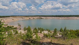
Stiebsdorf
|
Stiebsdorf
City of Luckau
Coordinates: 51 ° 46 ′ 12 " N , 13 ° 47 ′ 36" E
|
|
|---|---|
| Incorporation : | August 6, 1964 |
| Incorporated into: | Princely Drehna |
Stiebsdorf ( Lower Sorbian Sćiwojce ) was a village in Brandenburg that had to give way to the Schlabendorf-Süd open-cast lignite mine between 1981 and 1983 . Stiebsdorf was most recently a district of the former municipality of Fürstlich Drehna , a current district of the city of Luckau in the Dahme-Spreewald district .
location
Stiebsdorf was in Niederlausitz , about two kilometers northwest of Fürstlich Drehna and ten kilometers as the crow flies southeast of the city of Luckau. Surrounding villages were Wanninchen in the north, Pademack in the northeast, Gliechow in the east, Fürstlich Drehna in the southeast, Bergen in the southwest and Beesdau in the northwest.
history
Stiebsdorf was first mentioned in 1486 under the name Stivestorff . The place name is derived from a Slavic personal name, probably from Stibor . The Sorbian place name Sćiwojce probably means honorable fighter . Settlement of the local area of Stiebsdorf can be proven up to the Neolithic Age .
The place used to belong to the Drehna rule . From 1597 it belonged to the noble von Minckwitz family , until 1636 at the latest the place was acquired by Hans Friedrich von Minckwitz together with Wanninchen, who however lost the places Erpitz and Garrenchen . From 1697 the village was owned by the von Promnitz family and from 1807 Stiebsdorf belonged to the Counts of Lynar . A sheep farm was mentioned in the village around 1800 . According to the topographical-statistical overview of the administrative district of Frankfurt ad O. from 1844, Stiebsdorf had 66 inhabitants in 14 residential buildings that year. The village had a Vorwerk and the already aforementioned sheep farm. Stiebsdorf was parish after Fürstlich Drehna. In 1867 the place had 107 inhabitants. In the same year a windmill was also mentioned, it was built in 1864. In 1877 Count Moritz zu Lynar sold the Drehna estate and its associated towns to the Wätjen family from Bremen .
The Vorwerk belonging to Stiebsdorf comprised a total of 482 hectares of land, of which 342 hectares were forest and 140 hectares were arable land. In turn, 80 hectares of the arable land were used by the local farmers for their own cultivation. The village was dominated by agriculture, the residents of Stiebsdorf lived mainly from cattle breeding . In addition, as in many villages in the area, fish farming was carried out. In the vicinity of Stiebsdorf was the "Great Pond", which used to be the largest pond in Lower Lusatia. This was drained in 1893. There was also a brick factory in Stiebsdorf , which was operated until 1917. There were also some gravel pits . The children of the village went to school in Fürstlich Drehna. Until the middle of the 19th century, Stiebsdorf also had Sorbian-speaking residents, 'after which Sorbian slowly disappeared from linguistic usage.
At the Congress of Vienna in 1815, after the defeat of the Kingdom of Saxony, it was decided to assign territory to the Kingdom of Prussia , which also affected the municipality of Stiebsdorf. Since then, the community has belonged to the newly founded district of Luckau in the administrative district of Frankfurt in the Prussian province of Brandenburg . During the GDR district reform on July 25, 1952, the Luckau district was renamed Luckau district and greatly reduced in size, but Stiebsdorf remained part of the district. On August 6, 1964, Stiebsdorf was incorporated into Drehna, today Fürstlich Drehna . The place was part of the Lusatian lignite mining area . In 1975, the opening of the Schlabendorf-Süd opencast mine began, for which Stiebsdorf was planned for demolition. Between 1981 and 1983 the village was devastated , 60 inhabitants were resettled in the surrounding areas. A memorial stone reminds of Stiebsdorf near the old location.
Population development
| Population development in Stiebsdorf from 1875 to 1950 | |||||||||||||
|---|---|---|---|---|---|---|---|---|---|---|---|---|---|
| year | Residents | year | Residents | year | Residents | ||||||||
| 1875 | 74 | 1925 | 97 | 1946 | 81 | ||||||||
| 1890 | 84 | 1933 | 81 | 1950 | 79 | ||||||||
| 1910 | 90 | 1939 | 65 | ||||||||||
See also
Web links
Individual evidence
- ↑ Reinhard E. Fischer : The place names of the states of Brandenburg and Berlin . be.bra Wissenschaft, Berlin 2005, ISBN 978-3-937233-30-7 , p. 164 .
- ↑ Topographical-statistical overview of the administrative district of Frankfurt ad O. 1844, p. 163 ( bsb-muenchen.de ).
- ↑ Statistical Bureau of the Royal Government of Frankfurt a. O .: Topographical-statistical manual of the government district of Frankfurt a. O. Verlag von Gustav Harnecker u. Co., Frankfurt ad O. 1867, online at Google Books , p. 187
- ↑ Gudrun Driesen: In 1981 Stiebsdorf had to give way to the opencast mine. In: lr-online.de. Lausitzer Rundschau , July 5, 2005, accessed on July 1, 2018 .
- ^ Stiebsdorf in the historical index of places. Retrieved July 1, 2018 .
- ↑ Stiebsdorf in the archives disappeared places , accessed on July 1, 2018
- ↑ Historical municipality register of the state of Brandenburg 1875 to 2005. (PDF; 331 kB) District Dahme-Spreewald. State Office for Data Processing and Statistics State of Brandenburg, December 2006, accessed on July 1, 2018 .
