Tegelen
 flag |
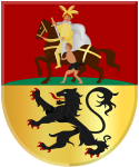
 coat of arms |
| province |
|
| local community |
|
|
Area - land - water |
10.42 km 2 10.08 km 2 0.34 km 2 |
| Residents | 18,945 (Jan. 1, 2018) |
| Coordinates | 51 ° 21 ' N , 6 ° 8' E |
| height | 18 m NAP |
| Important traffic route |
|
| prefix | 077 |
| Postcodes | 5467, 5912, 5915, 5931 |
| Website | Homepage of Tegelen |
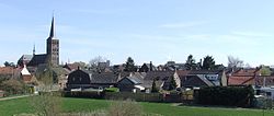
| View from the Maasveld district | |
Tegelen ( Limburgish Tegele ; pronounced: "Teechele (n)" with a soft "ch" on the border with the "j") is a district of the Dutch city of Venlo with 18,945 inhabitants (as of January 1, 2018). The well-known monastery village of Steyl belongs to the Tegelen district . Until 2001, Tegelen was a town and an independent municipality in the Limburg province .
Surname
The name Tegelen is derived from the Latin word tegula , which means "brick" or "roof tile / roof tile". The name was coined due to the extensive clay deposits in the area, which were used for brick kilns and pottery.
A geological epoch was named after Tegelen in the Dutch language , the Tiglien , 2.4 to 1.8 million years ago (the German classification apparently uses different terms, the period roughly corresponds to the Gelasium ). The name goes back to extensive archaeological finds of fossils from this period in the Tegel clay pits.
history
Tegelen was already settled in Roman times. Several Roman pottery and brick kilns have been found during excavations .
The Tegelen Sankt-Martin-Kirche was recorded in church and monastery archives around the year 800. Due to the strategic location on the Meuse , fortified farms and castles were built early on. The most important are the old Munt castle (Dutch: Oude Munt ) and the Holtmühle castle ( Kasteel Holtmühle ), both from the 17th century .
There were many military conflicts in the area in the Middle Ages and in the early modern period, mainly because of the proximity of the important fortress town of Venlo (→ Fort St. Michael ). In the course of time, a barracks was set up in Venlo, and a fort in nearby Blerick (also a part of Venlo today). From these fortifications, especially in the 16th and 18th centuries, plundering troops often moved through Tegelen. Tegelen belonged to the Duchy of Jülich for a long time , while Venlo, bordering to the north, and Belfeld, bordering to the south, belonged to the Duchy of Geldern and from 1713 to the Dutch Republic. Due to the port near Steyl, Tegelen formed the northernmost outpost of the Holy Roman Empire on the right bank of the Maas opposite the Dutch Republic , although it was never politically or strategically important.
At the Congress of Vienna on May 31, 1815 it was agreed that Tegelen should become part of the United Kingdom of the Netherlands . As compensation for areas of the Grand Duchy of Luxembourg , the newly founded Dutch province of Limburg (excluding the cities of Maastricht and Venlo) was awarded as a duchy to the German Confederation in 1839 and had one vote in plenary with Luxembourg. With the dissolution of the German Confederation in 1866, the Duchy of Limburg left the German Confederation and was henceforth exclusively a Dutch province.
Even if one closer Meuse valley can be regarded as continuous dutch embossed, Venlo was because of the different territorial compensation for the Tegelener during long periods abroad. To this day the dialect in Tegelen is clearly different from that in Venlo; Linguistics count the Tegels as one of the Limburg dialects, and the Venloos as one of the Südgelders . In 1997, the Dutch policy of reducing local rivalries declared all dialects spoken in the province of Limburg to be Limburgs . To this day there are rival feelings between part of the Venloer and Tegeler, so that the incorporation in 2001 in Tegelen was not very popular.
After 1815, Tegelen developed into a regional industrial center. Pottery and brickworks in particular were raised on an industrial scale. Steel and tobacco factories were added later in the 19th century, followed by horticulture after 1900. The economic and social life of this period was largely dominated by a small group of industrial families. During the German economic blockade in World War I , the industrialists pretended to be on the verge of ruin, and thus implemented drastic wage cuts against the workers to below the subsistence level. After the war it turned out that the company owners had made exorbitant profits from the forced wage cuts in those years. The splendid factory owners' villas from this period can still be viewed in Tegelen today. Even at this time, however, the population shared a common commitment to the Catholic faith across social boundaries .
After the Second World War , the number of factories decreased significantly. The iron foundries and brick factories have completely disappeared, and three companies still exist in the clay industry. In the region today there are mainly horticulture and logistics companies. The connection to the A 61 / A 74 , completed in 2012, has improved Tegelen's connection to the German and Dutch motorway networks .
Culture
Since 1931, the Passion Play has been staged in Tegelen every five years in the covered open-air theater "De Doolhof". It is the most important cultural event in the municipality. In 2010 the Passion Play took place for the 19th time. Most of the actors come from Tegelen. They represent the passion of Christ: the entry into Jerusalem, the Last Supper, his condemnation, his way of the cross and his death on the cross on Calvary. Local customs also include a Palm Sunday parade as well as the celebrations of St. Martin and Carnival.
The Klein Zwitserland play park , which opened in 1939, is located in Tegelen .
politics
Distribution of seats in the municipal council
Until the municipality was dissolved, the following distribution of seats had been made since 1982:
| Political party | Seats | ||||
|---|---|---|---|---|---|
| 1982 | 1986 | 1990 | 1994 | 1998 | |
| CDA | 6th | 5 | 7th | 6th | 4th |
| Tegelse Democrats | - | - | - | - | 4th |
| Realists '82 a | 1 | 2 | 4th | 5 | 3 |
| VVD | 2 | 2 | 2 | 2 | 3 |
| PvdA | 3 | 5 | 4th | 3 | 2 |
| Left alternative Tegelen | - | - | - | - | 1 |
| D66 | - | - | - | 1 | 0 |
| Werknemers-Tuinders b | 4th | 3 | - | - | - |
| Lijst Coopmans b | 1 | 0 | - | - | - |
| PSP | 0 | - | - | - | - |
| total | 17th | 17th | 17th | 17th | 17th |
- Remarks
Personalities
- Frans Simons (1908–2002), Roman Catholic bishop
- André van den Heuvel (1927–2016), actor, director, singer and sculptor
- Ben Verbong (born 1949), director
- Carla Beurskens (* 1952), long-distance runner
- Huub Stapel (born 1954), actor
- Chantal Janzen (* 1979), actress and television presenter
Web links
- Place website (Dutch)
- The places Tegelen and Steyl an der Maas In: Niederrhein-nord.de
Individual evidence
- ↑ a b Kerncijfers wijken en buurten 2018 Centraal Bureau voor de Statistiek , accessed on September 1, 2018 (Dutch)
- ↑ Heinz Eickmans / Gerd Halmanns / Frans Hermans (eds.): The northern Rhine-Maas area after the Congress of Vienna in 1815, Geldern 2016, ISBN 978-3-921760-56-7 .
- ^ In February 1817 the handover of Tegelen was announced in German (full text); it was carried out on February 24, 2017.
- ↑ http://www.passiespelen.nl/home/
- ↑ Allocation of seats in the municipal council , accessed on September 1, 2018 (Dutch)


