Tegernau (Little Wiesental)
|
Tegernau
Municipality Small Wiesental
|
|
|---|---|
| Coordinates: 47 ° 43 ′ 11 " N , 7 ° 47 ′ 40" E | |
| Height : | 443 m above sea level NN |
| Area : | 10.15 km² |
| Residents : | 381 (Dec. 31, 2007) |
| Population density : | 38 inhabitants / km² |
| Incorporation : | January 1, 2009 |
| Postal code : | 79692 |
| Area code : | 07629 |
Tegernau ( Alemannisch Dägernau ) has been part of the Kleines Wiesental municipality in the Lörrach district in Baden-Württemberg since January 1, 2009 .
geography
location
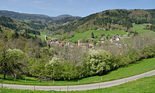
Tegernau is located in the Southern Black Forest Nature Park at an altitude of 380 to 750 meters in the valley of the Kleine Wiese . From Tegernau westward, the Lipplepass leads into the Kandertal via state road 140 . The L 140 leads eastwards via Gresgen into Wiesental to the town of Zell im Wiesental . In the center of the village the L 139 crosses, which leads from Schopfheim downhill to Neuenweg .
structure
The villages of Tegernau, Niedertegernau and Schwand, the Zinken Käppeli and the single house Kuhnigraben are in the area of the former municipality of Tegernau. In the former municipal area are the abandoned villages of Steiningen and Wolfgeringen and near Tegernau the abandoned Neu-Waldeck Castle of the Lords of Waldeck , of which small remains have been preserved.
history
Tegernau was first mentioned as Tegernowa in 1113; later as Tegernau in a papal bull from 1139. In the 13th century, the Tegernau family named themselves after the place. At that time there was already a church that played a central role for the many small villages in the valley, most of which did not have their own church. In 1503 the place came to the margraves of Baden-Durlach , who introduced the Reformation in 1556 . On January 1, 2009, the previously independent municipality of Tegernau was incorporated into the newly founded municipality of Kleines Wiesental.
politics
Tegernau is not only geographically, but also administratively the center of the small meadow valley. Until the merger of the member communities Bürchau , Elbenschwand, Neuenweg , Raich, Sallneck, Tegernau, Wies and Wieslet to form the Kleiner Wiesental community, the community administration association "Kleines Wiesental" had its seat. The community administration association performed the majority of the community administrative tasks of its eight member communities. Its area covered an area of 77.8 km² with more than 3000 inhabitants.
coat of arms
In red, two diagonally crossed golden swords with the tips turned downwards, above a golden crown of leaves. The current coat of arms was awarded in 1965 by the Baden-Württemberg Ministry of the Interior. The coat of arms can already be found in the community seal at the beginning of the 19th century. In 1902, the Baden General State Archives suggested a variant based on the noble family of the King of Tegernau, which showed two diagonally crossed golden arrows pointing upwards. The colors red and gold refer to the Baden coat of arms. This proposal was only implemented in the 1930s, but in the post-war period the old coat of arms was used again.
Buildings
- Evangelical Church Tegernau
- Catholic Church of the Immaculate Conception of Mary
literature
- Tegernau. In: Department State Description of the State Archives Freiburg im Breisgau (editor): District descriptions of the State of Baden-Württemberg. The district of Loerrach. Volume II. B. Community descriptions Kandern to Zell im Wiesental. Published by the Baden-Württemberg State Archives Directorate in conjunction with the Lörrach district. Jan Thorbecke Verlag, Sigmaringen 1994, ISBN 3-7995-1354-X . Pp. 642-660
- Klaus Schubring : Tegernau, the Kleine Wiesental and the Obere Wiesental 900 years ago. In: Das Markgräflerland, Volume 2014, pp. 7–22
- Michael Fautz: The “zur Krone” inn in Tegernau. In: Das Markgräflerland, Volume 2014, pp. 23–32
- Hans Viardot: 15 years of the “Krone” tavern museum in Tegernau. In: Das Markgräflerland, Volume 2014, pp. 33–68
- Peter Müller: Tegernauer Fasnecht. In: Das Markgräflerland, Volume 2014, pp. 100–108
- August Feßler: The Vogtei Tegernau in the year 1770. In: Das Markgräflerland, Heft 4, 1931/32, P. 99-102 digitized of the UB Freiburg
- Franz Xaver Kraus : The art monuments of the Grand Duchy of Baden , Tübingen and Leipzig, 1901, fifth volume - Lörrach district; Pp. 191-192 online
Web links
- Regional information system for Baden-Württemberg (LeoBW): Tegernau - archive material
- Tegernau on the homepage of the Kleines Wiesental community
Individual evidence
- ↑ Entry in Niedertegernau (living space) on discover regional studies online - leobw
- ↑ Entry Schwand (living space) on discover regional studies online - leobw
- ↑ Entry Käppeli (living space) on discover regional studies online - leobw
- ↑ Entry Kuhnigraben (living space) on discover geography online - leobw
- ^ Entry Steiningen (Wüstung) on Discover regional studies online - leobw
- ↑ Entry Wolfgeringen (Wüstung) on Discover regional studies online - leobw
- ^ The state of Baden-Württemberg. Official description by district and municipality. Volume VI: Freiburg region Kohlhammer, Stuttgart 1982, ISBN 3-17-007174-2 . Pp. 894-895
- ^ StBA: Area changes on January 1, 2009
- ↑ Harald Huber: Wappenbuch Landkreis Lörrach . Südkurier GmbH, Konstanz 1984, ISBN 3-87799-046-0 . Pp. 119-120


