
Tornyosnémeti
| Tornyosnémeti | |||||
|
|||||
| Basic data | |||||
|---|---|---|---|---|---|
| State : | Hungary | ||||
| Region : | Northern Hungary | ||||
| County : | Borsod-Abaúj-Zemplén | ||||
| Small area until December 31, 2012 : | Abaúj – Hegyköz | ||||
| District since 1.1.2013 : | Gönc | ||||
| Coordinates : | 48 ° 31 ' N , 21 ° 15' E | ||||
| Height : | 161 m | ||||
| Area : | 14.04 km² | ||||
| Residents : | 469 (Jan 1, 2011) | ||||
| Population density : | 33 inhabitants per km² | ||||
| Telephone code : | (+36) 46 | ||||
| Postal code : | 3877 | ||||
| KSH kódja: | 29054 | ||||
| Structure and administration (as of 2016) | |||||
| Community type : | local community | ||||
| Mayor : | Tibor Vasas (independent) | ||||
| Postal address : | Gazdasor út 12 3877 Tornyosnémeti |
||||
| Website : | |||||
| (Source: A Magyar Köztársaság helységnévkönyve 2011. január 1st at Központi statisztikai hivatal ) | |||||


Tornyosnémeti is a Hungarian community in the county Gönc in Borsod-Abaúj-Zemplén .
Geographical location
Tornyosnémeti is located in northern Hungary, 60 kilometers northeast of the Miskolc county seat , right on the border with Slovakia .
Attractions
- Roman Catholic Church Szűz Mária Neve , built in 1890 ( neo-Gothic )
- Reformed Church, originally built in 1477
- Csáky-Pallavicini Castle ( Csáky-Pallavicini-kastély )
traffic
Road No. 3050 runs through Tornyosnémeti and main road No. 3 to the east of the village . The municipality is located on the railway line from Miskolc to Košice in Slovakia, but trains have not stopped in Tornyosnémeti since the late 1950s, so passengers have to use the station two kilometers south in Hidasnémeti .
photos

Reformed Church in Tornyosnémeti

Road in front of the border crossing to Slovakia
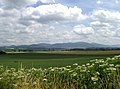
View of the Tokaj Mountains near Tornyosnémeti


Web links
- Official website (Hungarian)
- A tornyosnémeti református templom (Hungarian)