
Under-white
|
Under-white
Large district town of Freital
Coordinates: 51 ° 0 ′ 12 ″ N , 13 ° 36 ′ 58 ″ E
|
|
|---|---|
| Area : | 12 ha |
| Incorporation : | 1919 |
| Incorporated into: | Whitish |
| Postal code : | 01705 |
| Area code : | 0351 |
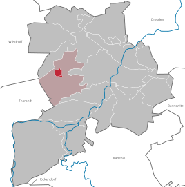  Location of the district Unterweißig in the district of Weißig and in the city of Freital
|
|
Unterweißig is a district in the area of the Weißig district of the large district town of Freital .
geography
The place Unterweißig is in the west of the Freital city area. The twelve-hectare district is completely surrounded by the (Ober-) Weißig district. The two places have almost grown together today. The district road 9077 runs south of Unterweißig and connects the place with the Freital city center as well as Oberweißig and Großopitz (locality of Tharandt ). South of this street is a second part of the Unterweißig district, which is not connected to the larger upper one.
The Weißiger Bach flows along the western development boundary of Unterweißig. Coming from Oberweißig it passes Saalhausen and flows into the Quänebach at Zauckerode .
history
Unterweißig emerged as a workers' settlement in the first half of the 19th century . The residents of Unterweißig worked in the Zauckerode Royal Coal Works , they were brought from Johanngeorgenstadt in the Ore Mountains . Johanngeorgenstadt miners came to the region as early as 1806 and were housed in Döhlen and Oberweißig. As the coal industry grew steadily, there were hardly any affordable housing for the workers in the mines. The surrounding communities turned the miners away in order not to have to pay financial support for miners who were no longer able to work. Therefore, many workers in the forest had to live in tents.
To remedy this, a new settlement was created in the Weißiger Wald in 1821 at the endeavor of Ernst Friedrich Wilhelm Lindig . In 1825 it was named "Unterweißig". Occasionally the place is also called "Neuweißig". Neuweißig grew continuously with the mining activity. In 1834 373 people lived in the village, in 1843 there were 350 inhabitants who lived in 38 houses. Little by little, public buildings were also built, such as a school with a gym.
As an independent rural community, Unterweißig was subordinate to the Dresden office and from 1875 to the Dresden administrative authority. In 1890 the place had 748 inhabitants, by 1910 their number rose to 850. In 1919, Unterweißig's independence ended with the merger with Oberweißig to form the municipality of Weißig. After the end of the Second World War, this municipality became part of the Soviet occupation zone and later the GDR . In the district reform in 1952 , Unterweißig came to the Freital district . Since January 1, 1974, Weißig has belonged to the city of Freital with Ober- and Unterweißig.
supporting documents
- ↑ Weißig with upper and lower white. In: freital.de. Retrieved February 9, 2018 .
Web links
- Information about Unterweißig
- Unterweißig in the Digital Historical Directory of Saxony
Birkigt | Coßmannsdorf | Deuben | Döhlen | Großburgk | Hainsberg | Kleinburgk | Kleinnaundorf | Kohlsdorf | Ugly | Niederhermsdorf | Niederpesterwitz | Oberpesterwitz | Potschappel | Saalhausen | Schweinsdorf | Somsdorf | Under white | Whitish | Wurgwitz | Zauckerode | Zschiedge