
Vierenberg
| Vierenberg | ||
|---|---|---|
 |
||
| height | 255 m above sea level NHN | |
| location | Bad Salzuflen , Lippe district , North Rhine-Westphalia , Germany | |
| Mountains | Lipper mountain country | |
| Coordinates | 52 ° 5 '12 " N , 8 ° 47' 26" E | |
|
||
| particularities | Bismarck Tower | |

The Vierenberg is a 255 m above sea level. NHN high mountain in the area of the city of Bad Salzuflen in the North Rhine-Westphalian district of Lippe in Germany .
location
The Vierenberg is part of the Lipper Bergland , it lies between Bad Salzuflen in the west and the districts of Wüsten in the north, Schötmar in the south and Hollenstein in the east.
Surname
Today there are two interpretations of the name: On the one hand it is derived from "Feuerberg" (Fyrenberg, also Fierenberg), the other version says that the four Germanic deities Tyr , Wodan , Donar and Frigga or Holde were worshiped up here should be. This interpretation would also explain the name of the nearby "Hollenstein" (von Holde). The meaning is basically similar, it tells of solstice fires and offerings .
Hiking trails
About the Four mountain of lead Bumbam- , the soldiers , the butter and the Heuweg - hiking trails, the deserts of Bad Salzuflen and Schötmar connect, as well as on regional Salzeweg , of the 77 kilometer from Bad Salzuflen to Rehburg-Loccum leading Karl-Bachler -Weg ( X or X4 ) and the 72 kilometers long, Herford and Hameln connecting, Hansaweg ( X or X9 ).
Striking (vantage point) points of the Vierenberg are the Hansenkanzel , the Fuchstanz and the Hühnerwiem ; all three are marked with a corresponding memorial stone.
Buildings


Bismarck Tower
To the east of the highest elevation of the Vierenberg stands the Bismarck Tower, inaugurated in 1900 . From its viewing platform, the view extends over Bad Salzuflen, the Teutoburg Forest with the Hermannsdenkmal , the Lippische Bergland up to the Kaiser Wilhelm monument at the Porta Westfalica .
Blunt tower
At the western foothills of the Vierenberg, on the old road to Vlotho , above today's Waldemeine and Gut Steinbeck , stands the Stumpfe Turm - an old watchtower that was built after 1447 at the latest during the city fortifications. The round tower made of sandstone is still around 5.5 meters high and around 4.5 meters in diameter.
Sacrificial stone

A little to the north, below the Bismarck Tower, was the old berth of the sacrificial stone found around 1885 during clearing work and popularly known as the sacrificial stone - a granite boulder around 1.8 meters in diameter. Its almost circular and smoothly ground surface has given rise to speculation and scientific investigations in the past decades, the final result of which is still not available. For example, Professor Krückmann from Münster compared the stone with a cover plate of a stone grave from the Neolithic Age , but does not consider it likely that animal or human sacrifices were made here.
The legend of the Vierenberg
- The giants from the Four Mountains
Hühnen lived on the Vierenberge near Salzuflen and the Tönsberge near Oerlinghausen . But they lived on good terms and visited one another. Once the giant came from the Vierenberge to the Tönsberge and got some sand in his shoe. He took it off and poured the sand on the ground. This is now the mountain on which Leopoldshöhe stands. But it was a long time ago. The giants from the Vierenberge and the Tönsberge shared a common oven. If one wanted to bake or notify the other that the oven was hot, he scratched in the trough, making such a noise that one could clearly hear it in the other giant's apartment. When it was baking day, the giant from Tönsberge heard a violent scrubbing early on. He hurried to get his dough ready and carried it over in a hurry to be ready to bake. When he got to the giant on the Four Hills, he was still in bed. "What's that?" said the other, "you are still asleep, I heard a strong scrubbing for a long time." The Vierenberger replied: "You were wrong, the stove is far from hot. The noise you heard will probably come from the fact that I scratched myself earlier when a flea stung me." Then the Tönsberger was angry, cursed and raged and in his anger took his dough, also that of the other giant and threw it from the mountain onto the ground. This is how Kuhlenhölters Berg came into being.
Plane crash
During the Second World War , on the night of March 24th to 25th, 1944, an English bomber formation was on its way to Berlin . A Lancaster Mk III s under the command of the Royal Australian Air Force was hit by an anti-aircraft gun over Bielefeld and crashed shortly afterwards near Hollenhagen am Vierenberg. Six of the seven Australian crew members were killed in the crash. Four of them were buried on the same day in the desert, two in the Schötmarschen cemetery; one crew member saved himself by parachute and was handed over to the German authorities.
Old views

Vierenberg and Hollenstein
around 1895
Moonlight map "Schlucht am Fierenberge"
around 1907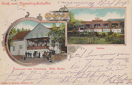
Postcard “Gasthaus Vierenberg”
used in 1912


literature
- Otto Pölert: Deserts - A farm and settlement history .
- Erwin Schubert: Witnesses from the desert past - place names, archway and grave inscriptions . 1990.
Web links
- Deserts - people and history
- The Bismarck Tower at www.bismarcktuerme.de
- The plane crash while searching for clues in OWL
Individual evidence
- ↑ http://www.genealogienetz.de/reg/NRHE-WFA/lippe_ev-d.html#W%C3%BCsten
- ^ Franz Meyer (Ed.): Bad Salzuflen-Epochs of the city history. Publishing house for regional history, Bielefeld 2006, ISBN 978-3-89534-606-4 , p. 37
- ↑ Schwanold, Heinrich and August Wiemann: From Lower Saxony's Sagenborn. Lower Saxony homeland books. Part I: Central Weserland. 2nd series, volume 6. Verlag von Georg Schade, Bad Salzuflen, undated, p. 45.
- ↑ The plane crash at www.spurensuche-owl.de; accessed on October 30, 2016
- ^ Verlag von Rudolf Meyer, Salzuflen (36386)
- ^ Verlag G. Hölscher, Herford