Wöhlsdorf (Auma-Weidatal)
|
Wöhlsdorf
Rural community town of Auma-Weidatal
Coordinates: 50 ° 42 ′ 35 ″ N , 11 ° 57 ′ 28 ″ E
|
|
|---|---|
| Height : | 402 m |
| Incorporation : | July 1, 1950 |
| Incorporated into: | Wiebelsdorf |
| Postal code : | 07955 |
| Area code : | 036626 |
|
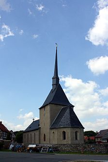
View of the village church
|
|
Wöhlsdorf is a district of the rural community city Auma-Weidatal in the district of Greiz in Thuringia .
geography
Wöhlsdorf is east of the city of Auma on state road 2332. District roads 306 and 308 cross this state road on the southern edge of the village . At the junction of the south- east Thuringian slate mountains and the red sandstone area east of Triptis is the district of the village in hilly terrain .
history
The village was first mentioned on May 17, 1392. A pointed, slightly inclined church tower is the landmark of the village. In the middle of the triangle Wiebelsdorf - Pfersdorf -Wöhlsdorf is the drinking mill of Wöhlsdorf in the valley of the Auma . After 1945 Hilmar Köber was still a miller. He then fled to Germany and the mill was stopped. After that a kindergarten was housed in the mill building and later it was used by the LPG . After the fall of the Wall , resettlers from Russia found their new home here. In 1992 the heirs of the previous owner received the mill back and sold it immediately to private hands.
Individual evidence
- ^ Wolfgang Kahl : First mention of Thuringian towns and villages. A manual. Rockstuhl Verlag, Bad Langensalza 2010, ISBN 978-3-86777-202-0 , p. 318
- ↑ Günter Steiniger: Mills on the Auma, the Triebes, the Leuba and in the Güldetal. Verlag Rockstuhl, Bad Langensalza 2011, ISBN 978-3-86777-296-9 , pp. 45-48 = the drinking mill from Wöhlsdorf
