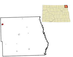
Walhalla, North Dakota
| Valhalla | |
|---|---|
|
Location in North Dakota
|
|
| Basic data | |
| Foundation : | 1845 |
| State : | United States |
| State : | North Dakota |
| County : | Pembina County |
| Coordinates : | 48 ° 55 ′ N , 97 ° 55 ′ W |
| Time zone : | Central ( UTC − 6 / −5 ) |
| Residents : | 996 (as of 2010) |
| Population density : | 359.6 inhabitants per km 2 |
| Area : | 2.77 km 2 (approx. 1 mi 2 ) |
| Height : | 299 m |
| Postal code : | 58282 |
| Area code : | +1 701 |
| FIPS : | 38-82980 |
| GNIS ID : | 1032666 |
| Website : | walhalland.org |
 The Gingras Trading Post in Walhalla, a 1845 erected a trading post, which in since 1975 NRHP listed |
|
Walhalla is a small town (with the status " City ") in Pembina County in the US -amerikanischen State North Dakota . In 2010 , Walhalla had 996 inhabitants.
geography
Walhalla is located in northeast North Dakota on the Pembina River , a left tributary of the Red River of North , which forms the border with Minnesota . The geographical coordinates of Walhalla are 48 ° 55'24 "north latitude and 97 ° 55'05" west longitude. The urban area extends over an area of 2.77 km².
Neighboring places of Walhalla are Neche (33.5 km east-northeast), Cavalier (33.5 km southeast) and Winkler in the Canadian province of Manitoba (30.7 km north).
The nearest major cities are Winnipeg , Manitoba (157 km northeast), Duluth , Minnesota on Lake Superior (587 km east-southeast), Grand Forks (159 km southeast), Fargo (282 km in the same direction) and North Dakota's capital, Bismarck (456 km) km southwest).
The Canadian border is 9.1 km north.
traffic
The North Dakota Highway 32 leads as the main road through Valhalla. All other roads within the urban area are subordinate country roads, some unpaved roads and inner-city connecting roads.
A railway line operated by a regional railway company runs through Walhalla in a north-west-south-east direction.
With the Walhalla Municipal Airport there is a small airfield on the northeastern city limits. The closest major airports are Grand Forks International Airport (159 km south-southeast) and Winnipeg James Armstrong Richardson International Airport (152 km northeast).
history
The first whites in the region were French-speaking fur hunters and traders. The present city was founded in 1845, a few decades before most other localities in North Dakota. There were several trading posts of various fur trading companies in the area. The most famous today is the Gingras Trading Post State Historic Site , which dates back to Antoine Blanc Gingras , a fur trader descended from Métis .
In the 1850s and 1860s, besides fur traders and farmers, Catholic missionaries also came to the region, who converted the native Indians to Catholicism.
The place was initially called St. Joseph and was since 1862 the administrative seat of a county that extended in addition to today's Pembina County over most of the surrounding counties. A post office was opened in the same year.
In 1871 the city was renamed Walhalla . In the 1880s the city got a railway connection, which changed the character of the city to a center of agriculture. But even today, the fur trade still plays a role in Walhalla, along with a number of other trades.
| Population development | |||
|---|---|---|---|
| Census | Residents | ± in% | |
| 1900 | 377 | - | |
| 1910 | 592 | 57% | |
| 1920 | 637 | 7.6% | |
| 1930 | 700 | 9.9% | |
| 1940 | 1138 | 62.6% | |
| 1950 | 1463 | 28.6% | |
| 1960 | 1432 | -2.1% | |
| 1970 | 1471 | 2.7% | |
| 1980 | 1429 | -2.9% | |
| 1990 | 1131 | -20.9% | |
| 2000 | 1057 | -6.5% | |
| 2010 | 996 | -5.8% | |
| 2012 estimate | 975 | -2.1% | |
| 1900-2000 2010 2012 | |||
population
According to the 2010 census , there were 996 people in 439 households in Walhalla. The population density was 359.6 inhabitants per square kilometer. Statistically, 2.21 people lived in each of the 439 households.
The racial the population was composed of 88.3 percent white, 0.1 percent (one person) African American, 8.7 percent Native American and 0.2 percent (two people) from other ethnic groups; 2.7 percent were descended from two or more races. Hispanic or Latino of any race was 1.7 percent of the population.
23.8 percent of the population were under 18 years old, 55.5 percent were between 18 and 64 and 20.7 percent were 65 years or older. 48.6 percent of the population was female.
The average annual income for a household was 40,966 USD . The per capita income was $ 22,753. 15.2 percent of the population lived below the poverty line.
Individual evidence
- ↑ Extract from the National Register of Historic Places - No. 75001305.Retrieved August 2, 2013
- ↑ a b c American Fact Finder. Retrieved August 2, 2013
- ↑ Distance information according to Google Maps. Accessed on August 2, 2013
- ↑ AirNav.com - Walhalla Municipal Airport Accessed on August 2, 2013
- ^ History of Walhalla. Retrieved August 2, 2013
- ^ US Decennial Census. Retrieved August 2, 2013
- ↑ US Census Bureau - Estimate for 2012 ( Memento of the original from October 7, 2014 in the Internet Archive ) Info: The archive link was inserted automatically and has not yet been checked. Please check the original and archive link according to the instructions and then remove this notice. Retrieved August 2, 2013

