West Branch, Iowa
| West Branch | |
|---|---|
 In the center of West Branch |
|
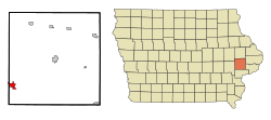
| Location in Iowa | |
| Basic data | |
| Foundation : | 1869 (settled) 1875 (incorporated) |
| State : | United States |
| State : | Iowa |
| Counties : |
Cedar County Johnson County |
| Coordinates : | 41 ° 40 ′ N , 91 ° 21 ′ W |
| Time zone : | Central ( UTC − 6 / −5 ) |
| Residents : | 2,322 (as of 2010) |
| Population density : | 281.1 inhabitants per km 2 |
| Area : | 8.26 km 2 (approx. 3 mi 2 ) |
| Height : | 219 m |
| Postal code : | 52358 |
| Area code : | +1 319 |
| FIPS : | 19-83595 |
| GNIS ID : | 462807 |
| Website : | www.westbranchiowa.org |
| Mayor : | Roger Laughlin (until the end of 2020) |
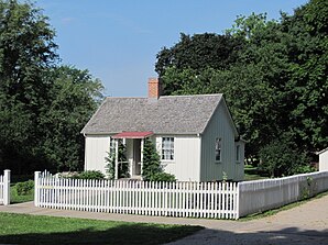
 Birthplace of former President Herbert Hoover in West Branch, listed on the NRHP since 1966 |
|
West Branch is a small town (with the status " City ") in Cedar County and a small part in Johnson County in the US -amerikanischen State Iowa . In 2010 West Branch had 2,322 residents.
geography
West Branch is located in eastern Iowa, about 50 kilometers west of the border of Iowa to Illinois forming Mississippi . The intersection of the three states of Iowa, Illinois and Wisconsin is about 130 km northeast of West Branch, the border with Missouri runs 150 km south.
The geographical coordinates of West Branch are 41 ° 40'17 "north latitude and 91 ° 20'48" west longitude. The urban area extends over an area of 8.26 km² and is mainly in the Springdale Township of Cedar County and a small part in the Scott Township of Johnson County.
Neighboring towns to West Branch are Tipton (16 miles northeast), Rochester (12 miles east), West Liberty (11 miles southeast), Lone Tree (17 miles southwest), Hills (28.1 miles southwest), Iowa City (11.4 miles west) and Solon (16.2 miles northwest).
The closest major cities are Cedar Rapids (54.8 km northwest), Rochester , Minnesota (326 km northwest), the Twin Cities in Minnesota (461 km in the same direction), Wisconsin's capital Madison (279 km northeast) and the Quad Cities in Iowa and Illinois (71 km east), Chicago in Illinois (339 km in the same direction), St. Louis in Missouri (441 km southeast), Kansas City in Missouri (501 km southwest), Iowa's capital Des Moines (198 km west) and Nebraska's largest city, Omaha (420 km in the same direction).
traffic
The west-east running Interstate Highway 80 runs through the metropolitan area of West Branch. All other roads are subordinate country roads, some unpaved roads and inner-city connecting roads.
With the Iowa City Municipal Airport there is a small airfield 14 miles west. The nearest commercial airport is Cedar Rapids - Eastern Iowa Airport (32 miles northwest).
history
|
||||||||||||||||||||||||||||||||||||||||||||||||||||||||||||||||||||
The first white settlers were Quakers who settled on the site of the present city in 1869. Six years later the settlement was incorporated as an independent municipality.
In 1874, the future 31st US President Herbert Hoover was born in West Branch. In 1962, the Herbert Hoover Presidential Library and Museum , one of the 13 presidential libraries, was established in his birthplace . His birthplace, which has the status of a National Historic Landmark , forms the Herbert Hoover National Historic Site with the library and other buildings . Six structures and sites in West Branch are listed on the National Register of Historic Places (NRHP) as of October 1, 2018.
population
According to the 2010 census , West Branch had 2,322 people in 947 households. The population density was 281.1 people per square kilometer. Statistically, 2.39 people lived in each of the 947 households.
The racial the population was composed of 97.0 percent white, 0.4 percent African American, 0.2 percent Native American, 0.6 percent Asian and 0.4 percent from other ethnic groups; 1.3 percent were descended from two or more races. Hispanic or Latino of any race was 2.1 percent of the population.
24.6 percent of the population were under 18 years old, 61.9 percent were between 18 and 64 and 13.5 percent were 65 years or older. 51.2 percent of the population were female.
The average annual income for a household was 60,556 USD . The per capita income was $ 25,274. 4.9 percent of the population lived below the poverty line.
Individual evidence
- ↑ City of West Branch - Mayor and City Council.Retrieved October 1, 2014
- ↑ Extract from the National Register of Historic Places - No. 66000110. Retrieved October 1, 2014
- ↑ a b c American Fact Finder. Retrieved October 1, 2014
- ↑ Distance information according to Google Maps. Accessed October 1, 2014
- ↑ AirNav.com - Iowa City Municipal Airport Accessed 1 October 2014
- ^ State Data Center of Iowa. Retrieved October 1, 2014
- ↑ Clarence Ray Aurner: A Topical History of Cedar County, Iowa Accessed 1 October 2014
- ^ Herbert Hoover Presidential Library and Museum.Retrieved October 1, 2014
- ↑ List of NHL by State . National Park Service , accessed October 1, 2018.
- ↑ Search mask database in the National Register Information System. National Park Service , accessed October 1, 2018.
