
Lutzenberg AR
| AR is the abbreviation for the canton of Appenzell Ausserrhoden in Switzerland and is used to avoid confusion with other entries of the name Lutzenberg . |
| Lutzenberg | |
|---|---|
 |
|
| State : |
|
| Canton : |
|
| District : | former district of Vorderland |
| BFS no. : | 3033 |
| Postal code : | 9426 (Lutzenberg) 9405 (Wienacht-Tobel) |
| Coordinates : | 760 429 / 258854 |
| Height : | 523 m above sea level M. |
| Height range : | 431–796 m above sea level M. |
| Area : | 2.25 km² |
| Residents: | 1279 (December 31, 2018) |
| Population density : | 568 inhabitants per km² |
| Website: | www.lutzenberg.ch |
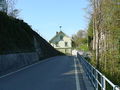
 View from Wienacht to Tobel / Weinberg |
|
| Location of the municipality | |
  |
|
Lutzenberg is a municipality in the foothills of the canton of Appenzell Ausserrhoden in Switzerland .
geography

Lutzenberg is located in the Appenzeller Vorderland and is the northernmost municipality in the canton. The community is divided into two parts, the larger one lies on a northern slope above Rheineck and Thal . The second part of the community is further west, on the foothills of the Rorschacherberg . Both areas are separated by the municipalities of Thal , Heiden AR and Wolfhalden . That is why the municipality of Lutzenberg actually consists of different hamlets such as Brenden, Hof, Haufen, Tobel and Wienacht. The latter two are located in the western municipal area. The lowest point in the community and also the deepest in the canton is at the Dorfhalde at 430 meters. The highest point is at 791 meters above the Tan on the road from Wienacht to Grub SG. Due to the relatively low altitude and the southern slope near Tobel, one of the few vineyards in the canton of Appenzell Ausserrhoden is also located here.
history
Lutzenberg was part of the Kurzenberg community until it split up in 1666 into the independent communities of Heiden, Wolfhalden and Lutzenberg.
population
| Population development | |
|---|---|
| year | Residents |
| 1980 | 880 |
| 2000 | 1323 |
| 2010 | 1254 |
Attractions
photos
Rorschach – Heiden-Bahn , Wienacht station, Lutzenberg community

Rorschach-Heiden-Bahn , Wienacht station, Lutzenberg community


Personalities
- Jakob Hartmann (1876–1956), chimney sweep and folk poet
- Konrad Kellenberger (1907–1976), precision mechanic, founder of the Kellenberger watch collection
- Gertrud Kurz (1890–1972), head of a refugee agency
- Alice Scherrer-Baumann (* 1947), politician
- Ferdinand Schlöth (1818–1891), sculptor, spent the summer half-year from 1874 on his country estate near the village dump in Lutzenberg, where he also died.
- Johann Jakob Tobler (1830–1905), known as Jean Tobler, founder of Chocolat Tobler AG in Bern
- Johann Ulrich Tobler (1703–1787), politician
literature
- Eugen Steinmann: The art monuments of the canton of Appenzell Ausserrhoden, Volume 3: The district of Vorderland. Birkhäuser AG, Basel 1981, ISBN 3-7643-1251-3 . (= The Art Monuments of Switzerland , Volume 72.) pp. 277–305.
Web links
- Official website of the municipality of Lutzenberg
- Thomas Fuchs: Lutzenberg. In: Historical Lexicon of Switzerland .
Individual evidence
- ↑ Permanent and non-permanent resident population by year, canton, district, municipality, population type and gender (permanent resident population). In: bfs. admin.ch . Federal Statistical Office (FSO), August 31, 2019, accessed on December 22, 2019 .
- ↑ Stefan Hess : Between Winckelmann and Winkelried. The Basel sculptor Ferdinand Schlöth (1818–1891). Berlin 2010, ISBN 978-3-86805-954-0 , pp. 72, 81.
- ↑ St. Galler Tagblatt AG, Switzerland: Johann Jakob Tobler: "Grandfather" of the Toblerone . In: St.Galler Tagblatt . ( tagblatt.ch [accessed on September 27, 2017]).
- ↑ Chocolate & Cocoa: Jean Tobler - CV. Retrieved September 27, 2017 .
Buhler | Gais | Grub | Pagans | Herisau | Hundwil | Lutzenberg | Rehetobel | Tail | Schönengrund | Schwellbrunn | Memory | Stone | Teufen | Trogen | Urnaesch | Forest | Waldstatt | Walzenhausen | Wolf heaps
Canton of Appenzell Ausserrhoden | Districts of Switzerland | Municipalities of the canton of Appenzell Ausserrhoden