
Yaracuy
| Yaracuy | ||
|---|---|---|
 .svg) |
||
| Symbols | ||
|
||
| Basic data | ||
| Country | Venezuela | |
| Capital | San Felipe | |
| surface | 7100 km² | |
| Residents | 716,000 (2017) | |
| density | 101 inhabitants per km² | |
| ISO 3166-2 | VE-U | |
| Website | www.yaracuy.gob.ve (Spanish) | |
| politics | ||
| governor | Julio Cesar Leon Heredia | |

Coordinates: 10 ° 25 ′ N , 68 ° 43 ′ W
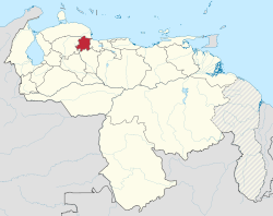
Yaracuy is one of the 23 states of Venezuela . The capital is San Felipe .
Other important cities are Yaritagua, Chivacoa, Aroa, Nirgua and Cocorote. Yaracuy is located in the north of the country and borders the states of Falcón , Lara , Portuguesa , Cojedes and Carabobo in the east.

Yaracuy lies on a plateau and is characterized by mountainous landscapes. In the south is the Tirgua National Park .
The most important branch of the economy is agriculture.
Administrative division
Yaracuy is divided into 14 districts ( Municipios ):
| No | district | Capital |
|---|---|---|
| 1 | Aristides Bastidas | San Pablo |
| 2 | Bolívar | Aroa |
| 3 | Bruzual | Chivacoa |
| 4th | Coco red | Coco red |
| 5 | Independencia | Independencia |
| 6th | Jose Antonio Paez | Sabana de Parra |
| 7th | La Trinidad | Boraure |
| 8th | Manuel Monge | Yumare |
| 9 | Nirgua | Nirgua |
| 10 | Peña | Yaritagua |
| 11 | San Felipe | San Felipe de Yaracuy |
| 12 | Sucre | Guama |
| 13 | Urachiche | Urachiche |
| 14th | Veroes | Farriar |
Web links
States:
Amazonas |
Anzoátegui |
Apure |
Aragua |
Barinas |
Bolívar |
Carabobo |
Cojedes |
Delta Amacuro |
Falcón |
Guárico |
Vargas (La Guaira) |
Lara |
Mérida |
Miranda |
Monagas |
Nueva Esparta |
Portuguesa |
Sucre |
Táchira |
Trujillo |
Yaracuy |
Zulia
Capital District :
Distrito Capital
Federal immediate area:
Dependencias Federales