
Lara (State)
| Lara | |||
|---|---|---|---|
 .svg) |
|||
| Symbols | |||
|
|||
| Basic data | |||
| Country | Venezuela | ||
| Capital | Barquisimeto | ||
| surface | 19,800 km² | ||
| Residents | 2,007,200 (2017 estimate) | ||
| density | 101 inhabitants per km² | ||
| ISO 3166-2 | VE-K | ||
| Website | www.lara.gob.ve (Spanish) | ||
| politics | |||
| governor | Henri Falcon | ||
| Political party | Patria Para Todos (PPT) | ||


Coordinates: 10 ° 4 ′ N , 69 ° 52 ′ W
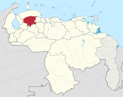
Lara is a federal state of Venezuela with the capital Barquisimeto . It has a size of 19,800 km² and almost 2 million inhabitants.
The south of the state is mountainous (Paramo de Cavimbu, 2200 m), the north and west mostly flat. From the rivers the Río Tocuyo and the Río Yaracuy (both navigable) flow into the Caribbean Sea , while several smaller waters are tributary to the Gulf of Maracaibo and the Orinoco . Agriculture and the breeding of cattle and goats are the main branches of business.
geography
Waters
The Laras rivers flow into the Caribbean, the Orinoco and Lake Maracaibo .
Main rivers
- Río Amarillo
- Río Auro
- Aragua River
- Río Curarigua
- Río Morere
- Rio Tocuyo
- Río Turbio
- Río Urama
- Río Yacambú
Lakes
- Laguna Amarilla
- Laguna Cocoy
history
Pre-Columbian period

Before the arrival of the Spaniards, the region was inhabited by different ethnic groups: Gayones, Ayomanes, Coyones and others. These peoples mainly use languages of the Jirajara language family. The Quíbor , Barquisimeto and El Tocuyo valleys were densely populated and agriculture was well developed.
Colonial times
During the colonial era, the area of Lara was part of the province of Caracas. The region of El Tocuyo had a relatively large number of monasteries that built schools and thus provided better education for the population than elsewhere in the Capitanía General de Venezuela. El Tocuyo was an important place for Venezuela's economy. In the 17th century El Tocuyo had a painting school that communicated a lot with the Quito art school. At the beginning of the 18th century, wheat was grown in Quíbor-Tocuyo and exported to Mexico.
Independence until the end of the 19th century
The first forerunner of the state, the province of Barquisimeto was created from the territory of Carabobo in 1832 after the breakup of Greater Colombia .

In 1856 Yaracuy was split off. These two provinces formed (temporarily together with Falcón ) the sections of the northeastern state, newly created in 1881, which was named after General Jacinto Lara . When the provinces were given greater autonomy and became federal states in 1899, the state of Yaracuy was finally separated.
Administrative division

Lara is divided into 9 districts ( Municipios ):
| Municipio | Administrative headquarters | Population (2011) | Area (km²) |
|---|---|---|---|
|
|
Sanare | 47,245 | 872 |
|
|
Duaca | 49,958 | 875 |
|
|
Barquisimeto | 996.230 | 2760 |
|
|
Quíbor | 100,997 | 768 |
|
|
El Tocuyo | 123,880 | 2231 |
| Palavecino | Cabudare | 174.099 | 440 |
|
|
Sarare | 35,802 | 808 |
|
|
Carora | 185.275 | 7437 |
|
|
Siquisique | 61,381 | 4256 |
politics
The current governor is Henri Falcón, from the Patria Para Todos party . He used to be a member of the Chavez government. But he has been part of the opposition for some time.
Lara in the National Assembly
Lara has 9 of the 165 MPs in the National Assembly. Currently 6 MPs are members of the PSUV , one belongs to Acción Democrática , one is an independent and one is a member of Causa Radical.
economy
The region has always been one of the most important agricultural centers in Venezuela. Sugar cane, coffee, potatoes, tomatoes, beans, corn, bananas and grapes are grown here. Livestock breeding also plays a major role, as does the cheese and dairy industries.
Institutions
The prison Uribana is here.
Individual evidence
- ^ Villa, Marco Aurelio. 1966. Aspectos Geográficos del Estado Lara. Corporación Venezolana de Fomento, Caracas. P. 89.
- ↑ Zinck, Alfred. 1986. Venezuelan Rivers. Lagoven booklets. Lagoven, SA Caracas. 64p. ISBN 980-259-084-3
- ^ Villa, Marco Aurelio. 1966. Aspectos Geográficos del Estado Lara. Corporación Venezolana de Fomento, Caracas. Pp. 89-100.
- ↑ Lara (Venezuela): Municipalities & Urban Places - Population Statistics, Graphics and Map. Retrieved April 15, 2018 .
Web links
States:
Amazonas |
Anzoátegui |
Apure |
Aragua |
Barinas |
Bolívar |
Carabobo |
Cojedes |
Delta Amacuro |
Falcón |
Guárico |
Vargas (La Guaira) |
Lara |
Mérida |
Miranda |
Monagas |
Nueva Esparta |
Portuguesa |
Sucre |
Táchira |
Trujillo |
Yaracuy |
Zulia
Capital District :
Distrito Capital
Federal immediate area:
Dependencias Federales