Zi Shui
| Zi Shui | ||
|
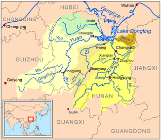
Map with the catchment area and course of the river Zi (= Zi Shui / Zi Jiang) and its two source rivers (light brown). |
||
| Data | ||
| location | Hunan ( PR China ) | |
| River system | Yangtze River | |
| Drain over | Xiang Jiang (Dongting Lake) → Yangtze River → East China Sea | |
| origin | Confluence of two source rivers at Shuangjiangkou in Shaoyang County | |
| muzzle | in the Dongting Sea coordinates: 28 ° 48 ′ 0 ″ N , 112 ° 38 ′ 0 ″ E 28 ° 48 ′ 0 ″ N , 112 ° 38 ′ 0 ″ E
|
|
| length | 653 km | |
| Catchment area | 28,100 km² | |
|
The Zi Shui in Lengshuijiang |
||
The river Zi Shui ( Chinese 資 水 / 资 水 ; English Zi River / Tzu River) or Zi Jiang ( 資 江 / 资 江 , Zī Jiāng , Tzu¹ Chiang¹ ), also Zi River , in central Hunan is one of the most important Tributaries of Dongting Lake ( Dongting Hu ). It is 653 km long and has a catchment area of 28,100 square kilometers.
It has a southern and a western source river. The southern originates in the south of Ziyuan County of the Guangxi Autonomous Region of the Zhuang, the western one in the Chengbu Autonomous County of the Miao (in Hunan). It is only from Shuangjiangkou in Shaoyang County that it bears the name Zi Shui or Zi Jiang.
Web links
Footnotes
- ^ Cihai , Shanghai cishu chubanshe, Shanghai 2002, ISBN 7-5326-0839-5 , p. 2272.

