Li Shui
| Li Shui | ||
|
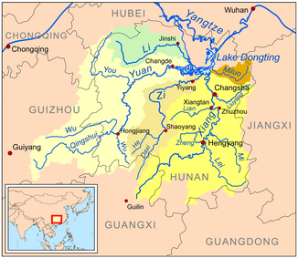
Map with the catchment area and course of the Li Shui (green) |
||
| Data | ||
| location | Hunan ( PR China ) | |
| River system | Yangtze River | |
| Drain over | Xiang Jiang (Dongting Lake) → Yangtze River → East China Sea | |
| source | in the north of Sangzhi County | |
| muzzle | in the Dongting Sea coordinates: 29 ° 8 ′ 0 ″ N , 112 ° 9 ′ 0 ″ E, 29 ° 8 ′ 0 ″ N , 112 ° 9 ′ 0 ″ E
|
|
| length | 388 km | |
| Catchment area | 18,500 km² | |
| Reservoirs flowed through | Dongjiang Dam | |
The Li Shui River or the Li River or Lishui River ( Chinese 澧水 , Pinyin Lǐ Shuǐ ; English Lishui River / Li River) is a river in the northwest of the Chinese province of Hunan . It is one of the main tributaries of the Dongting Lake ( Dongting Hu ), which in turn drains into the Yangtze River .
Its main source is in the north of Sangzhi County of Zhangjiajie . It flows through the areas of Cili , Shimen , Li , Jinshi and Anxiang .
Its total length is 388 km, its catchment area 18,500 square kilometers.
See also
Footnotes
- ↑ Cihai , Shanghai cishu chubanshe, Shanghai 2002, ISBN 7-5326-0839-5 , p. 1004.
