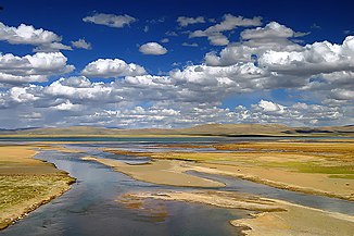
Tuotuo He
|
Tuotuo He Ulan Moron |
||
| Data | ||
| location | Qinghai ( PR China ) | |
| River system | Yangtze River | |
| Drain over | Tongtian He → Jinsha Jiang → Chuan Jiang → Yangzi Jiang → East China Sea | |
| source | (eastern source river) southwest of Geladandong 33 ° 26 '40 " N , 90 ° 56' 10" O |
|
| Association with |
Dam Chu zum Tongtian He Coordinates: 34 ° 5 ′ 32 " N , 92 ° 54 ′ 47" E 34 ° 5 ′ 32 " N , 92 ° 54 ′ 47" E
|
|
| length | 375 km | |
| Tibetan name |
|---|
|
Tibetan script :
ཐོག་ ཐོག་ ཆུ་
|
|
Wylie transliteration : dmar chu
|
| Chinese name |
|
Simplified :
沱沱河
|
|
Pinyin : Tuótuó Hé
|
The Tuotuo He or Tuotuo River ( Chinese 沱沱河 , Pinyin Tuótuó hé ; English T'uo-t'uo River and others) is a river in the headwaters of the Yangtze River .
It has two source rivers : the eastern one rises southwest of the snow-covered Geladandong in western Tanggula Shan in the southwest of the Chinese province of Qinghai . The end of the glacier is about 5,500 m above sea level. Its Mongolian name Ulan Moron / Ulaan Mörön "Red River" is due to its red-brown water. It is considered to be the origin of the Yangtze River . Tuotuo He is 375 km long.
The Qinghai-Tibet Railway runs over the Great Bridge of the Yangtze River Headwaters ▼ ( 長江源 特 大橋 / 长江源 特 大桥 , English Changjiangyuan Grand Bridge - "First Yangtze River Bridge") with a length of 1,389.6 m across the river .
See also
Web links
- Tuotuo River Town (English)
- Desperate Times at the Headwaters of the Yangtze ( Memento of October 9, 2007 in the Internet Archive )
- The origin of the Yangzte River: the Tuotuo River - photo
- Tuotuo River Bank - photo
Footnotes
- ↑ The English Wikipedia has an article on Geladandong
- ↑ Tuotuo River ( Memento from December 4, 2008 in the Internet Archive ) on ChinaCulture.org (English).
- ↑ 长江源 特 大桥 与 沱沱河 ( Changjiangyuan Teda Qiao yu Tuotuo He ) on Sina.com from June 29, 2006 (Chinese).
| Tuotuo He (alternative names of the lemma) |
|---|
| 玛曲; 托托 河; 乌兰 木 伦 河 |

