Anning Hey
|
Anning He Baisha Jiang |
||
| Data | ||
| location | Sichuan ( PR China ) | |
| River system | Yangtze River | |
| Drain over | Yalong Jiang → Yangtze River → East China Sea | |
| origin | Confluence of several source streams in the Mianning District 28 ° 48 ′ 29 ″ N , 102 ° 15 ′ 44 ″ E |
|
| Source height | 2133 m | |
| muzzle |
Yalong Jiang Coordinates: 26 ° 43 '40 " N , 101 ° 51' 34" E, 26 ° 43 '40 " N , 101 ° 51' 34" E |
|
| Mouth height | 1068 m | |
| Height difference | 1065 m | |
| Bottom slope | approx. 3.3 ‰ | |
| length | approx. 320 km | |
| Catchment area | approx. 11,000 km² | |
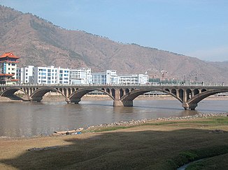
The Anning He or Anning River ( Chinese 安寧 河 / 安宁 河 , Pinyin Ānníng hé ), also known by the name Baisha Jiang ( 白沙 江 ) and several other names, is a major tributary of the lower Yalong Jiang in the southwest of China Province of Sichuan . It rises at the southern foot of the mountain Gongga Shan on the mountain Pusa transition ( 菩薩崗 / 菩萨岗 ) in the circle Mianning of Autonomous Prefecture of Liangshan Yi and flows south through the territories of Mianning, Xichang , Dechang and Miyi . The Anning He is about 320 km long, its catchment area has an area of about 11,000 km 2 .
The Anninghe Fault ( Chinese 安寧 河 斷裂帶 / 安宁 河 断裂带 , Pinyin Ānníng hé duànlièdài ) is named after him.
Web links
Individual evidence
- ↑ a b Soviet General Staff Map (accessed from topomapper.com on October 27, 2012)
