Czołpino: Difference between revisions
Magioladitis (talk | contribs) m →External links: Fix Commons category, replaced: {{Commons category-inline|{{#property:P373}}}} → {{Commons category-inline}} using AWB |
m Format administrative division links, remove DEFAULTSORTKEY as per WP:SORTKEY, remove One Source for stubs, minor formatting changes (AWB) |
||
| (4 intermediate revisions by 4 users not shown) | |||
| Line 3: | Line 3: | ||
| settlement_type = Village |
| settlement_type = Village |
||
| total_type = |
| total_type = |
||
| image_skyline = Czołpino |
| image_skyline = Latarnia morska Czołpino widziana od strony ścieżki.jpg |
||
| image_caption = |
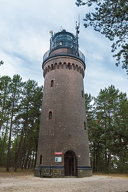
| image_caption = Czołpino Lighthouse |
||
| image_flag = |
|||
| image_shield = |
|||
| image_map = |
| image_map = |
||
| coordinates_region = PL |
|||
| subdivision_type = [[Countries of the world|Country]] |
| subdivision_type = [[Countries of the world|Country]] |
||
| subdivision_name = {{ |
| subdivision_name = {{POL}} |
||
| subdivision_type1 = [[Voivodeships of Poland|Voivodeship]] |
| subdivision_type1 = [[Voivodeships of Poland|Voivodeship]] |
||
| subdivision_name1 = [[Pomeranian Voivodeship|Pomeranian]] |
| subdivision_name1 = [[Pomeranian Voivodeship|Pomeranian]] |
||
| subdivision_type2 = [[Powiat|County]] |
| subdivision_type2 = [[Powiat|County]] |
||
| subdivision_name2 = [[Słupsk County]] |
| subdivision_name2 = [[Słupsk County|Słupsk]] |
||
| subdivision_type3 = [[Gmina]] |
| subdivision_type3 = [[Gmina]] |
||
| subdivision_name3 = [[Gmina Smołdzino|Smołdzino]] |
| subdivision_name3 = [[Gmina Smołdzino|Smołdzino]] |
||
| coordinates = {{coord|54|42|37|N|17|14|20|E|region:PL|display=inline,title}} |
|||
| latd = 54 |
|||
| latm = 42 |
|||
| lats = 37 |
|||
| latNS = N |
|||
| longd = 17 |
|||
| longm = 14 |
|||
| longs = 20 |
|||
| longEW = E |
|||
| coordinates_display = inline,title |
|||
| pushpin_map = Poland |
| pushpin_map = Poland |
||
| pushpin_label_position = right |
| pushpin_label_position = right |
||
| timezone = [[Central European Time|CET]] |
|||
| utc_offset = +1 |
|||
| timezone_DST = [[Central European Summer Time|CEST]] |
|||
| utc_offset_DST = +2 |
|||
| elevation_m = |
| elevation_m = |
||
| population_total = |
| population_total = |
||
| registration_plate = GSL |
|||
| website = |
| website = |
||
| ⚫ | '''Czołpino''' {{IPAc-pl|cz|o|U|'|p|i|n|o}} ({{lang-de|Scholpin}}) is a village in the administrative district of [[Gmina Smołdzino]], within [[Słupsk County]], [[Pomeranian Voivodeship]], in northern Poland.<ref name="TERYT">{{cite web |url=http://www.stat.gov.pl/broker/access/prefile/listPreFiles.jspa |title=Central Statistical Office (GUS) - TERYT (National Register of Territorial Land Apportionment Journal) |date=2008-06-01 |language=Polish}}</ref> It lies approximately {{convert|6|km|mi|0}} north of [[Smołdzino, Słupsk County|Smołdzino]], {{convert|31|km|mi|0|abbr=on}} north-east of [[Słupsk]], and {{convert|98|km|mi|0|abbr=on}} north-west of the regional capital [[Gdańsk]]. It is within the [[Slovincian National Park]]. |
||
}} |
|||
| ⚫ | '''Czołpino''' {{IPAc-pl|cz|o|U|'|p|i|n|o}} ({{lang-de|Scholpin}})<ref>{{cite book|title=Ortsnamenverzeichnis der Ortschaften jenseits von Oder u. Neiße |author=M. Kaemmerer|year=2004| ISBN= 3-7921-0368-0 |language=German}}</ref> is a village in the administrative district of [[Gmina Smołdzino]], within [[Słupsk County]], [[Pomeranian Voivodeship]], in northern Poland.<ref name="TERYT">{{cite web |url=http://www.stat.gov.pl/broker/access/prefile/listPreFiles.jspa |title=Central Statistical Office (GUS) - TERYT (National Register of Territorial Land Apportionment Journal) |date=2008-06-01 |language=Polish}}</ref> It lies approximately {{convert|6|km|mi|0}} north of [[Smołdzino, Słupsk County|Smołdzino]], {{convert|31|km|mi|0|abbr=on}} north-east of [[Słupsk]], and {{convert|98|km|mi|0|abbr=on}} north-west of the regional capital [[Gdańsk]]. It is within the [[Slovincian National Park]], on the [[Slovincian Coast]], in the historic region of [[Pomerania]]. |
||
==History== |
|||
Since the 12th century the area was part of the [[Holy Roman Empire]] ([[Duchy of Pomerania]]), 1648-1945 [[Prussia]] and [[Germany]]. After [[World War II]] the region was placed under Polish administration and [[ethnic cleansing|ethnically cleansed]] according to the post-war [[Potsdam Agreement]]. The native German populace was [[expulsion of Germans after World War II|expelled]] and replaced with [[Poles]]. For the history of the region, see ''[[History of Pomerania]]''. |
|||
The area became part of the emerging Polish state in the 10th century. Following Poland's fragmentation, it formed part of the [[Duchy of Pomerania]] and other splinter duchies. From the 18th century it was part of the [[Kingdom of Prussia]], and from 1871 it was also part of [[Germany]]. Following Germany's defeat in [[World War II]] in 1945, the area became again part of Poland. |
|||
==References== |
==References== |
||
| Line 44: | Line 40: | ||
{{Polish coast}} |
{{Polish coast}} |
||
{{DEFAULTSORT:Czolpino}} |
|||
[[Category:Villages in Słupsk County]] |
[[Category:Villages in Słupsk County]] |
||
Latest revision as of 07:01, 4 October 2023
Czołpino | |
|---|---|
Village | |
 Czołpino Lighthouse | |
| Coordinates: 54°42′37″N 17°14′20″E / 54.71028°N 17.23889°E | |
| Country | |
| Voivodeship | Pomeranian |
| County | Słupsk |
| Gmina | Smołdzino |
| Time zone | UTC+1 (CET) |
| • Summer (DST) | UTC+2 (CEST) |
| Vehicle registration | GSL |
Czołpino [t͡ʂɔu̯ˈpinɔ] (German: Scholpin)[1] is a village in the administrative district of Gmina Smołdzino, within Słupsk County, Pomeranian Voivodeship, in northern Poland.[2] It lies approximately 6 kilometres (4 mi) north of Smołdzino, 31 km (19 mi) north-east of Słupsk, and 98 km (61 mi) north-west of the regional capital Gdańsk. It is within the Slovincian National Park, on the Slovincian Coast, in the historic region of Pomerania.
History[edit]
The area became part of the emerging Polish state in the 10th century. Following Poland's fragmentation, it formed part of the Duchy of Pomerania and other splinter duchies. From the 18th century it was part of the Kingdom of Prussia, and from 1871 it was also part of Germany. Following Germany's defeat in World War II in 1945, the area became again part of Poland.
References[edit]
- ^ M. Kaemmerer (2004). Ortsnamenverzeichnis der Ortschaften jenseits von Oder u. Neiße (in German). ISBN 3-7921-0368-0.
- ^ "Central Statistical Office (GUS) - TERYT (National Register of Territorial Land Apportionment Journal)" (in Polish). 2008-06-01.
External links[edit]
 Media related to Czołpino at Wikimedia Commons


