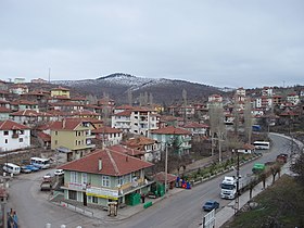
Çamlıdere (Ankara)
| Çamlıdere | ||||
|
||||

|
||||
| Basic data | ||||
|---|---|---|---|---|
| Province (il) : | Ankara | |||
| Coordinates : | 40 ° 29 ' N , 32 ° 29' E | |||
| Height : | 1175 m | |||
| Telephone code : | (+90) 312 | |||
| Postal code : | 06 740 | |||
| License plate : | 06 | |||
| Structure and administration (as of 2019) | ||||
| Structure : | 48 mahall | |||
| Belediye Başkanı: | Hazım Caner Can ( AKP ) | |||
| Postal address : | 06740 Çamlıdere / Ankara Körler Mah. Cumhuriyet Cad. Barış Sok. No: 01 |
|||
| Website: | ||||
| Çamlıdere County | ||||
| Residents : | 15,148 (2018) | |||
| Surface: | 782 km² | |||
| Population density : | 19 inhabitants per km² | |||
| Kaymakam : | Mutlu Köksal | |||
| Website (Kaymakam): | ||||
Çamlıdere is a municipality in the province of Ankara , the area of which coincides with that of the İlçe (state administrative district) of the same name . The community belongs to the Ankara Metropolitan Municipality (Ankara Büyükşehir Belediyesi) and forms one of its district communities.
The district is located on the northwest border of Ankara Province and is enclosed in the southeast and northeast by the district of Kızılcahamam and in the northwest by the province of Bolu ; in the south it borders on the districts of Güdül and Beypazarı . The landscape is mountainous and 66% wooded with conifer (pine) and oak stands. Climatically, the district lies in the transition from the Central Anatolian to the Pontic climate. The Çamlıdere Reservoir in the district provides 70% of Ankara's drinking water.
The old name of Çamlıdere was Ali Dede Şeyhler köyü . The name refers to a Şeyh Ali Semerkandi who settled there in the 15th century. Its Türbe , which is a popular destination for pilgrims, is in Çamlıdere. The village of Ali Dede Şeyhler was in Nahiye Şorba des Kaza (Ottoman judicial district and forerunner of the İlçe) Yabanabad (today's Kızılcahamam). In 1907, the administrative center of Nahiye Şorba was moved to the village of Ali Dede Şeyhler. In 1930 Yabanabad was renamed Kızılcahamam and the Nahiye became Bucak. In 1935 the name of the settlement and the Bucak changed to Çamlıdere. In 1953 Çamlıdere was then raised to İlçe.
Individual evidence
- ↑ Nufusu.com Türkiye Nüfusu, accessed on August 30, 2019
- ↑ ( Page no longer available , search in web archives: İLÇENİN COĞRAFİK YAPISI )
- ↑ ( Page no longer available , search in web archives: Çamlıdere )
- ↑ ( page no longer available , search in web archives: archived copy )


