Almaguer (Colombia)
| Almaguer | ||
|---|---|---|
|
Coordinates: 1 ° 55 ′ N , 76 ° 51 ′ W Almaguer on the map of Colombia
|
||
|
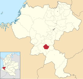
Location of the municipality of Almaguer on the map of Cauca
|
||
| Basic data | ||
| Country | Colombia | |
| Department | Cauca | |
| City foundation | 1551 | |
| Residents | 21,374 (2019) | |
| City insignia | ||
| Detailed data | ||
| surface | 320 km 2 | |
| Population density | 67 inhabitants / km 2 | |
| height | 2312 m | |
| Time zone | UTC -5 | |
| City Presidency | Darío Albeiro Galíndez (2016-2019) | |
| Website | ||
| View of Almaguer | ||
Almaguer is a municipality ( municipio ) in the department of Cauca in Colombia .
geography
Almaguer is located in the south of Cauca in the Provincia del Sur . The municipality borders La Vega in the north , San Sebastián in the east and south and Bolívar in the west .
population
The municipality of Almaguer has 21,374 inhabitants, of which only 1587 live in the urban part (cabecera municipal) of the municipality (as of 2019).
Personalities
- Manuel María Paz (1820–1902), soldier, cartographer and draftsman
Web links
Commons : Almaguer - collection of images, videos and audio files
- Alcaldía Municipal de Almaguer Cauca. Alcaldía de Almaguer - Cauca, accessed February 7, 2019 (Spanish, municipality website).
Individual evidence
- ↑ ESTIMACIONES DE POBLACIÓN 1985 - 2005 Y PROYECCIONES DE POBLACIÓN 2005 - 2020 TOTAL DEPARTAMENTAL POR ÁREA. DANE, May 11, 2011, accessed on February 7, 2019 (Spanish, extrapolation of the population of Colombia (Excel; 1.72 MB)).


