Alto Amazonas Province
| Alto Amazonas Province | ||
|---|---|---|
 Location of the province in the Loreto region |
||
| Symbols | ||
|
||
| Basic data | ||
| Country | Peru | |
| region | Loreto | |
| Seat | Yurimaguas | |
| surface | 18,764 km² | |
| Residents | 122,725 (2017) | |
| density | 6.5 inhabitants per km² | |
| founding | February 7, 1866 | |
| ISO 3166-2 | PE-LOR | |
| Website | altoamazonas.gob.pe (Spanish) | |
| politics | ||
| Alcalde Provincial | Hugo Araujo Del Águila (2019-2022) |
|
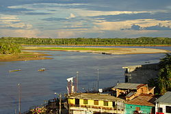
| Yurimaguas and Rio Huallaga | ||
Coordinates: 5 ° 54 ′ S , 76 ° 6 ′ W
The Alto Amazonas province is located in the Loreto region in northeast Peru . The province has an area of 18,764 km². The population in 2017 was 122,725. Ten years earlier the population was 104,667. The capital of the province is Yurimaguas . 78% of the province's area is forested; its inhabitants live mainly from forestry, hunting and fishing. About 9% of the total area is used for agriculture.
Geographical location
The province of Alto Amazonas lies in the west of the Loreto region in the Amazon lowlands . Only in the extreme south-west does the province extend to the Peruvian Eastern Cordillera . The rivers Río Huallaga , Río Paranapura , Río Nucuray and the Río Marañón flow through the province. In the east the province of Alto Amazonas borders on the province of Loreto , in the southeast on the province Requena , in the south on the San Martín region and in the west on the province Datem del Marañón .
Administrative division
The Alto Amazonas Province is divided into six districts. The district of Yurimaguas is the seat of the provincial administration.
| District | Administrative headquarters |
|---|---|
| Balsapuerto | Balsapuerto |
| Jeberos | Jeberos |
| Lagunas | Lagunas |
| Santa Cruz | Santa Cruz |
| Teniente César López Rojas | Shucushuyacu |
| Yurimaguas | Yurimaguas |
history
The area was originally inhabited by the Indian tribes of the Yuris and Omaguas , who lived on the upper reaches of the Rio Acre and the Rio Juruá . The largest indigenous groups living in the Alto Amazonas province today are the Chayahuita (also called Tshaawi, sometimes spelled “Shawi”) and the Jebero (also: Xebero).
The province was created by decree of February 7, 1866. This decree was ratified by Congress by Act of September 11, 1868.
On May 26, 2019, an earthquake with a magnitude of 8.0 on the moment magnitude scale occurred . It mainly hit the eastern and northeastern parts of the Alto Amazonas province.
literature
- Aldo Fuentes: Porque las piedras no mueren. Historia, sociedad y ritos de los Chayahuita del Alto Amazonas . Centro Amazónico de Antropología y Aplicación Práctica, Lima 1988.
- Cuentos amazónicos. Leyendas y costumbres de la selva, escritas por autores de Alto Amazonas, Yurimaguas, Perú . Educacion para el Desarrollo Amazónico, Yurimaguas 2003.
Individual evidence
- ↑ Instituto Nacional de Estadística e Informática (INEI): Directorio Nacional de Centros Poblados - Censos Nacionales 2017 . Lima 2018, Vol. 4, p. 1392 ( online ).
- ^ A b Alto Amazonas, province in the Loreto region . www.citypopulation.de. Retrieved November 29, 2019.
- ^ Gloria Soto Valdivia: Léxico del grupo etnolingüístico chayahuita (Alto Amazonas, Loreto) . Centro Amazónico de Antropología y Aplicación Práctica, Lima 1983.
- ↑ Enrique Vera: Sismo en Loreto: la iglesia del centro poblado Santa Cruz que quedó en escombros. In: El Comercio , May 28, 2019, accessed May 31, 2019.

