
Altvaterturm (whetstone)
| Altvaterturm | |
|---|---|
| Tower type: | Observation tower |
| State : | Germany |
| Country : | Thuringia |
| County : | District of Saalfeld-Rudolstadt |
| Location : | Brennersgrün (near) |
| Location : | in the Franconian Forest , on the whetstone |
| Geo coordinates : | 50 ° 27 '0.5 " N , 11 ° 27' 20.8" E |
| Site altitude: | approx. 788 m above sea level NHN |
| Tower height: | approx. 35.8 m |
| Base area : | 11.2 × 14.5 m |
| Viewing platform : | 824 m above sea level NN |
| Building material : | Sandstone |
| Construction time : | from 1999 |
| Laying of the foundation stone : | May 11, 2000 |
| Inauguration : | August 28, 2004 |

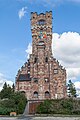
The Altvaterturm is a 35.8 m high observation tower on the Wetzstein ( 792.7 m above sea level ), a mountain in the Franconian Forest near Brennersgrün in the Saalfeld-Rudolstadt district of Thuringia . Some of the tower rooms are used as a museum.
Geographical location
The Altvaterturm stands in the north-northwest of the Franconian Forest on the summit region of the Wetzstein in the Thuringian Slate Mountains / Obere Saale Nature Park . It is located 1.6 km north-west of Brennersgrün, a south-south-east part of the city of Lehesten , and about 350 m north-north-east of the former location of the Lehesten Bismarck Tower, which was blown up in 1979 .
history
After the Germans were expelled from Czechoslovakia in 1945/46, Heimatfreunde founded the Langgöns Altvaterturmverein in 1976 . The registered association established in 1999 to collapsed on May 2, 1959, and not rebuilt Altvaterturm faithfully on the whetstone - as a memorial of the expulsion. It is a replica of 1912 in the near- Altvatergebirge located mountain Altvater built Habsburgwarte that last Altvaterturm said.
For the history of the tower of the old tower, see also: Section History of the Old Father's Tower in the Praděd mountain article
The tower location for today's Altvaterturm was chosen because it comes close to the natural features of the Altvatergebirge. After first contacts with the city of Lehesten in 1995 , the Thuringian State Administration Office issued the building permit in October 1998. The groundbreaking ceremony took place on April 11, 1999, the foundation stone was laid on May 21, 2000 and construction began on November 1, 2000. The topping-out ceremony was celebrated on May 11, 2002 and the tower was inaugurated on August 28, 2004.
Technical specifications
Some dates from the Old Father Tower:
- Height: 35.8 m
- Base area: 11.2 × 14.5 m
- Enclosed space: approx. 3,000 m³
- Viewing height on the open viewing platform: ( 824 m above sea level )
Design
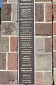
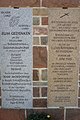
In the basement there is the St. Elisabeth Chapel with plaques for the towns and communities from which Sudeten Germans were expelled due to the Beneš decrees . They provide information about the number of inhabitants around 1939, the number of those killed in World War II and those who perished as a result of displacement. There is a restaurant on the ground floor, the walls of which are decorated with wooden coats of arms of the home communities. Commemorative plaques in the niches of the outer facade show the events of the displacement years. The 16 sculptures on the battlements symbolize 16 million displaced and 16,000 people killed after the end of the war. In the stairwell, double coats of arms represent the places of displacement and the new places of residence. On the upper floors, individual rooms are used for exhibitions on the former German settlement areas. The East Prussia area is looked after by the East Prussia Cultural Center . On the top floor there is the hall of honor, which is decorated with votive tiles on the walls , and above it a viewing platform. There is an open-air stage in front of the tower.
The following rooms and facilities are located in the hall on different floors of the building:
- Room: Minerals of the Jeseníky Mountains
- Zuckmantel home parlor
- Documentation on eviction
- Room Lehesten and surroundings
- Mährisch Schönberg room with a model of the Teßal Railway and aircraft models
- East Prussian Room of the East Prussian Landsmannschaft Hamburg
Opportunities for viewing
From the Altvaterturm the view falls to the northwest to the Thuringian Forest with the Bleßberg ( 866.9 m ) and Großer Beerberg ( 982.9 m ), to the east to the Ore Mountains with the Auersberg ( 1018.2 m ), across the Franconian Forest Southeast to the Fichtelgebirge with the Großer Kornberg ( 827 m ) and Schneeberg ( 1051 m ) and to the southwest to the Franconian Alb with the Staffelberg ( 539 m ).
photos
Altvaterturm on the whetstone

Open-air stage in front of the tower
Memorial plaque on the old Altvaterturm
Memorial plaques


Web links
- Altvaterturm (Altvaterturmverein e.V.), on altvaterturm.de
- Altvaterturm. In: Structurae
- Panoramic view from Altvaterturm (labeling of visual targets can be activated), on panorama-photo.net
Individual evidence
- ↑ a b c d e f g h i j Flyer Der neue Altvaterturm , edition: September 2011, accessed on September 10, 2016, at sockenqualmer.de (PDF; 1.39 MB)
- ↑ Map services of the Federal Agency for Nature Conservation ( information )
- ↑ Heimatstuben in the new Altvaterturm (Federal Institute for Culture and History of Germans in Eastern Europe), accessed on September 10, 2016, at bkge.de