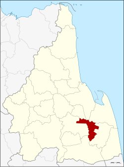
Amphoe Chaloem Phra Kiat (Nakhon Si Thammarat)
|
Chaloem Phra Kiat เฉลิมพระเกียรติ |
|
|---|---|
| Province: | Nakhon Si Thammarat |
| Surface: | 124.1 km² |
| Residents: | 31,520 (2012) |
| Population density : | 269.7 U / km² |
| ZIP : | 80190, 80290, 80350 |
| Geocode : | 8023 |
| map | |

|
|
Amphoe Chaloem Phra Kiat ( Thai : อำเภอ เฉลิมพระเกียรติ ) is a district ( Amphoe - administrative district) in the province of Nakhon Si Thammarat . The province of Nakhon Si Thammarat is located in the southern region of Thailand , about 780 km south of Bangkok on the east coast of the Malay Peninsula to the Gulf of Thailand .
geography
Neighboring districts (clockwise from the north): Phra Phrom District , Mueang Nakhon Si Thammarat , Pak Phanang , Chian Yai , Cha-uat and Ron Phibun . All Amphoe are in Nakhon Si Thammarat Province.
history
Amphoe Chaloem Phra Kiat was established on December 5, 1996 together with four other counties with the same name Chaloem Phra Kiat to celebrate the 50th anniversary of the throne of King Bhumibol Adulyadej (Rama IX) .
The district was created from the three tambon Chian Khao, Don Tro and Suan Luang of the district Chian Yai and the tambon Thang Phun from the district Ron Phibun .
administration
Provincial Administration
Amphoe Ron Phibun is divided into four communities ( tambon ) , which in turn are divided into 37 villages ( muban ) .
|
Local administration
There are two small towns ( Thesaban Tambon ) in the county:
- Thang Phun ( เทศบาล ตำบล ทาง พูน ) consists of the whole tambon Thang Phun.
- Don Tro ( เทศบาล ตำบล ดอน ต รอ ) consists of the whole tambon Don Tro.
The other two tambon are each managed by a “tambon administration organization” (TAO, องค์การ บริหาร ส่วน ตำบล ).
Individual evidence
- ↑ พระราชกฤษฎีกา ตั้ง อำเภอ เฉลิมพระเกียรติ จังหวัด นครราชสีมา อำเภอ เฉลิมพระเกียรติ จังหวัด นครศรีธรรมราช อำเภอ เฉลิมพระเกียรติ จังหวัด น่าน อำเภอ เฉลิมพระเกียรติ จังหวัด บุรีรัมย์ และ อำเภอ เฉลิมพระเกียรติ จังหวัด สระบุรี พ.ศ. ๒๕๓๙ . In: Royal Gazette . 113, No. 62 ก , 20 November 1996, pp. 1-4.
- ↑ Population statistics 2012 . Department of Provincial Administration. Retrieved July 7, 2014.
Web links
Coordinates: 8 ° 11 ' N , 100 ° 2' E

