
Balbach (Tauber)
| Balbach | ||
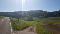
 The Balbach near Unterbalbach shortly before it flows into the Tauber, 2018 |
||
| Data | ||
| Water code | DE : 24658 | |
| location |
Tauberland
|
|
| River system | Rhine | |
| Drain over | Tauber → Main → Rhine → North Sea | |
| source | approx. 1.5 km northeast of Bütthard- Oesfeld near the district road WÜ 37 49 ° 34 ′ 28 ″ N , 9 ° 51 ′ 31 ″ E |
|
| Source height | approx. 325 m above sea level NHN | |
| muzzle | near Lauda-Königshofen- Unterbalbach from the right and from the northeast into the middle Tauber coordinates: 49 ° 31 '53 " N , 9 ° 44' 13" E 49 ° 31 '53 " N , 9 ° 44' 13" E |
|
| Mouth height | approx. 192 m above sea level NHN | |
| Height difference | approx. 133 m | |
| Bottom slope | approx. 11 ‰ | |
| length | approx. 12 km | |
| Catchment area | 32.663 km² | |
| Communities |
Only catchment -Zwickel: Bad Mergentheim |
|
The Balbach is a 12 km long, roughly southwest running brook, initially in the Bavarian district of Würzburg , later in the Main-Tauber district of Baden-Württemberg , which flows into the middle Tauber from the right in the Unterbalbach district of the city of Lauda-Königshofen .
Surname
The name of the body of water - like the basic word Bach itself and its many other compositions - has, in addition to the usually male gender in the local dialect, also the female gender in dialect.
geography
course
The Balbach arises a little south of the Bütthard community forest near the district road WÜ 37 to Oesfeld at about 325 m above sea level. NHN . An initial trench, fed from a pipe, begins here. According to the official map, there is a spring in the adjacent field a little to the west of the pipe end, but this cannot be confirmed on aerial photos by a recognizable channel, runoff, changed vegetation color or the like. However, at the beginning of the ditch, a 150-meter-long channel runs from the northeast, which begins at the tip of a forest island in front of the community forest.
The ditch of the Balbach follows dirt roads in a fairly soon south-westerly direction, less than 300 meters from the district road. After he has crossed the Oesfeld, which is mostly on the right, his first somewhat larger tributary, the Tiefer Wiesenbach, runs from the east-northeast. Now the previously completely bare ditch, which is now a little deeper, is followed with interruptions by a gallery. Around where the Mulde becomes the Kerbtal, there is forest on the left slope, soon afterwards from the state border with Baden-Württemberg on the right.
Shortly after this, near the hamlet of Neubronn von Igersheim, the unstable Neubronner Bach flows in again from the left. The valley road, now known as K 2847, follows near the stream, which now crosses permanently into the urban area of Lauda-Königshofen. After further tributaries from the left and right, the stream now reaches the second valley village of Oberbalbach , which is located in a valley spider , in a west-south-western course . Below the village it passes the Georgsmühle, which is isolated on the bank, and is then reinforced from the right by its most important tributary, the Deubach . Immediately afterwards there is a quarry in the shell limestone on the right slope .
The course of the brook, which now shows a small change of direction, is now almost continuously followed by wood on the banks. It now crosses the embankment of a usually empty flood retention basin and from now on there are vineyards on the right slope of the valley. Further down, a former Mühlkanal branches off to the left, which follows the brook at the left foot of the slope to the outskirts of Unterbalbach .
Unterbalbach, which lies in the valley funnel of the Balbach valley, which is now opening towards the Taubertal, the Balbach crosses in an almost westerly direction. In the new development areas of the village, which are already in the wide right-hand Tauberaue, the course bends to the right and finally, after a little over half a kilometer, flows north-west at the village's sewage treatment plant from the right and at about 192 m above sea level. NHN in the middle deaf .
The Balbach is approx. 10.0 km long, has a catchment area of 32.7 km² and flows out about 133 meters below its beginning of the ditch, so it shows an average bed gradient of around 11 ‰.
Catchment area
The Balbach drains an area of 32.7 km², the entire upper part of which, together with the heights to the right of the lower valley, naturally forms part of the Messelhaus plateau , the rest of which is predominantly part of the Großrinderfelder area , with the exception of only the small estuary which is part of the Middle Taubertal . All of these three are sub-areas of the Tauberland natural area . The 381.7 m above sea level. NHN's highest point is the summit of the Deubacher Höhe on the southern watershed.
The drainage area is bordered by the catchment areas of the following waters:
- on the west side, the receiving Tauber itself is usually the next body of water outside, only on the north-west corner does the Marbacher Graben or Kiliansgraben compete on a short section ;
- beyond the northern border the Messelhausener Graben and the Wurmbach drain to the Wittigbach , the main upper reaches of the next large Tauber tributary Grünbach , the Lochgraben and the Mühlbach to the Wittigbach tributary Insinger Bach ;
- in the southeast the Maßbach crosses the Nassauer Bach , the Harthauser Talbach and then the Erlenbach southwards to the Tauber;
- on the other side of the southern border there are no tributaries to the Tauber of any noticeable size.
The catchment area is mostly open, its forest parts are mainly on the valley slopes and on a small part of the plateau. The largest part of the area in the middle and lower reaches of the city of Lauda-Königshofen , the second largest to Markt Bütthard on the upper reaches, even smaller parts mainly between these two to Igersheim and a tiny gusset in the south to the city of Bad Mergentheim . Apart from the places on the river, see the section → Localities , only the Igersheimer hamlets of Neubronn are located in the catchment area near the mouth in the lower trough of the Balbach tributary Neubronner Bach and Reckerstal near the left watershed at the origin of the Reckerstaler Bach and the Lauda-Königsbronn village Deubach in the valley of the right tributary of the same name.
Tributaries and lakes
Hierarchical list of tributaries and ![]() lakes from source to mouth. Length of water, lake area, catchment area and altitude according to the corresponding layers on the LUBW online map. Other sources for the information are noted.
lakes from source to mouth. Length of water, lake area, catchment area and altitude according to the corresponding layers on the LUBW online map. Other sources for the information are noted.
Origin of the Balbach at about 325 m above sea level. NHN approx. 1.5 km northeast of Bütthard - Oesfeld near the district road WÜ 37
- (Ditch from the Dick ), from the right and west to about 322 m above sea level. NHN on a single property in front of Oesfeld, 0.7 km and approx. 0.7 km². Arises at about 331 m above sea level. NHN next to a grassland area in the Dick .
- Deep Wiesenbach , from the left and east-northeast to about 313 m above sea level. NHN at the lower end of Oesfeld, 1.4 km and 3.0 km². Rises at about 325 m above sea level. NHN at a bend in the field east of Oesfeld.
- Neubronner Bach , from the left and east-northeast to about 285 m above sea level. NHN at MÜNDUNGSORT, approx. 1.4 km and approx. 2.9 km². Arises at about 345 m above sea level. NHN almost three kilometers south of Oesfeld on a dirt road branch in front of the Rötelsee forest . Unstable water-bearing ditch mostly next to dirt roads.
- (Inflow parallel to Messelhäuser Weg ), from the right and northwest to about 284 m above sea level. NHN along the municipal border Igersheim / Lauda-Königshofen , approx. 0.7 km and approx. 0.3 km². Arises at about 333 m above sea level. NHN at a grass path triangle.
- Reckerstaler Bach , from the left and southeast to about 265 m above sea level. NHN over one kilometer before Oberbalbach at the junction of the path from the valley road K 2847 to Igelsheim- Reckerstal , 1.3 km and approx. 1.2 km². Arises at about 350 m above sea level. NHN on the southwest edge of Reckerstal.
- (Brook from the Heideloch ), from the left and southeast to about 252 m above sea level. NHN behind the dam of the retention basin in front of Oberbalbach , approx. 1.0 km and approx. 0.5 km². The dirt road ditch of the upper reaches begins at about 350 m above sea level. NHN on a field lane triangle west of Reckerstal.
- Leitetalgraben , from the right and north to about 247 m above sea level. NHN just before the sports field on the eastern edge of Oberbalbach, 0.8 km and approx. 1.1 km². Arises at about 310 m above sea level. NHN on a dirt road junction just before his forest blade.
- (Stream from the Messelhäuser valley ), from the right to about 284 m above sea level. NHN verdolt in the eastern local area of Oberbalbach, valley length approx. 1.2 km and approx. 1.1 km². Arises at most about 325 m above sea level. NHN above the blade forest at the intersection of a grass path with the field path leading up through the valley. Only carries water episodically.
- Brünnleingraben , from the right and north-northwest to about 240 m above sea level. NHN on the lower edge of Oberbalbach, 0.8 km and about 0.6 km². Arises at about 317 m above sea level. NHN about 0.8 km northwest of the center of Oberbalbach near a grave path on the stony fields .
- (Stream from the Igersheimer valley ), from the left and southeast to about 237 m above sea level. NHN between Oberbalbach and the Georgsmühle, 1.3 km and approx. 1.6 km². Arises at about 309 m above sea level. NHN at the Gewann pond .
-
Deubach , from the right from the north-northeast to about 223 m above sea level. NHN after the Georgsmühle and shortly before the Muschelkalkbruch on the right edge of the valley, 3.6 km and 5.6 km². Arises at about 323 m above sea level. NHN a little next to the K 2800 Messelhausen– Deubach .
- (Inflow from the Muckenwinkel ), from the right and west to about 280 m above sea level. NHN about half a kilometer before the edge of the Deubach village, about 0.8 km and about 1.0 km². Arises at about 332 m above sea level. NHN on a field path triangle between the forests on the Kirchberg in the west and on the Fuchsberg in the east. Inconsistent.
- Rossgraben , from the left and southeast to about 220 m above sea level. NHN opposite the Muschelkalkbruch on the right edge of the valley, 1.6 km and 1.9 km². Arises at about 315 m above sea level. NHN a little above the Rainholz .
-
 Flows through at about 215 m above sea level. NHN less than half a kilometer down the valley of the previous one the dam of a second retention basin without permanent impoundment.
 - → (exit of a canal), to the left to about 220 m above sea level. NHN in the weir . It runs for about 0.7 km open on the left foot of the slope and then ends, at least in an open run, near the next one.
-
Passes a pond in the Gewann Schindgrube at about 213 m above sea level. NHN on the left lower slope just before the outskirts of Unterbalbach , under 0.2 ha.
Mouth of the Balbach from the right and, last but not least, southeast to about 192 m above sea level NHN at the Lauda-Königshofen- Unterbalbach sewage treatment plant in the middle Tauber . The stream is about 12.0 km long and has a catchment area of 32.7 km².
Localities
on the run with their affiliations. Only the names of the lowest nesting level denote neighboring settlements.
-
Main-Tauber district
- community Igersheim
- (without settlement on the stream)
- City of Lauda-Königshofen
- Oberbalbach (village)
- Georgsmühle (settlement area, right, to Oberbalbach)
- Unterbalbach (village)
- community Igersheim
geology
The Balbachtal is a shell limestone valley that is quite typical for the side valleys of the middle Tauber. The stream begins its course in the loess sediment island, which is due to Quaternary deposits, on the high altitude in and around the Bütthard municipal forest. From this layer it changes - according to the Bavarian official source, which, however, only roughly dissolves - at Oesfeld without transition to the Upper Muschelkalk , which takes up the largest area in the entire catchment area; However, from Oesfeld onwards, Lettenkeuper ( Erfurt formation ) lies on both sides of the valley, which is initially deepening here . Beyond the Bavarian border, the plateaus on both sides of the valley are widely covered with Upper Muschelkalk. On the left ridge to the neighboring catchment areas, however, the Lettenkeuper cover continues as a chain of islands up to the Reisfelder Höhe in the upper Igersheimer Tal and further, also large loess sediment islands can be found on both plateaus even up to the watershed of the Tauber.
In the valley, the Middle Muschelkalk stands on the lower slope for the first time approximately at the mouth of the Reckerstaler Bach, the lower one to Oberbalbach in the Georgsmühle area. It is the deepest layer reached by the valley erosion. At the bottom of the valley, the brook is accompanied by a widening floodplain loam already before the border, and before Oberbalbach there are sporadic Holocene runoff masses at the mouth of the secondary valley , and at the foot of the slope there are more and more sections with loess-bearing soil . For almost the last kilometer in the flat Taubertal floodplain, the bed lies in its wide floodplain clay zone.
The course of the Balbach is crossed several times by fault lines, which are at least partially followed by side valleys: the deep Wiesenbach near Oesfeld; the Heideloch just before Oberbalbach; Igersheimer Tal and Brünnleingraben in Oberbalbach; Rossbachgraben and a small valley that has apparently disappeared due to lime mining in the quarry opposite.
There in the quarry, rocks from the Upper to the Lower Muschelkalk are mined.
Nature and protected areas
.jpg)
The Balbach is, at least in its Baden-Württemberg part, a carbonate low mountain range rich in coarse material. The Balbachtal and most of its side valleys belong to the Lauda-Königshofen nature reserve almost from the state border , with the exception of only the localities of Ober- and Unterbalbach. Two heather-like areas on the slopes on both sides of the lower valley are natural monuments.
The Oberbalbach water protection area comprises the greater part of the mountain to the right of the Balbach valley between the Leitetalgraben and Deubach tributaries, immediately north of Oberbalbach. The Untertal from the Deubach tributary is on the left of the Balbachlauf completely, on the right with its downstream half part of the water protection area Tauberaue, Lauda-Königshofen . To the south of Oberbalbach it overlaps with the protected area for the Bad Mergentheim mineral springs, which extends over the watershed into the catchment area.
The brook through the Heideloch, the Leitetalgraben, the Brünnleinsgraben, the brook through the Igersheimer Tal and the Rossgraben have torn narrow blades typical of the landscape , partly with rocks over the stony brook beds, in which water only flows episodically. They are largely overgrown on the bottom. The noticeably larger Deubach tributary alone has dug a wider valley, which is almost free of forest on the ground and even offers space for the small village of Deubach .
Even before Oberbalbach, Steinriegel are mainly on the right, south-facing slope of the valley. Viticulture, to which these areas can be traced back, only exists today on the right slope of the Lower Valley just before and above Unterbalbach on apparently land-cleared areas.
Flood retention basin
![]() Map with all coordinates of the flood retention basin: OSM
Map with all coordinates of the flood retention basin: OSM
There are two flood retention basins in the catchment area, both on the Balbach, without permanent congestion and with an earth dam.
The upper ⊙ is less than a kilometer east of Oberbalbach at the inlet of the brook from the Heideloch, the Balbach usually flows through it at around 252 m above sea level. NHN ; it is not (yet?) noted on the official overview map.
The lower flood retention basin Unterbalbach ⊙ is shown in it, it was built in 1966, has a dam height of 8.14 m, is designed for a retention volume of 185,000 m³, has uncontrolled discharge and is operated by the city of Lauda-Königshofen. The Balbach stands at the flow usually at about 210 m above sea level. NHN .
- Views of the flood retention basin on the Balbach
Retention basin Oberbalbach ,
up the valley before entering the village, left the K 2847 in the direction of Neubronn and Oesfeld
Reservoir Unterbalbach ,
up the valley between Unter- and Oberbalbach, right the cycle path to Oberbalbach


Balbachtal cycle path
The Balbachtal cycle path runs along large parts of the Balbach valley. The cycle path is paved from Oberbalbach to Unterbalbach. The Georgsmühle near Oberbalbach, located on the bike path, is a popular destination for cyclists. In Unterbalbach there is a connection to the Taubertal cycle path .
- Views of the Balbachtal cycle path

Beginning of the Balbachtal cycle path, up the valley near Unterbalbach

The cycle path up the valley between Unter- and Oberbalbach

The cycle path up the valley shortly after crossing the K 2847 before Oberbalbach

View from the bike path to the Georgsmühle shortly before Oberbalbach, the Balbach in the foreground


See also
List of rivers in the Tauber river system
Individual evidence
BA
Official online waterway map with a suitable section and the layers used here: Course and catchment area of the Balbach General introduction without default settings and layers: BayernAtlas of the Bavarian State Government ( notes )
- ↑ a b c d e Height requested on the background layer Official map (right click).
- ↑ Geology in the Bavarian part according to the layer geological map 1: 500,000 (only visible on a rough scale).
LUBW
Official online waterway map with a suitable section and the layers used here: Course and catchment area of the Balbach
General introduction without default settings and layers: State Institute for the Environment Baden-Württemberg (LUBW) ( notes )
- ↑ a b c d Height according to the contour line image on the background layer topographic map .
- ↑ a b c Initial section measured length on the background layer topographic map , remainder section after the water network layer ( AWGN ) .
- ↑ a b catchment area after the layer aggregated areas 05 .
- ↑ Length according to the waterway network layer ( AWGN ) .
- ↑ Lake area after the layer standing waters .
- ↑ Catchment area according to the basic catchment area layer (AWGN) .
- ↑ a b c d e f g h i j Catchment area measured on the background layer topographic map .
- ↑ a b c Length measured on the background layer topographic map .
- ↑ a b Lake area measured on the background layer topographic map .
- ↑ Height according to black lettering on the background layer topographic map .
- ↑ River type according to the layer biocenotically significant river type .
- ↑ Nature partly according to the biotope layer , protected areas according to the relevant layers.
- ↑ Flood retention basin after the dam layer .
Other evidence
- ^ Horst Mensching , Günter Wagner : Geographical land survey: The natural space units on sheet 152 Würzburg. Federal Institute for Regional Studies, Bad Godesberg 1963. → Online map (PDF; 5.3 MB)
- ↑ Name of the Messelhausen Valley from the name of the same name derived from the layer WMS ALKIS Basis on the Geoportal Baden-Württemberg ( information ). The emergency name "Klinge Hühnerfeld NO Oberbalbach" to designate the valley biotope on the LUBW biotope layer is apparently more imprecisely based on the name of the Hühnerfeld of the hillside adjacent to the east.
- ↑ Height according to black inscription on the measuring table sheet 6424 Königshofen from 1881.
- ↑ Geology in the Baden-Württemberg part according to the layers for Geological Map 1: 50,000 on: Map server of the State Office for Geology, Raw Materials and Mining (LGRB) ( notes )
literature
- Topographic map 1: 25,000 Baden-Württemberg, as single sheet No. 6424 Lauda-Königshofen and No. 6425 Röttingen
Web links
- Map of the course and catchment area of the Balbach on: BayernAtlas of the Bavarian State Government ( information )
- Map of the course and catchment area of the Balbach on: State Institute for the Environment Baden-Württemberg (LUBW) ( information )
- Map of the Balbach estuary on: Geoportal Baden-Württemberg ( information )
- Measuring table sheet 6424 Königshofen from 1881 in the Deutsche Fotothek