Bensberg (Langenberge)
| Bensberg | ||
|---|---|---|
|
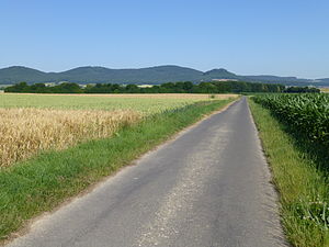
View from a road at the Hertingshausen grill hut (on the Hertingshausener Bach, near K 22) west-northwest to the Langenberg Mountains: Bensberg (left), Laufskopf (center left), Schwengeberg (center right) and Burgberg (right) |
||
| height | 464.8 m above sea level NHN | |
| location | near Ermetheis , Schwalm-Eder-Kreis , Hesse ( Germany ) | |
| Mountains |
Langenberg / e , Habichtswälder Bergland |
|
| Coordinates | 51 ° 13 '56 " N , 9 ° 21' 9" E | |
|
|
||
The Bensberg is 464.8 m above sea level. NHN high elevation in the main ridge of the Habichtswälder Bergland and extensively wooded Langenberge in the north Hessian Schwalm-Eder district .
geography
location
The Bensberg is located in the Habichtswald Nature Park and is part of the main ridge of the Langenberge, which includes Schwengeberg ( 556.7 m ), Laufskopf ( 534.8 m ) and Bilstein (approx. 460 m ). It rises between the villages of Ermetheis (to Niedenstein ) in the west, Besse (to Edermünde ) in the east-southeast and Grossenritte (to Baunatal in the neighboring district of Kassel ) in the northeast. Its summit is a few meters west of the municipal boundary of Gudensberg and Edermünde in the Gudensberg area, to which the western slope also belongs; its eastern slope belongs to the municipality of Edermünde.
The neighbor is the approximately 650 m south-southeast located Bilstein, and 1.1 km northwest is the Laufskopf. The 3219 state road leads between Ermetheis and Großenritte over the mountain saddle leading to the Laufskopf. The Langenbergrennen used to end at the Bensberg hikers' car park there .
Natural allocation
The Bensberg belongs to the natural spatial main unit group West Hessisches Bergland (No. 34), in the main unit Habichtswälder Bergland (342) and in the subunit Habichtswald (with Langenberg) (342.0) to the natural area Langenberg (342.02). The landscape falls to the southwest into the natural area Fritzlarer Börde (343.23 ), which is part of the subunit Hessengau (343.2) , and to the east into the subunit Kassel Basin (343.3), both of which are part of the main unit West Hessian Basin (343).
Flowing waters
To the west of the Bensberg lies the source of the small Elsterbach, whose water flows through the Matzoff, which ultimately strives south-west, to the Eder tributary of the Ems . The Pilgerbach rises to the east and flows eastward into the Fulda tributary Eder. A little further north, the Leisel rises on the Laufskopf , the water of which reaches the Fulda directly through the Bauna .
Individual evidence
- ↑ a b Map services of the Federal Agency for Nature Conservation ( information )
- ^ Hans-Jürgen Klink: Geographical land survey: The natural space units on sheet 112 Kassel. Federal Institute for Regional Studies, Bad Godesberg 1969. → Online map (PDF; 6.9 MB)
Web links
- Langenberge: Bensberg , map with the geographical location of the Bensberg, on opencaching.de

