Powiat Nowosądecki
| Powiat Nowosądecki | |
|---|---|

|

|
| Basic data | |
| State : | Poland |
| Voivodeship : | Lesser Poland |
| County town : | Nowy Sącz |
| Area : | 1550.24 km 2 |
| Residents : | 200,590 (June 30, 2008) |
| Telephone code : | (+48) 18 |
| License plate : |
KNS
|
| Circle structure | |
| Municipalities : | 1 |
| Urban and rural communities : | 4th |
| Rural communities : | 11 |
| Starostei (as of 2007) | |
| Starost : | Jan Golonka |
| Address: | ul. Jagiellońska 33 33-300 Nowy Sącz |
| Website : | www.sacz.pl |
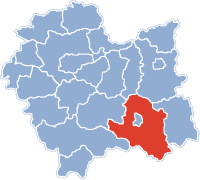
The powiat Nowosądecki is a powiat (district) in the south-eastern part of the Polish Lesser Poland Voivodeship . It is surrounded by the Powiats Nowy Targ , Limanowa , Brzesko , Tarnów and Gorlice and borders Slovakia in the south . The highest point of the powiat is the mountain Radziejowa with 1266 or 1262 m npm height.
The powiat encloses the district town Nowy Sącz , which does not belong to it. It is a city "with the rights of a powiat " (independent) .
coat of arms
Description : The split coat of arms is divided into red and gold five times at the front and has three rows in red with three golden six-pointed stars each .
Communities
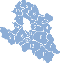
The district comprises 16 municipalities , including one urban municipality (gmina miejska) , four urban-and-rural municipalities (gmina miejsko-wiejska) and eleven rural municipalities (gmina wiejska) . The places Grybów , Krynica-Zdrój , Muszyna , Piwniczna-Zdrój and Stary Sącz have city rights.

|
|---|
Boroughs
- Grybów (Grünberg) (3)
Urban-and-rural parishes
- Krynica-Zdrój (7)
- Muszyna (11)
- Piwniczna-Zdrój (13)
- Stary Sącz (16)
Rural communities
- Chełmiec (1)
- Gródek nad Dunajcem (2)
- Grybów (4)
- Kamionka Wielka (5)
- Korzenna (6)
- Łabowa (8)
- Łącko (9)
- Łososina Dolna (10)
- Navojowa (12)
- Podegrodzie (14)
- Rytro (15).
Web links
Individual evidence
- ↑ Główny Urząd Statystyczny, “LUDNOŚĆ. STAN I STRUKTURA W PRZEKROJU TERYTORIALNYM ", as of June 30, 2008 ( Memento from January 29, 2009 on WebCite )
