Blato (Mikulovice)
| Blato | ||||
|---|---|---|---|---|
|
||||
| Basic data | ||||
| State : |
|
|||
| Region : | Pardubický kraj | |||
| District : | Pardubice | |||
| Municipality : | Mikulovice | |||
| Area : | 121 ha | |||
| Geographic location : | 49 ° 59 ' N , 15 ° 46' E | |||
| Height: | 240 m nm | |||
| Residents : | 228 (2001) | |||
| Postal code : | 530 02 | |||
| License plate : | E. | |||
| traffic | ||||
| Street: | Medlešice - Staré Jesenčany | |||
| Railway connection: | Havlíčkův Brod – Pardubice | |||
| Next international airport : | Pardubice airport | |||
Blato (German Blatto ) is a district of the municipality of Mikulovice in the Czech Republic . It is located six kilometers south of the city center of Pardubice on the city limits and belongs to the Okres Pardubice .
geography
Blato is located by the Jesenčanský potok on the Heřmanoměstecká tabule ( Hermannstädtler Tafel ). On the eastern edge of the village, the state road I / 37 runs between Pardubice and Chrudim ; west of the village, the Havlíčkův Brod – Pardubice railway line . In the west rises the Mikulovický Kopec (276 m nm).
Neighboring towns are Nové Jesenčany and Jesničánky in the north, Dražkovice in the north-east, Mikulovice in the east, Vestec and Medlešice in the south-east, Markovice and Třibřichy in the south, Dřenice in the south-west, Čepí and Dubany in the west and Třebosice and Staré Jesenčany in the north-west.
history
Blato is an important archaeological site and there has been evidence of settlement in the area since the Neolithic . In the clay pit of the brickworks and on the left side of Jesenčanský potok, flint stones , stone axes , ceramic vessels, squat and urn graves with additions, and storage and waste pits were found in the course of the 20th century . The last rescue excavation took place in 2004 before the construction of State Road I / 37. The most important find is an almost complete woolen rhinoceros skeleton , which was found in brick clay in 1900 and then exhibited in the National Museum.
The first written mention of Blato took place in 1382. Since the 16th century the estate belonged to the Lords of Bubna and Lititz , who in 1725 connected it to the Senftenberg estate and the Allodialgut Weywanowitz . In the judicial appraisal of the Daudleb rule in 1798, the land-use Blatto estate had a value of almost 22,300 guilders. After the death of Count Franz Adam von Bubna and Lititz in 1809, his son Franz took over the Blatto estate as a Fideikommisserbe.
In 1835, the in included Chrudim District Fideikommissgut located Blatto to which only the village of the same name belonged to a floor space of 176 square fathoms yoke 264. The village of Blatto or Blato consisted of 38 houses in which 247 people, including two Jewish families, lived. Two of the houses belonged to the Pardubice rule. The main source of income was agriculture and animal husbandry, and 24 traders were registered. In the village there was an inn, an official brandy house and a mill. The Chrudim magistrate took care of the official business of the estate . The parish was Mikolowitz , 9 houses were parish to Třebositz . Blatto remained a country estate until the middle of the 19th century .
After the abolition of patrimonial Bláto formed from 1849 a district of the municipality Medlešice in the judicial district of Chrudim . From 1868 the village belonged to the Chrudim district . Between 1868 and 1871 the Deutschbrod – Pardubitz railway line was laid out, but it passed Blato without stopping. In 1869 Blato had 329 inhabitants. At the end of the 19th century, Blato broke away from Medlešice and formed its own community. The volunteer fire department was founded in 1897. In 1898 a brick factory with a ring kiln was founded , it was gradually expanded and had 150 employees in its heyday. In 1900 there were 418 people living in the community, ten years later there were already 548. In 1930 Blato had 499 inhabitants. 1960 Blato was assigned to the Okres Pardubice. In 1964 it was incorporated into Mikulovice. The brick factory was closed in 1994. From 2004 the new state road I / 37 was built east of the village.
Local division
The district Blato consists of the basic settlement units Blato and U chrudimské silnice. The district forms a cadastral district.
Attractions
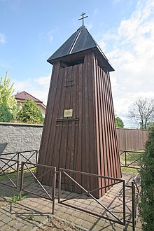
- Wooden bell tower, it was renewed in 1920, 1947 and 2003
literature
- Historický lexikon obcí České republiky 1869–2005 , part 1, p. 524
Web links
- Blato April 21, 2007 in pardubice.rozhlas.cz
Individual evidence
- ↑ http://www.uir.cz/katastralni-uzemi/694363/Blato
- ^ Johann Gottfried Sommer : The Kingdom of Bohemia; Represented statistically and topographically. Volume 5: Chrudimer Kreis. Prague 1837, pp. 15-16
- ↑ http://www.uir.cz/zsj-casti-obce/094366/Cast-obce-Blato


