
Boschetsrieder Strasse
| Boschetsrieder Strasse | |
|---|---|
|
|
|
 |
|
| View in east direction towards the elementary school | |
| Basic data | |
| State capital | Munich |
| Borough | Thalkirchen-Obersendling-Forstenried-Fürstenried-Solln |
| Name received | 1901 |
| Connecting roads | Fürstenrieder Strasse |
| Cross streets | Plinganserstraße, Wolfratshauser Straße , Kleinstraße, Tölzer Straße, Waakirchnerstraße, Baierbrunner Straße, Geretsrieder Straße, Hofmannstraße, Aidenbachstraße, Steinmetzstraße, Halskestraße, Schuckertstraße, Geisenhausener Straße, Ramsauer Straße, Machtlfingerstraße, Eleonore-Romberg-Straße, Listseeweg, Allee, Possenhofener Straße, A 95 junction |
| Places | Albert-Bayerle-Platz, Ratzingerplatz |
| Numbering system | Orientation numbering |
| use | |
| User groups | Pedestrian traffic , bicycle traffic , individual traffic , public transport |
| Technical specifications | |
| Street length | 3.2 km |
The Boschetsrieder road is a city road in the Munich districts Thalkirchen , Obersendling and Forstenried / Am Waldfriedhof, of the Federal Highway 11 (Plinganser- / Wolfratshauser road ) on the Isar -Hangkante west to Kreuzhof passes where they from the Fürstenriederstraße continued becomes. It is part of the Outer Ring and the Outer Radlring .
Development
For the expansion of the Obersendling industrial area of the Isarwerke in 1899, the board of the Munich city expansion department Theodor Fischer designed a road network. An unpaved and nameless path that led north of the industrial site from the edge of the Isar slope west to Fürstenried was expanded and named in 1901 after the former Hofmark Poschetsried . Poschetsried, also Boschetsried, emerged from the clearing of a freeman named Barschalk in the early 10th century and has been in the von Hörwarth family since 1593. From 1703, the latter renewed the seat there, which later became Fürstenried Castle of the Wittelsbach family .
The eastern end of Boschetsrieder Straße between the slope edge and the Maximiliansbahn was to be built with residential houses for the workers of the industrial area. In advance, the architect Robert Rehlen built an elementary school in a compact Art Nouveau style in 1903/04 in a largely free field . In accordance with the pedagogical and social concept of the city school councilor Georg Kerschensteiner , the school was equipped with classrooms and rooms for technical training and with facilities for the whole neighborhood. So shower baths , a children's sanctuary and a social station were integrated into the school building. Together with the school, Rehlen also built the neighboring fire station .
The construction of the workers' settlement was delayed, however, so that individual country houses and villas were created on Boschetsrieder Strasse; The construction of the first, mostly four-story apartment buildings did not begin until 1905, but these remained incomplete until the Second World War .
To the west of the railway underpass and as far as Ratzingerplatz at the intersection with Aidenbachstrasse, commercial and residential construction were mixed. The buildings of the largest Munich consumer cooperative in the southeast corner of Ratzingerplatz, which were badly damaged during the war and then demolished, were remarkable .
After the Second World War, vacant lots were closed, destroyed buildings replaced and the western part of the street was built on for the first time. Post-war architecture shapes the streetscape today. In 1952–54 the striking Siemens estate by architect Emil Freymuth was built on the north side of the western section . In the east, architect Walter Henn built a filigree factory hall on Tölzer Straße for the metal and precision engineering company Deckel AG in 1958-60 , both building complexes are listed. Also in the east, the Protestant Passion Church by architect Fritz Zeitler was built in 1968 from an emergency church built in 1933 . The Thomas-Mann-Gymnasium was built at the western end of the street in 1971/72 .

Primary school Boschetsrieder Straße

Former fire station Sendling

Landhaus Boschetsrieder Strasse 12, architect Max Littmann , 1898

Tenement house at Boschetsrieder Strasse 28, architect Carl Evora , 1912/13
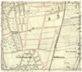
Planning of Boschetsrieder Straße, hand drawing by Theodor Fischer 1899


Transport and infrastructure
Boschetsrieder Strasse was initially only of local importance. That changed when a tram line branched off from Plinganserstraße in 1911 and ran under the railway line to Hofmannstraße. Line 8 operated, which became famous through the song of the same name by the popular singer Weiß Ferdl .
In 1946, the architect and town planning officer Karl Meitinger presented the Munich town council with an internally drawn up plan for the reconstruction of the town at the end of 1945, which also contained a chapter on arterial roads and ring roads. In it he developed the concept of a middle and an outer ring , both still within the urban area. Boschetsrieder Strasse was intended to be part of the Outer Ring.
In the course of the traffic expansion, Boschetsrieder Strasse was included in Munich's only trolleybus route from 1949 . A further expansion of this line over the edge of the slope into the Isar valley was still being structurally prepared, but operation on this line never came about.
In 1958 the Munich city council decided on a general transport plan, which was incorporated into the first Munich urban development plan of 1963. Accordingly, from 1964 the tram, now as line 16, was extended on Boschetsrieder Straße and continued to Fürstenried-West . It replaced the trolleybus, which was finally discontinued in 1966.
The street itself, which previously led in a uniform width to the Kreuzhof roundabout , was expanded to four lanes with a wide middle divider for the tram from Hofmannstraße and connected to the Garmisch Autobahn and Fürstenrieder Straße in the west at the Munich-Kreuzhof exit . In the corner between Boschetsrieder Straße and the motorway are the last remaining remains of the Sendlinger Forest, they were redesigned from 1960 to 1970 as the Südpark .
In 1967 the new fire station 2 of the Munich fire brigade was built in the northeast corner of Ratzingerplatz as a replacement for the too small building further east. The fire brigade school for the whole of Munich is located here. In 1991 the tram was also discontinued because the newly opened subway line 3 replaced it. This runs parallel to it a little south of Boschetsrieder Straße. The quarter is accessed through the three subway stations Obersendling , Aidenbachstrasse and Machtlfinger Strasse .
The systematic construction of the outer ring did not take place when, after protests against the renovation of the old town ring and the Isar parallel and extensive public participation , the concept of the car-friendly city as the sole model for urban development in Munich was abandoned from the mid-1960s . Therefore, the slope edge of the Isar valley was not expanded, at the intersection with the federal road 11 at the eastern end of Boschetsrieder Straße, the two-lane Greinerberg leads downwards as a one-way street and the much smaller Hoeckhstraße, which can only be driven on in a sharp curve at the foot, upwards.
Planning
By far the largest user of the Obersendling industrial area was the Hofmannstrasse location of Siemens AG . It was completely abandoned by the company around the turn of the millennium. In accordance with Munich's economic development, the areas will be built on with apartments. The large property on the corner of Boschetsrieder Strasse and Drygalski-Allee, which was intended for the headquarters of Bayernwerk and later E.ON , has also been built on with apartments since 2015. On the south side of Boschetsrieder Strasse, between Ratzingerplatz and Machtlfinger Strasse, there are other large Siemens buildings either vacant or inadequately used.
Ratzingerplatz is characterized by the area of the turning loop, which has not been used since the end of the tram, as well as by the oversized street areas with regard to traffic. In 2008, it was voted the “ugliest place in Munich” in a poll among readers of the Münchner Abendzeitung . In the course of the planning for the tram west bypass , the western part of Boschetsrieder Strasse is to be used again by trams. The planned final stop is the Aidenbachstraße underground station on Ratzingerplatz.
The former consumer property on the square, which had been fallow since shortly after the Second World War, is to be built with a school center by around 2020. The Ratzingerplatz itself will subsequently be redesigned by relocating all lanes to the south side. In the north of the square, another row development could then take place, which should close the image of the square.
literature
- Denis A. Chevalley, Timm Weski: State Capital Munich - Southwest (= Bavarian State Office for Monument Preservation [Hrsg.]: Monuments in Bavaria . Volume I.2 / 2 ). Karl M. Lipp Verlag, Munich 2004, ISBN 3-87490-584-5 , p. 122-127 .
Web links
Individual evidence
- ^ A b Hans Dollinger: The Munich street names . Südwest Verlag 2010, ISBN 978-3-517-08370-4 , p. 47
- ↑ For the last 500 meters before the Kreuzhof, the approximate middle of the street forms the border between the districts of Forstenried and Am Waldfriedhof.
- ↑ Denis A. Chevalley, Timm Weski: State Capital Munich - Southwest (= Bavarian State Office for Monument Preservation [Hrsg.]: Monuments in Bavaria . Volume I.2 / 2 ). Karl M. Lipp Verlag, Munich 2004, ISBN 3-87490-584-5 , p. 122 .
- ↑ Denis A. Chevalley, Timm Weski: State Capital Munich - Southwest (= Bavarian State Office for Monument Preservation [Hrsg.]: Monuments in Bavaria . Volume I.2 / 2 ). Karl M. Lipp Verlag, Munich 2004, ISBN 3-87490-584-5 , p. 192 .
- ^ Süddeutsche Zeitung: Cancellation prevented , October 29, 2015
- ^ Karl Meitinger: The New Munich - Suggestions for Reconstruction. Reprinted by the Bavarian State Office for Monument Preservation 2014, ISBN 978-3-86222-162-2 , pp. 37, 39–40
- ↑ Evening newspaper: Ratzingerplatz: The concrete desert should live , September 29, 2011
- ↑ Süddeutsche Zeitung: Sports lessons high above Ratzingerplatz , November 17, 2015
Coordinates: 48 ° 5 ′ 56 ″ N , 11 ° 31 ′ 10.9 ″ E