
Fürstenried West underground station
| Fürstenried West | |
|---|---|
|
|
|
 Fürstenried West |
|
| Basic data | |
| District | Fürstenried |
| Opened | June 1, 1991 |
| Tracks (platform) | 2 ( central platform ) |
| Coordinates | 48 ° 5 '18 " N , 11 ° 28' 51" E |
| use | |
| Stretch) | Trunk line 1 |
| Line (s) |
|
| Switching options |
|
The Fürstenried West subway station of the Munich subway was opened on June 1, 1991 and is the southern terminus of the U3.
The city limits are to the west near the train station, but further construction to Neuried is conceivable. The back track walls consist of bored piles that are interrupted by vertical yellow slats. The ceiling consists of rounded reflectors to which one light band is attached. The platform itself is designed with a triangular Isar pebble motif. It is about 10 meters below Neurieder Straße. There is a park-and-ride garage near the train station . Neurieder Straße and a bus station can be reached at the west end. At the eastern end you also get to Neurieder Straße. There is a pictorial representation of the Fürstenrieder Castle on a wall in the barrier floor .
On June 2, 1991, just one day after the terminal station opened, tram line 16 (Harras – Neurieder Straße) was shut down.
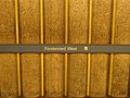
Station name on the back wall

Platform level 2018

Elevator on the platform level

Exit from the distribution level to the platform level

Fürstenried Castle as a pictorial representation

Access from the distribution level to the P + R facility

Surface access


| line | Line course |
|---|---|
|
|
Moosach - Moosacher St.-Martins-Platz - Olympia Shopping Center - Oberwiesenfeld - Olympiazentrum - Petuelring - Scheidplatz - Bonner Platz - Münchner Freiheit - Giselastraße - University - Odeonsplatz - Marienplatz - Sendlinger Tor - Goetheplatz - Poccistraße - Implerstraße - Brudermühlstraße - Thalkirchen - Obersendling - Aidenbachstrasse - Machtlfinger Strasse - Forstenrieder Allee - Basler Strasse - Fürstenried West |
credentials
See also
Web links
- Further information at www.u-bahn-muenchen.de
- Area map and further information about the train station at mvv-muenchen.de