
Braubach (Liederbach)
| Braubach | ||
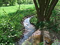
 Confluence with the Liederbach |
||
| Data | ||
| Water code | DE : 249236 | |
| location |
Taunus
|
|
| River system | Rhine | |
| Drain over | Liederbach → Main → Rhine → North Sea | |
| source | in the Vordertaunus , south of Königstein - Schneidhain 50 ° 10 ′ 13 ″ N , 8 ° 26 ′ 46 ″ E |
|
| Source height | approx. 300 m above sea level NHN | |
| muzzle | north of Kelkheim - Hornau within the Bad Soden -Altenhain district in the Liederbach Coordinates: 50 ° 9 ′ 17 ″ N , 8 ° 27 ′ 10 ″ E 50 ° 9 ′ 17 ″ N , 8 ° 27 ′ 10 ″ E |
|
| Mouth height | approx. 230 m above sea level NHN | |
| Height difference | approx. 70 m | |
| Bottom slope | approx. 33 ‰ | |
| length | approx. 2.1 km | |
The Braubach is a 2 km long, right and northwestern tributary of the Liederbach in the Hessian Hochtaunuskreis .
Surname
The part of the name “brew” may come from the ahd. Bri-uwan , bruwan, “brew”, meaning movement of a body of water .
geography
course
The Braubach rises in the Vordertaunus at an altitude of about 300 m above sea level. NHN south of the Königstein district of Schneidhain (between the railway embankment and the street Am Zankwald ).
The stream initially flows in a southerly direction, parallel to the Königsteiner railway line , through a narrow meadow valley. North of Rodenberg (height 300 m) are located on either side of its course barrows . This is also where the designated 3.65 hectare nature reserve Braubachtal near Hornau is located .
The Braubach runs west past the foot of the Rodenberg , flows through the Braubachweiher , a small fishing pond owned by ASV Kelkheim, and finally, coming from the northwest, flows north of the Kelkheim district of Hornau (still within the Bad Soden- Altenhain district) at an altitude of around 230 m above sea level NHN and from the right into the Liederbach approaching from the north .
Its 2.1 km long run ends about 70 meters below its source, so it has an average bed gradient of about 33 ‰.
Catchment area
The catchment area of the Braubach lies in the Voraunus and is drained to the North Sea via the Main and Rhine .
It borders
- in the north, east and south to that of the Liederbach
- and in the west to that of the Rettershofer Bach , which flows into the Fischbach and that of the Fischbach itself, which drains over the Schwarzbach into the Main.
The highest point is at 308.7 m above sea level. NHN the heath in the north of the catchment area.
Most of the catchment area is forested and grassland dominates in the estuary.
nature and environment
Water quality
The entire course of the Braubach is classified as moderately polluted ( quality class II ).
fauna
.jpg)
The Braubachtal is a biologically high-quality area in which wet and orchard meadows and hedges alternate with arable fields. There is also a forest area with old trees to the east of the Rodenberg . The valley is a very varied biotope in which many animal species live. There are also rare and endangered butterflies , reptiles , birds and small mammals .
Among other things, these are: dark green fritillary , Violet Waldbläuling , Great Purple Emperor , salamanders , grass snake , dipper , kingfisher , tawny owl , water shrew , field shrew , badger and hare
In Braubach Weiher live carp , rainbow trout , pike , perch , eel and whitefish .
Picture gallery

Braubachquelle (next to the railway embankment)

Braubach (upper course)
Braubach
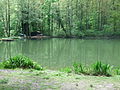
Fish pond in the Braubachtal

Braubach (shortly before the confluence with the Liederbach)


Individual evidence
- ↑ a b Topographic Map 1: 25,000 and Google Earth
- ↑ Water map service of the Hessian Ministry for the Environment, Climate Protection, Agriculture and Consumer Protection ( information )
- ^ Marieluise Petran-Belschner: The names of the waters of the Main-Taunus area
- ↑ Ordinance on the Braubachtal nature reserve near Hornau of July 14, 2000
- ↑ a b Braubachweiher , ASV Kelkheim eV 1979
- ↑ a b New construction of the B 8 bypass Königstein and Kelkheim (PDF; 1.6 MB) Explanatory report on the regional planning procedure, February 2006
- ↑ a b c notice board