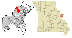
Bridgeton, Missouri
| Bridgeton | |
|---|---|
|
Location in Missouri
|
|
| Basic data | |
| State : | United States |
| State : | Missouri |
| County : | St. Louis County |
| Coordinates : | 38 ° 45 ′ N , 90 ° 25 ′ W |
| Time zone : | Central ( UTC − 6 / −5 ) |
| Residents : | 11,550 (as of 2010) |
| Population density : | 305.6 inhabitants per km 2 |
| Area : | 39.5 km 2 (about 15 mi 2 ) of which 37.8 km 2 (about 15 mi 2 ) are land |
| Height : | 178 m |
| Postal code : | 63044 |
| FIPS : | 29-08398 |
| GNIS ID : | 0755816 |
| Website : | www.bridgetonmo.com |
Bridgeton is a US city ( City ) in St. Louis County in Missouri with some 10,000 inhabitants.
The location in the northwest of the Airport Township around St. Louis Airport is the seat of the Trans States Airlines .
Other attractions in the city in the metropolitan region of Greater St. Louis is one of the the National Register of Historic Places listed Payne-Gentry House .
Personalities
- Janet Jones (born 1961), actress
Web links
Commons : Bridgeton, Missouri - collection of pictures, videos, and audio files
