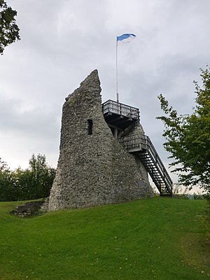
Eversberg Castle
| Eversberg Castle | |
|---|---|
|
The ruins of Eversberg Castle |
|
| Creation time : | 1093 to 1124 (probably around 1242) |
| Castle type : | Hilltop castle |
| Conservation status: | Bergfriedstump, small remains of the wall |
| Standing position : | Count |
| Place: | Meschede - Eversberg |
| Geographical location | 51 ° 21 '42 " N , 8 ° 20' 3" E |
| Height: | 453 m above sea level NHN |
The ruins of Eversberg Castle are located in the Arnsberg Forest Nature Park at 453 m above sea level. NHN high Schlossberg, which rises above the Ruhr valley on the southern edge of Eversberg , a district of Meschede in the North Rhine-Westphalian Hochsauerlandkreis .
history
Allegedly an otherwise intangible Count Eberhard von Arnsberg had the hilltop castle built between 1093 and 1124. It was destroyed by fire in 1235 and under Count Gottfried III. von Arnsberg finally rebuilt to secure its territory against Kurköln . Here he founded the town of Eversberg in 1242 and granted it the town charter of Lippe .
The structure fell into disrepair since the 16th century, and the stump of the keep with a recently built wooden viewing platform and small remnants of walls have been preserved.
From the platform, which is about 7.5 m high, there is a very good all-round view of Eversberg in the north, the Ruhr valley in the south and the surrounding mountains of the Sauerland .
literature
- Jens Friedhoff : Sauerland and Siegerland. Theiss Castle Guide . Edited by Joachim Zeune . Theiss, Stuttgart 2002, ISBN 3-8062-1706-8 , p. 57.
Web links
- Eversberg castle ruins
- 360 ° panorama picture of Eversberg Castle in the Westphalian Cultural Atlas (requires Flash player )
Individual evidence
- ↑ Map services of the Federal Agency for Nature Conservation ( information )
- ↑ According to private measurements


