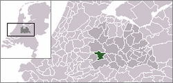
Montfoort
 flag |
 coat of arms |
| province |
|
| mayor | Petra van Hartskamp-de Jong ( VVD ) |
| Seat of the municipality | Montfoort |
|
Area - land - water |
38.2 km 2 37.57 km 2 0.63 km 2 |
| CBS code | 0335 |
| Residents | 13,980 (Jan 31, 2019) |
| Population density | 366 inhabitants / km 2 |
| Coordinates | 52 ° 3 ' N , 4 ° 57' E |
| Important traffic route |
|
| prefix | 0348 |
| Postcodes | 3417, 3461 |
| Website | Homepage of Montfoort |
Montfoort ( ) is a municipality in the Dutch province of Utrecht in the Lopikerwaard polder . The town of Montfoort was the residence of the Burgraves of Montfoort between the 12th century and 1672 .
Location and economy
Montfoort is located in the southwest of the province of Utrecht in a picturesque polder landscape. It is 8 km from the nearest motorway, the A12 Utrecht - The Hague . The nearest train stations are Utrecht CS and Woerden .
The population lives from agriculture, the related trade and small businesses and, increasingly, from tourism. Many residents commute to work in the city of Utrecht every day.
Districts
- The small town of Montfoort, seat of the municipal administration.
- The village of Linschoten .
- The hamlets of Achthoven-West, Achthoven-Oost, Blokland, Cattenbroek, Mastwijk and Willeskop.
history
Around 1170, the area of the current municipality of Montfoort was first settled around a castle of the same name. The name comes from the Latin "Mons Fortis", which means "strong mountain". The lords of the castle from the De Rover family, who operated under the name of Van Montfoort , were burgraves who exercised considerable power in the area. The settlement around the Castle received in 1329 the town charter . There were regular conflicts with the sovereign, the Utrecht bishop . That led u. a. in 1387 to a siege and capture of Montfoort by the bishop's troops. In the meantime , four gentlemen had built their own castle in the area of Linschoten, which was first mentioned in 1172 , and farmers had bought a piece of marshland from the sovereign, which after they had reclaimed it became their property. Such a contract was called - like the newly won land - a cope (Dutch: koop; German: purchase). Place names like Willeskop still remind of this.
In 1544 the Order of St. John founded a commanderij ( Coming ) with a church here: See the Maltese cross in the city flag. The town of Montfoort came into conflict with the burgrave at the end of the 16th century when the town declared its support for the Reformation but the burgrave remained Catholic.
In 1629, Montfoort was almost completely destroyed by a huge fire; In 1634 the (now Protestant) church was reopened. The last burgrave had to resign in 1648 because he was bankrupt. In 1672 , when Holland was attacked by the French, they burned u. a. the Montfoort Castle. After that, the Montfoorters struggled through the 18th and 19th centuries; one lived u. a. from the manufacture of buttons and ropes for ships. The brick industry was later important.
Attractions
- IJsseltor, the only remaining city gate
- 17th century church
- Remnants of the commanderij der Johanniter
- narrow road along the Linschoten river with the many picturesque farms that characterize the village of Linschoten
- Polder landscape with some of the typical Dutch windmills, very suitable for a bike ride
Sons and daughters of the place
- Lambertus Hortensius (around 1500–1574), humanist and clergyman
- Isbrand van Diemerbroeck (1609–1674), medic
- Matthew Maty , medical doctor, biographer, and librarian
Allocation of seats in the municipal council (2010)
- Progressive accord, 3 seats
- Leefbaar Montfoort, 4 seats
- CDA , 3 seats
- VVD , 2 seats
- D66 , 1 seat
- CU , 1 seat
- SGP , 1 seat
Web links
- Website of the municipality (Dutch)
Individual evidence
- ↑ Bevolkingsontwikkeling; regio per maand . In: StatLine . Centraal Bureau voor de Statistiek (Dutch)


