
Houten
 flag |
 coat of arms |
| province |
|
| mayor | Gilbert Isabella ( PvdA ) |
| Seat of the municipality | Houten |
|
Area - land - water |
55.49 km 2 58.76 km 2 3.49 km 2 |
| CBS code | 0321 |
| Residents | 49,900 (Jan 31, 2019) |
| Population density | 899 inhabitants / km 2 |
| Coordinates | 52 ° 2 ′ N , 5 ° 10 ′ E |
| Important traffic route |
|
| prefix | 030 |
| Postcodes | 3990-3999 |
| Website | Homepage of Houten |
 |
|
Houten ( ) is a municipality in the Dutch province of Utrecht . It is known as a bicycle city , as a traffic concept consistently designed for bicycles has been implemented in Houten .
places
- Houten, seat of the municipal administration
- Tull en 't Waal south of Houten (about 700 inhabitants)
- Schalkwijk east of Tull en 't Waal on the railway (about 2000 inhabitants)
- 't Goy east of Schalkwijk (about 600 inhabitants)
Location, transport and economy
Houten is on the Utrecht – Boxtel railway line . In Houten there was the shortest tram route in Europe at 1.9 km. She joined 2001-2008 as light rail Houten the station Houten with the station Houten Castellum. Two TW 6000 wagons, acquired second-hand from the Hanover Stadtbahn , were used on it.
On 24 August 2007, the reception building of Houtener station, which was being repaired, the railway line in the way, was lifted onto a rack, a few hundred meters shifted and then placed on a new foundation.
When expanding the community, care should be taken to ensure that cyclists are given preference over motorists. The traffic concept was developed in the 1970s by urban planner Robert Derks . Houten received star-shaped cycle paths with right of way. Cyclists can quickly reach the center of the municipality from their Wijken (districts). As a result, most of the trips in Houten are made by bike. Small electric scooters operate as mini- taxis on the bike paths. There is a “circular route” for drivers. This circular route must first be approached from every Wijk in order to reach the center and the other Wijken. As a result, the distances for bicycles are typically shorter than for car traffic. The roads that branch off from the circular route are called Inprikker .
As in Nieuwegein to the west, there are many commuters in Houten who work in Utrecht . There are several business parks in Houten.
history
The place where Houten is now was already inhabited in Roman times. Later on, Franconian farmers lived here .
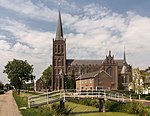
In the 12th century the construction of the later reformed church began. The towers were built from 1535 onwards. In the Middle Ages, the development of the village was concentrated around the church. The neo-Gothic Catholic Church Onze Lieve Vrouwe ten Hemelopneming (Assumption of Mary), designed by the architect Alfred Tepe between 1884 and 1885, was built at some distance from the Reformed Church .
The name Houten is derived from the word Haltna , which means place of residence in the bush or forest.
Heemstede Castle was built around 1645. In 1987 it was badly damaged by fire. It was restored around 1999–2002.
Houten was designated as a growth center in 1979 because of its location near the city of Utrecht and its rail connection to 's-Hertogenbosch . The area around Houten train station forms the new center of the community, while the “old village” is now a bit remote.
In the 1990s, a plan was presented according to which Houten should grow strongly. Ten new housing estates (ndl. Wijken), including the “Castellum” in the south, should be built in the near future. The municipality has 49,900 inhabitants (as of January 31, 2019).
Daughters and sons of the city
- Jan-Willem van Schip (* 1994), cyclist

Houten, street scene: Het Kant-Beekeepers

Houten, Heemstede Castle

Houten, steeple of the Reformed Church
Schalkwijk, church: de Sint Michaëlkerk


Web links
- Website of the municipality (Dutch)
Individual evidence
- ↑ Maarten Venderbosch: Gilbert Isabella geïnstalleerd as de nieuwe burgemeester van Houten. In: AD . De Persgroep Nederland , July 3, 2019, accessed July 4, 2019 (Dutch).
- ↑ Bevolkingsontwikkeling; regio per maand . In: StatLine . Centraal Bureau voor de Statistiek (Dutch)
- ↑ Jürgen Pander: Car-free districts: First everyone is against - and then for. In: Spiegel online. August 31, 2019, accessed September 4, 2019 .
- ^ Ludger Kazmierczak: Houten in the Netherlands: The car-free model city. In: Deutschlandfunk Kultur. November 7, 2017, accessed September 4, 2019 .
Amersfoort | Baarn | Bunnik | Bunschoten | De Bilt | De Ronde Veins | Eemnes | Houten | IJsselstein | Leusden | Lopik | Montfoort | Nieuwegein | Oudewater | Renswoude | Rhenen | Soest | Stings Vecht | Utrecht | Utrechtse Heuvelrug | Veenendaal | Vijfheerenlanden | Wijk bij Duurstede | Woerden | Woudenberg | Zeist