
Caminha
| Caminha | ||||||
|---|---|---|---|---|---|---|
|
||||||
| Basic data | ||||||
| Region : | Norte | |||||
| Sub-region : | Alto Minho | |||||
| District : | Viana do Castelo | |||||
| Concelho : | Caminha | |||||
| Coordinates : | 41 ° 53 ′ N , 8 ° 50 ′ W | |||||
| Residents: | 16,684 (as of June 30, 2011) | |||||
| Surface: | 136.53 km² (as of January 1, 2010) | |||||
| Population density : | 122 inhabitants per km² | |||||
| Caminha County | ||||||
|
||||||
| Residents: | 16,684 (as of June 30, 2011) | |||||
| Surface: | 136.53 km² (as of January 1, 2010) | |||||
| Population density : | 122 inhabitants per km² | |||||
| Number of municipalities : | 14th | |||||
| administration | ||||||
| Administration address: | Câmara Municipal de Caminha Praça Conselheiro Silva Torres 4910-122 Caminha |
|||||
| President of the Câmara Municipal: | Júlia Paula Costa ( PSD ) | |||||
| Website: | www.cm-caminha.pt | |||||


Caminha is a small town ( Vila ) and a district (Port. Município or Concelho ) in Portugal . The district has an area of 136.44 km² and has 16,684 inhabitants (as of June 30, 2011).

history
Finds (including Antas ) prove a prehistoric settlement of the area. The Romans who settled here also left traces, including bridges and sections of Roman roads . The place has been documented as Camenae or Camina since the 5th century AD . Ferdinand I (León) made the place in 1060 as Caput Mini the seat of a county. Even after the independence of the Kingdom of Portugal in 1139, Caminha remained important as a border town. King D Dinis expanded the town's fortification walls and gave Caminha its first town charter in 1284 . The strategic importance of the place lasted up to the 16th century, which received its development impulses in particular from fishing and trade by sea and river.
Culture and sights
The numerous architectural monuments in the district include archaeological finds and megalithic sites such as the Dólmen da Barrosa or the Dólmen de Santo Vile, a number of mansions and town houses, some stone fountains, historical public buildings and a large number of different sacred buildings . The historic town center as a whole is also a listed building. It is characterized by narrow streets with historical buildings. Its traffic-calmed center around the central Praça Concelheiro Silva Torres square with its New Manueline fountain and street cafes is now a major attraction for visitors.
With the art gallery Galeria de Arte de Caminha , the Galeria Guntilanis in Vila Praia de Âncora and the Galeria de Exposições for temporary exhibitions in the town hall building ( Câmara Municipal ), Carminha has several exhibition locations. The municipal library Biblioteca Municipal , the municipal archive Arquivo Municipal de Caminha , a toy library and various historical museums are other cultural institutions. The Museu Sidónio Pais is being planned .
Forte da Ínsua is located on the small island of Ínsua off Caminha, which belongs to the municipality of Moledo . The fortress was built from 1649 to 1652 after the island's monastery was pillaged by pirates several times. It has been a listed building since 1910.
The Festival de Vilar de Mouros has long been considered the most important rock festival in the country.
administration
circle

The district borders on Spain in the north . The neighboring areas are (starting clockwise in the north): Vila Nova de Cerveira , Ponte de Lima , Viana do Castelo , and the Atlantic Ocean.
With the regional reform in September 2013, several municipalities were merged into new municipalities, so that the number of municipalities decreased from 20 to 14.
The following municipalities ( freguesias ) are in Caminha County:

| local community | Population (2011) |
Area km² |
Density of population / km² |
LAU code |
|---|---|---|---|---|
| Âncora | 1,182 | 5.42 | 218 | 160201 |
| Arga (Baixo, Cima e São João) | 208 | 30.88 | 7th | 160221 |
| Argela | 393 | 10.80 | 36 | 160205 |
| Caminha e Vilarelho | 2,471 | 6.74 | 367 | 160222 |
| Dem | 363 | 6.43 | 56 | 160209 |
| Gondar e Orbacém | 435 | 11.06 | 39 | 160223 |
| Lanhelas | 991 | 5.04 | 197 | 160211 |
| Moledo e Cristelo | 1,566 | 10.36 | 151 | 160224 |
| Riba de Âncora | 723 | 8.54 | 85 | 160214 |
| Seixas | 1,502 | 8.33 | 180 | 160215 |
| Venade e Azevedo | 975 | 11.38 | 86 | 160225 |
| Vila Praia de Âncora | 4,820 | 8.37 | 576 | 160217 |
| Vilar de Mouros | 753 | 10.38 | 73 | 160218 |
| Vile | 302 | 2.80 | 108 | 160220 |
| Caminha County | 16,684 | 136.53 | 122 | 1602 |
Population development
| Population in Caminha County (1801–2011) | |||||||||||
|---|---|---|---|---|---|---|---|---|---|---|---|
| 1801 | 1849 | 1900 | 1930 | 1960 | 1981 | 1991 | 2001 | 2011 | |||
| 9251 | 12,167 | 15,288 | 15,810 | 16,688 | 15,883 | 16.207 | 17,069 | 16,684 | |||
,_2011._(5940090894).jpg)

Municipal holiday
- Monday after Easter Sunday
Town twinning
-
 France : Pontault-Combault in the canton of Pontault-Combault (since 1979)
traffic
The Caminha Railway Station is a stop on the railway line Linha do Minho . The national road N13 crosses the town, and the A28 motorway leads through the district with several exits . Caminha is integrated into the national bus network of Rede Expressos .
The municipal ferry from Caminha, Ferry-Boat Santa Rita de Cássia , runs daily from around 8:00 a.m. to around 8:00 p.m. (winter half-year around 6:00 p.m.) - provided the water level is sufficient, i. H. not at low tide - between Caminha and the Galician coastal town of A Guarda .
Sons and daughters

- Bento Maciel Parente (1567–1642), military and colonial politician in Brazil
- João Lourenço Rebelo (1610–1661), court composer
- Miguel Ventura Terra (1866-1919), architect
- Sidónio Pais (1872–1918), military, several times minister and republican head of government
- Domingos Fezas Vital (1888–1953), lawyer, university professor and politician in the Estado Novo regime
- Carlos Pinheiro (1925–2010), auxiliary bishop of the Archdiocese of Braga
- Quim Barreiros (* 1947), popular musician
- Henrique Baixinho (* 1961), Olympic rower
photos

Igreja Matriz de Caminha
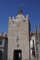
clock tower

The interior of the parish church

Minho river

In the historical center

In the historical center

The campsite of Caminha ( Camping Camarido )
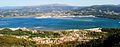
View from the north of Caminha (rear)


,_2011._(5939534877).jpg)


Web links
- Map of the Concelho Caminha at the Instituto Geográfico do Exército
- Official website
Individual evidence
- ↑ a b www.ine.pt - indicator resident population by place of residence and sex; Decennial in the database of the Instituto Nacional de Estatística
- ↑ a b Overview of code assignments from Freguesias on epp.eurostat.ec.europa.eu
- ↑ www.verportugal.net , accessed March 1, 2013
- ↑ www.monumentos.pt , accessed on March 1, 2013
- ^ Lydia Hohenberger, Jürgen Strohmaier: Portugal. 2nd edition, DuMont Reiseverlag, Ostfildern 2009, pp. 289f
- ↑ www.cm-caminha.pt ( Memento of the original from March 4, 2013 in the Internet Archive ) Info: The archive link was inserted automatically and has not yet been checked. Please check the original and archive link according to the instructions and then remove this notice. , accessed March 1, 2013
- ↑ www.verportugal.net , accessed March 1, 2013
- ↑ www.monumentos.pt , accessed on March 1, 2013
- ^ Publication of the administrative reorganization in the Diário da República gazette of January 28, 2013, accessed on March 16, 2014
- ↑ www.anmp.pt , accessed on March 1, 2013
- ↑ www.cm-caminha.pt ( Memento of the original from March 17, 2013 in the Internet Archive ) Info: The archive link was inserted automatically and has not yet been checked. Please check the original and archive link according to the instructions and then remove this notice. , accessed March 1, 2013

| ← Previous location: Viana do Castelo |
|
Next town: Vila Nova de Cerveira → |