Ponte de Lima
| Ponte de Lima district | |||||
|---|---|---|---|---|---|
|
|||||
| Residents: | 43,498 (as of June 30, 2011) | ||||
| Surface: | 320.27 km² (as of January 1, 2010) | ||||
| Population density : | 136 inhabitants per km² | ||||
| Number of municipalities : | 39 | ||||
| administration | |||||
| Administration address: | Câmara Municipal de Ponte de Lima Praça da República 4990-062 Ponte de Lima |
||||
| President of the Câmara Municipal: | Victor Mendes | ||||
| Website: | www.cm-pontedelima.pt | ||||
Ponte de Lima is a small town ( Vila ) and a district ( concelho ) in the northern Portuguese sub-region of Minho-Lima in the Viana do Castelo district . 44,343 inhabitants live in it (as of 2001) on 320.8 km².
history
Finds prove the settlement of today's district area since the Paleolithic . Remains of tombs ( antas and dolmen ) were found from the Neolithic Age . Tools have been found from the Bronze Age . However, significant excavations could not be made, and only the archaeological excavation of Wallburg Castro de S. Estêvão in the municipality Facha since 1979 brought more accurate findings. Further excavations confirmed an extensive settlement since the Iron Age , but the archaeological work has not progressed far enough to obtain a more precise picture of the situation in today's district.
From the 2nd century BC The area became Roman . A Roman road led over a local bridge over the Lima River , which subsequently increased its strategic importance. From the 5th century AD. Chr. Was the place part of the Visigoth kingdom and then was part of the municipality Agilde in the municipality ( "Pagus") Annove in Suebenreich . In the course of the subsequent Arab conquest from the early 8th century, the local population decreased significantly. In the course of the onset of the Reconquista , the area south of the Minho was under Alfonso III. repopulated by Asturias (866–910). Queen D. Teresa set up a number of new counties in County Portugal , including what is now the Ponte de Lima. In 1125 she gave the place town rights under its then name "Terra de Ponte" . The place received its first town charter ( Foral ) in the independent Kingdom of Portugal in 1212 by King D.Afonso IV .
Ponte de Lima remained of strategic importance even after the consolidation of Portugal, which had been independent since 1139, due to its proximity to the border and its bridge, and its city rights were renewed several times, for example in 1326 , 1332 and 1449 . In the 14th century, King Pedro I had the town fortified with city walls and nine city gates. The bridge originally built by the Romans was renewed and was considered the only safe crossing of the Lima.
King Manuel I had extensive renovation work carried out in the Vila (small town) and in 1515 renewed the town charter . In the course of the population growth and the increasing expansion of the place from the 18th century, a large part of the city wall was removed.
With the administrative reforms after the Miguelistenkrieg in the middle of the 19th century, a number of smaller circles were dissolved and incorporated into the Ponte de Lima district.
Culture and sights
The Museu dos Terceiros is housed in the former Santo António dos Frades monastery and adjacent buildings. The museum complex, which is laid out over two churches, a garden and a cloister and focuses on sculptures, especially from the 18th century, also shows sacred art since the Middle Ages. In 2007 it was reopened after extensive renovation and redesign. The Museu Rural Ponte de Lima deals with the rural traditions of the district, in particular the cultivation of maize and its characteristic traditional granaries, linen production, and viticulture, especially the vinho verde . The Museu do Brinquedo Português , opened in 2012, is a museum dedicated to the history of toys in Portugal since the 19th century.
The Festival de Ópera e Música Clássica de Ponte de Lima has been held every year since 2003 , a festival of classical music and opera, with performances in particular in the Teatro Diogo Bernardes, which opened in 1896 . The Festival Internacional de Jardins de Ponte de Lima takes place here every year from May to October , an international garden show that has been organized since 2005 with changing thematic orientations.
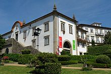
The numerous monuments in the district include historical public buildings and houses, Roman bridges, prehistoric excavations, and a large number of mansions and sacred buildings . The historic center as a whole is also a listed building in Ponte de Lima.
Sports
The sports club AD Limianos is particularly known for its professional football team, which plays in the third division (as of the 2018/2019 season). His roller hockey team should also be mentioned.

administration
circle
The seat of the district is in the eponymous place Ponte de Lima . The neighboring areas are (starting clockwise in the north): Paredes de Coura , Arcos de Valdevez , Ponte da Barca , Vila Verde , Barcelos , Viana do Castelo , Caminha and Vila Nova de Cerveira .
With the regional reform in September 2013 , several municipalities were merged into new municipalities, so that the number of municipalities decreased from 51 to 39.
The following municipalities ( Freguesias ) are in the Ponte de Lima district:
| local community | Population (2011) |
Area km² |
Density of population / km² |
LAU code |
|---|---|---|---|---|
| Anais | 1,073 | 8.06 | 133 | 160701 |
| Arca e Ponte de Lima | 3,756 | 4.01 | 938 | 160752 |
| Arcos | 640 | 15.05 | 43 | 160703 |
| Arcozelo | 3,734 | 12.08 | 309 | 160704 |
| Ardegão, Freixo e Mato | 1,754 | 10.72 | 164 | 160753 |
| Associação de Freguesias do Vale do Neiva | 1,075 | 10.27 | 105 | 160754 |
| Bárrio e Cepões | 921 | 9.71 | 95 | 160755 |
| Beiral do Lima | 558 | 7.32 | 76 | 160707 |
| Bertiandos | 414 | 2.27 | 183 | 160708 |
| Boalhosa | 163 | 2.19 | 75 | 160709 |
| Brandara | 442 | 2.58 | 172 | 160710 |
| Cabaços e Fojo Lobal | 951 | 9.27 | 103 | 160756 |
| Cabração e Moreira do Lima | 987 | 27.34 | 36 | 160757 |
| Calheiros | 991 | 8.50 | 117 | 160713 |
| Calvelo | 685 | 5.26 | 130 | 160714 |
| Correlhã | 2,936 | 8.66 | 339 | 160716 |
| Estorãos | 464 | 16.21 | 29 | 160717 |
| Facha | 1,529 | 15.31 | 100 | 160718 |
| Feitosa | 1,363 | 2.69 | 506 | 160719 |
| Fontão | 1.101 | 4.83 | 228 | 160721 |
| Fornelos e Queijada | 1.912 | 13.01 | 147 | 160758 |
| Friastelas | 450 | 3.92 | 115 | 160724 |
| Gandra | 1.108 | 3.49 | 318 | 160726 |
| Gemieira | 598 | 4.25 | 141 | 160727 |
| Gondufe | 450 | 5.57 | 81 | 160728 |
| Labruja | 439 | 14.56 | 30th | 160729 |
| Labrujó, Rendufe e Vilar do Monte | 417 | 11.26 | 37 | 160759 |
| Navió e Vitorino dos Piães | 1,768 | 13.60 | 130 | 160760 |
| Poiares | 775 | 7.44 | 104 | 160734 |
| Rebordões (Santa Maria) | 1,056 | 7.07 | 149 | 160744 |
| Rebordões (Souto) | 1,127 | 7.41 | 152 | 160747 |
| Refóios do Lima | 2,169 | 16.45 | 132 | 160737 |
| Ribeira | 1,902 | 8.77 | 217 | 160739 |
| Sá | 420 | 2.80 | 150 | 160740 |
| Santa Comba | 661 | 1.50 | 441 | 160742 |
| Santa Cruz do Lima | 480 | 2.23 | 215 | 160743 |
| Seara | 714 | 3.63 | 196 | 160745 |
| Serdedelo | 464 | 6.51 | 71 | 160746 |
| Vitorino das Donas | 1,051 | 4.47 | 235 | 160750 |
| Ponte de Lima district | 43,498 | 320.27 | 136 | 1607 |
Population development
| Population in the Ponte de Lima district (1801–2011) | ||||||||||
|---|---|---|---|---|---|---|---|---|---|---|
| 1801 | 1849 | 1900 | 1930 | 1960 | 1981 | 1991 | 2001 | 2011 | ||
| 13,202 | 29,869 | 33,314 | 36,256 | 42,979 | 43,797 | 43,421 | 44,343 | 43,498 | ||
Municipal holiday
- September 20th
Town twinning
-
 Spain : Xinzo de Limia (since 1984)
 -
 France : Châlette-sur-Loing in the canton of Châlette-sur-Loing (since 1988)
 -
 France : Vandœuvre-lès-Nancy (since 1989)
Sons and daughters
- Antônio Fernandes de Matos (1640–1701), builder, architect and entrepreneur in Brazil
- Cristóvão Pereira de Abreu (1678–1755), an important player in the colonial development of Brazil
- António de Araújo e Azevedo (1754–1817), scientist, diplomat and politician, multiple minister
- Francisco de São Luís Saraiva (1766–1845), Patriarch of Lisbon
- Francisco de Melo da Gama de Araújo e Azevedo (1773–1859), military and colonial administrator
- José Joaquim Marinho (1789–1858), surgeon, military and activist of liberalism
- António Feijó (1859–1917), diplomat and writer
- José Norton de Matos (1867–1955), military and politician
- Tomás Norton de Matos (1871–1943), doctor and Republican politician
- Teófilo Carneiro (1891–1949), writer and politician
- Aníbal Marinho (1902–1994), publicist, author, musician and opposition politician
- João Ricardo (* 1949), musician
- Fernando Pimenta (* 1989), canoeist, 2012 Olympic silver medalist
See also
Web links
- Map of the Concelho Ponte de Lima at the Instituto Geográfico do Exército
- Official website
- Old bridge from Ponte de Lima. In: Structurae
- New bridge from Ponte de Lima. In: Structurae
Individual evidence
- ↑ www.ine.pt - indicator resident population by place of residence and sex; Decennial in the database of the Instituto Nacional de Estatística
- ↑ Overview of code assignments from Freguesias on epp.eurostat.ec.europa.eu
- ↑ Data on the Ponte de Lima district ( en ) alea.pt. Archived from the original on December 19, 2015. Info: The archive link was automatically inserted and has not yet been checked. Please check the original and archive link according to the instructions and then remove this notice. Retrieved May 16, 2011.
- ^ History page of the district website , accessed February 26, 2013
- ↑ ditto
- ↑ verportugal.net , accessed on February 26, 2013
- ↑ www.cm-pontedelima.pt , accessed on February 26, 2013
- ↑ www.cm-pontedelima.pt , accessed on February 26, 2013
- ↑ www.monumentos.pt , accessed on February 26, 2013
- ^ Publication of the administrative reorganization in the Diário da República gazette of January 28, 2013, accessed on March 16, 2014
- ↑ www.anmp.pt , accessed on February 27, 2013
| ← Previous location: Barcelos |
|
Next town: Valença → |
Coordinates: 41 ° 46 ′ N , 8 ° 35 ′ W


