Arcos de Valdevez
| Arcos de Valdevez | ||||||
|---|---|---|---|---|---|---|
|
||||||
| Basic data | ||||||
| Region : | Norte | |||||
| Sub-region : | Alto Minho | |||||
| District : | Viana do Castelo | |||||
| Concelho : | Arcos de Valdevez | |||||
| Coordinates : | 41 ° 51 ′ N , 8 ° 25 ′ W | |||||
| Residents: | 22,847 (as of June 30, 2011) | |||||
| Surface: | 447.59 km² (as of January 1, 2010) | |||||
| Population density : | 51 inhabitants per km² | |||||
| politics | ||||||
| Address of the municipal administration: | Junta de Freguesia de Arcos de Valdevez Largo da Valeta, Nº 259 4970-467 Arcos de Valdevez |
|||||
| Website: | hosting.admdata.org/~jfavv/jfarcos/html/ | |||||
| Arcos de Valdevez district | ||||||
|
||||||
| Residents: | 22,847 (as of June 30, 2011) | |||||
| Surface: | 447.59 km² (as of January 1, 2010) | |||||
| Population density : | 51 inhabitants per km² | |||||
| Number of municipalities : | 36 | |||||
| administration | ||||||
| Administration address: | Câmara Municipal de Arcos de Valdevez Praça Município 4970 Arcos de Valdevez |
|||||
| President of the Câmara Municipal: | Dr. Franciso Rodrigues de Araújo | |||||
| Website: | www.cmav.pt | |||||
Arcos de Valdevez ( Portuguese : Arches of Valdevez, where Valdevez is an ancient name for Vale do Vez , German: Valley of the Vez River) is a small town ( Vila ) in Portugal with 22,847 inhabitants (as of June 30, 2011).
history
The place was founded in 350 BC. Chr. Of Celtiberians as Arcobriga founded. Finds, including tombs, actually prove the prehistoric settlement of the area up to the arrival of the Romans from the 2nd century BC. BC, who called the place Arcobrica . These established smaller fortifications in what is now the district area. The fertile soils and the numerous local watercourses remained attractions for settlements. The first communities arose here in the Middle Ages. In 1140 the armed forces of Alfonso VII (León) and the ruler of the Kingdom of Portugal , declared independent since 1139 , D.Afonso Henriques , met here . In order to avoid a battle, a knight tournament was held, from which the riders Dom Afonso Henrique emerged victorious, and he officially called himself King of Portugal from then on. Occasionally he is mentioned as the modern founder of the place.
King Manuel I gave the place city rights ( Foral ) under the name Terra do Valdovez in 1515 . In the course of the administrative reforms after the Liberal Revolution and the Miguelistenkrieg in the middle of the 19th century, the circle of Arcos de Valdevez experienced significant expansions.
Culture and sights
The district lies partly in the Peneda-Gerês National Park . Various hiking trails have been created, and a circular route through the town of Arcos de Valdevez along its monuments has been set up.
The architectural monuments of Arcos de Valdevez include, in addition to some historical bridges and buildings, archaeological excavations and stone fountains, above all a large number of mansions and sacred buildings . This includes some monasteries in the district, such as the Ermelo Monastery .
The historic town center as a whole is also a listed building, but despite everything, the place looks less romantic than comparable places.
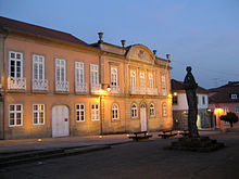
The Casa do Terreiro , a city palace from the 18th century, now houses the city museum and the city library. It is also the site of exhibitions and other activities and is therefore also called Casa das Artes (English: House of the Arts).
circle
administration
Arcos de Valdevez is the seat of a district of the same name, which borders on Spain to the east . The neighboring areas are (starting clockwise in the north): Monção , Melgaço , Ponte da Barca , Ponte de Lima and Paredes de Coura .
With the regional reform in September 2013, several municipalities were merged into new municipalities, so that the number of municipalities decreased from 51 to 36.

The following municipalities ( Freguesias ) are in the Arcos de Valdevez district:
| local community | Population (2011) |
Area km² |
Density of population / km² |
LAU code |
|---|---|---|---|---|
| Aboim das Choças | 333 | 1.83 | 182 | 160101 |
| Aguiã | 705 | 3.81 | 185 | 160102 |
| Álvora e Loureda | 456 | 10.24 | 45 | 160152 |
| Arcos de Valdevez e Giela | 1,661 | 5.52 | 301 | 160153 |
| Arcos de Valdevez, Vila Fonche e Parada | 2,580 | 5.27 | 489 | 160154 |
| Ázere | 247 | 3.18 | 78 | 160104 |
| Cabana Maior | 239 | 13.40 | 18th | 160105 |
| Cabreiro | 428 | 41.72 | 10 | 160106 |
| Cendufe | 360 | 3.16 | 114 | 160108 |
| Couto | 615 | 5.79 | 106 | 160109 |
| Eiras e Mei | 387 | 6.00 | 64 | 160155 |
| Gavieira | 298 | 57.71 | 5 | 160113 |
| Gondoriz | 958 | 33.97 | 28 | 160115 |
| Grade e Carralcova | 517 | 13.95 | 37 | 160156 |
| Guilhadeses e Santar | 1,283 | 3.91 | 328 | 160157 |
| Jolda e Rio Cabrão | 485 | 4.23 | 115 | 160158 |
| Jolda (S. Paio) | 360 | 1.70 | 212 | 160142 |
| Miranda | 325 | 10.02 | 32 | 160121 |
| Monte Redondo | 227 | 2.38 | 95 | 160122 |
| Oliveira | 330 | 3.21 | 103 | 160123 |
| Paçô | 933 | 4.60 | 203 | 160124 |
| Padreiro (Salvador e Santa Cristina) | 377 | 4.43 | 85 | 160159 |
| Padroso | 234 | 7.93 | 29 | 160125 |
| Portela e Extremo | 420 | 11.61 | 36 | 160160 |
| Prozelo | 943 | 3.96 | 238 | 160128 |
| Rio de Moinhos | 438 | 3.59 | 122 | 160131 |
| Rio Frio | 684 | 19.28 | 35 | 160130 |
| Sabadim | 468 | 8.33 | 56 | 160133 |
| São Jorge e Ermelo | 806 | 24.18 | 33 | 160161 |
| Souto e Tabaçô | 977 | 5.01 | 195 | 160162 |
| Senharei | 259 | 7.53 | 34 | 160144 |
| Sistelo | 273 | 26.23 | 10 | 160145 |
| Soajo | 986 | 59.10 | 17th | 160146 |
| Távora (Santa Maria e São Vicente) | 955 | 6.74 | 142 | 160163 |
| Vale | 776 | 15.12 | 51 | 160149 |
| Vilela, São Cosme e São Damião e Sá | 524 | 8.95 | 59 | 160164 |
| Arcos de Valdevez district | 22,847 | 447.59 | 51 | 1601 |
Population development
| Population in the Arcos de Valdevez county (1801 - 2011) | ||||||||
|---|---|---|---|---|---|---|---|---|
| 1801 | 1849 | 1900 | 1930 | 1960 | 1981 | 1991 | 2001 | 2011 |
| 21,435 | 25,824 | 31,968 | 32.163 | 38,739 | 31,156 | 26,976 | 24,761 | 22,847 |
Municipal holiday
- July 11th
Town twinning
-
 France : Dammarie-les-Lys (since 1999)
Sons and daughters
- Mariana Joaquina Pereira Coutinho (1748–1820), lady-in-waiting and literature patron
- Manuel Inácio de Melo e Sousa (1771–1859), politician in the Brazilian Empire
- Júlio Lima (1859–1942), industrialist and philanthropist
- Manuel António Gomes (1868–1933), called Padre Himalaya , clergyman, ecological inventor, a father of the modern use of solar energy
- António Pimenta Ribeiro (1901–1974), doctor and educator
- Leite de Vasconcelos (1944–1997), Mozambican writer and journalist
- Pedro Tiba (* 1988), football player
The writer Tomaz de Figueiredo (1902-1970) grew up in Arcos de Valdevez.
Web links
Individual evidence
- ↑ a b www.ine.pt - indicator resident population by place of residence and sex; Decennial in the database of the Instituto Nacional de Estatística
- ↑ a b Overview of code assignments from Freguesias on epp.eurostat.ec.europa.eu
- ^ João Fonseca: Dicionário do Nome das Terras. 2nd edition, Casa das Letras, Cruz Quebrada 2007, p. 36f ( ISBN 978-9724617305 )
- ↑ www.verportugal.net , accessed February 25, 2013
- ↑ www.monumentos.pt , accessed on February 25, 2013
- ^ Lydia Hohenberger, Jürgen Strohmaier: Portugal. 2nd edition, DuMont Reiseverlag, Ostfildern 2009, p. 289.
- ^ Publication of the administrative reorganization in the Diário da República gazette of January 28, 2013, accessed on March 16, 2014
- ↑ www.anmp.pt , accessed on February 25, 2013


