
Carta Marina


The Carta marina et descriptio septemtrionalium terrarum ac mirabilium rerum in eis contentarum diligentissime elaborata anno dni 1539 (" Nautical map and description of the Nordic countries and their wonders, carefully executed in the year of the Lord 1539") by Olaus Magnus is the earliest (by today's standards to some extent correct) map of Northern Europe and contains numerous details and location information, including a reference to the legendary Tile or Thule .
history
The map was made by the Swedish bishop Olaus Magnus in twelve years of work from 1527 to 1539 in Rome. Only a few maps of Scandinavia of earlier dates are known, such as that of Claudius Claussön Swart around 1427 and that of Jacob Ziegler from 1532. In addition to his own trips and the reports and maps of seafarers, these served as a model for Olaus Magnus , as did the Scandinavia map from the Cosmographia Claudii Ptolomaei Alexandrini published by Donnus Nicolaus Germanus in 1467 .
The name of the form cutter who cut the nine printing blocks in the format 56 × 41 cm is not known, but the influence of Jacopo Gastaldi can be seen . The first uncolored prints were made in Venice in 1539 . The Patriarch of Venice , Girolamo Querini, supported the company with 400 ducats, the publishing house was taken over by a Tommaso Rossi ( Thomas de Rubis ), who had his shop near the Rialto Bridge . Instructions for use in German and Italian were published at the same time as the card:
- A brief interpretation and elucidation of the new portfolios from the old kingdom of gods and other northern loins sampt with the underdeveloped things in the land and under the sea, understood in them, so clerically never intuition written. Vnd to praise and eer the kiinigkliche stat Danzig in Prayssen and gemainer use by Olaum Magnum Gotthum Lincopen. went out in Venice after the birth of Christ in 1539 .
- Opera breue, la quale demonstra, e dechiara, ouero da il modo facile de intendere la charta, ouer delle terre frigidissime di settentrione: oltra il mare germanico, doue si contengono le cose mirabilissime de quelli paesi, fin'a quest'hora non cognosciute , ne da greci, ne da latini.
In 1555, Olaus Magnus had his Historia de gentibus septentrionalibus , a description of the country of Scandinavia, printed as a commentary on the map .
Pope Paul III gave the card a ten-year printing privilege that prevented it from being copied and distributed. The Venetian government also issued a corresponding ordinance. These privileges are printed on the lower left of the card. Nevertheless, the card was not a commercial success, even if it was reprinted after the protection period had expired, with colored copies also being made. In 1572 Antonio Lafreri issued a copper engraving copy of about a tenth of the original size , of which a few have survived. In addition, the Carta Marina with its many details served as a model for Gerhard Mercator, among others . Several later maps of Iceland, such as the one in the Atlas Maior by Willem Janszoon Blaeu, are based on the Carta Marina.
The map was last mentioned in 1574 by Josias Simler . It was not until 1886 that the historian Oscar Brenner discovered a copy of the map in the Munich Court and State Library . A second specimen was discovered in Switzerland in 1961 and incorporated into the Carolina Rediviva collection of the Swedish University of Uppsala in 1962 . These two originals are not colored.
description
The card is 1.70 m wide × 1.25 m high. Due to its size, it was a wall map and not, as the current name Carta Marina suggests, a nautical map. Since it was not possible at the time to produce printed works of this size, the map was put together from nine individual prints, each 56 × 41 cm in size. The card is divided into 9 fields with the letters A to I using the printing blocks used.

The map shows (in a clock circle, starting at the top left) Iceland , Sweden , Norway , Finland , the Grand Duchy of Moscow , the Baltic States , Poland-Lithuania , the southern Baltic coast, Denmark , Scotland , the Orkney Islands , the Faroe Islands and Thule. In the center of the card is Scandia in large letters .
geography
Like the editions of Ptolemy maps in the 15th and 16th centuries, the Carta Marina is framed with the ancient climates , but a geographical network is not drawn. The latitudes range from 55 ° to the Arctic Circle , which Olaus Magnus gives as 90 °. It can be assumed that this frame was added to the map at a later date and was not used for its construction. Also indicate the length of the day.
There are several compass roses on the map . On one of them, a lily points slightly to the northeast, which shows that Olaus magnus already knew the difference between the North Pole and the Magnetic North Pole . The latter is located as a magnetic island ( insula magnetu (m) ) in Northern Lapland at the top right of the map. About it is reproduced in the context of the polus articus (North Pole).
The scale is indicated at the bottom right of the map , which is approx. 1: 2 million. The Italian, German and Swedish miles are shown under a circle in three columns .
Details
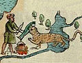
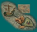
In addition to the landscape and localities, the map shows numerous details that depict the fauna and the way of life of the residents. All images are labeled with Latin texts. So you can see in Iceland volcanoes and polar bears on ice floes, but also the recovery of sulfur ( sulfur ). In Greenland ( Grutlandie ), which is shown in two parts east and west of Iceland, houses and boats of the Inuit are depicted. Sweden and Norway, which Olaus Magnus knew from his own travels, are illustrated in great detail. You can see reindeer in Lapland pulling sleds, moose fighting wolves, various species of animals, (ice) fishermen, boat builders and skiers, various hunting scenes in which a woman is also involved, and the trade in stockfish and furs. In addition to realistic scenes from nature and culture, there are also depictions from the world of legends: In a dominant position directly below the North Pole, next to pagans who worship the sun and fire and their nomad tents, the legendary hero Starkad is depicted. Like the biblical Moses , he is represented with two tablets in his hand. The inscription on the runic tablets is also given in Latin: starcatervs pvgil sveticvs = Starkad, the Swedish pugilist. On the one hand, it symbolizes Sweden's political and military claim to power, on the other hand, the tablets are supposed to prove that Sweden is an old cultural nation. The family tree of the ancient and legendary peoples at the bottom right who are said to have settled Scandinavia in prehistoric times conveys the same claim. Other unrealistic representations are probably based on stories told to Olaus Magnus: In Iceland, a man lures animals by playing the viol . In northern Russia, geese allegedly hibernate close together in the protection of bushes under piles of snow.

The magnetic north pole ( insula magnetu (m) ), in front of it the mythological Nordic hero Starkad

Reindeer pulling a sleigh, behind them soldiers on skis
Otters as fishing helper


On the Atlantic , the seafaring countries are each symbolized by a ship. In addition, the sea is populated by more or less fantastic creatures. A maelstrom near Lofoten off the Norwegian coast and wrecks off Iceland and Greenland indicate the dangerousness of seafaring. Clumps of ambergris swim in the sea and whaling is also shown.
English sailors ( Angli ) mistake a whale for an island.
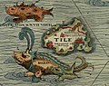
Wal ( balena ) and Orka ( Orcha ) Thule ( Tile )

Manatee ( vacca marina )
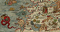
Maelstrom off the Norwegian coast, on land a devil sweeping the cattle shed

A Scottish ship is attacked by a Hamburg ship south of Iceland.


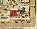
The political affiliation of each country is represented by coats of arms. The eight enthroned rulers of Scotland, England, Denmark, Norway, Sweden, " Gothia ", Poland-Lithuania and Moscow are each accompanied by a banner with a Bible verse that criticizes their conversion to the Reformation or praises their loyalty to Catholicism. Apart from the kings of Sweden ( Gustavus ) and Poland-Lithuania, whom Olaus Magnus must have known personally, they are only designated with their title and empire. Historical scenes include the armed conflicts of the Muscovites on the one hand with Sweden, including a battle on the frozen sea, and on the other hand with the Teutonic Order in the Baltic States. The Carta Marina also contains the oldest illustration of the Danewerk ( mvnvmentvum danavirke ).

The King of Norway

Battle on the ice between Sweden and the Muscovites

Denmark with the Danewerk and the kings of Denmark and Gothia
The coat of arms of the Magnus family.


There is also space for one's own family history: the coat of arms of Johannes Magnus , Archbishop of Uppsala who was expelled from Sweden by the Reformation in 1527 , whose brother and successor was Olaus Magnus in exile, is shown. The text next to it expressly states that Johannes Magnus is the rightful bishop. The coat of arms appears again in the lower right corner, this time expressly as a signature. The tied lion next to it represents the Swedish people put in chains by the Reformation introduced by Gustav Vasa. Olaus Magnus may have seen himself in the mouse, which according to the description can free the powerful but captive lion by gnawing He may have immortalized himself on his journey through the northern parts of the Scandinavian peninsula in 1518/19, on which he explored the country and its people, but also as the papal secretary, who is a snowshoe traveler who leads his horse through the mountains between Norway and Sweden Envoy Giovanni Angelo Arcimboldi fought against the spreading Lutheranism and sold indulgences.
literature
- Kurt Brunner: A map series of the Nordlande from 1539 . In: Deutsches Schiffahrtsarchiv, Zeitschrift des Deutschen Schiffahrtsmuseums, Bremerhaven, Vol. 12, 1998, pp. 173–194.
- Traudl Seifert: The card as a work of art. Decorative maps from the Middle Ages and modern times (exhibition catalogs / Bayerische Staatsbibliothek; 19). Uhl, Unterschneidheim 1979, pp. 24-28 No. 19 and Figure 16 ISBN 3-921503-55-8 .
- Olaus Magnus: The wonders of the north ( The Other Library , Vol. 261). Developed by Elena Balzamo and Reinhard Kaiser. Eichborn, Frankfurt am Main 2006, ISBN 3-8218-4571-6 .
Web links
- Digital copies of sheets A - I of the copy of the Bayerische Staatsbibliothek
- Carta Marina, Lafreris edition 1572 - Kungliga biblioteket. In: kb.se. Retrieved November 17, 2015 .
- Website about Olaus Magnus, with numerous illustrations of Carta marina (Engl.)
- detailed digitized original from Uppsala University
- Detailed digitization and information about the Carta Marina from the EU-funded CIPHER project ( Memento from February 7, 2012 in the Internet Archive )
- Carta marina . Publications in the bibliographic database of the Regesta Imperii .
Individual evidence
- ↑ https://www.lib.umn.edu/bell/maps/olausmagnus
- ↑ Carta Marina. Uppsala University, accessed April 3, 2018 .
- ↑ Kurt Brunner: A map series of the Nordlande from 1539 . In: Deutsches Schiffahrtsarchiv, Zeitschrift des Deutschen Schiffahrtsmuseums, Bremerhaven, Vol. 12, 1998, pp. 173–194; P. 176.
- ↑ Traudl Seifert: The map as a work of art. 1979, p. 28.
- ↑ This is evident from the note following the papal breve , the reference to the Venetian printing privilege and the Latin instructions for use by Olaus Magnus.
- ↑ Proof in EDIT16
- ↑ Proof in EDIT16; The publisher was Giovanni Tommaso from the Kingdom of Naples .
- ↑ Kurt Brunner: A map series of the Nordlande from 1539 . In: Deutsches Schiffahrtsarchiv, Zeitschrift des Deutschen Schiffahrtsmuseums, Bremerhaven, Vol. 12, 1998, pp. 173–194; P. 189f.
- ↑ Kurt Brunner: A map series of the Nordlande from 1539 . In: Deutsches Schiffahrtsarchiv, Zeitschrift des Deutschen Schiffahrtsmuseums, Bremerhaven, Vol. 12, 1998, pp. 173–194; P. 185.
- ↑ Detail Inuit
- ^ Inken Schmidt-Voges: "Et nos homines". Sweden as a frontier , in: Susan Richter, Michael Roth and Sebastian Meurer (eds): Constructions of Europe in the early modern period. Geographical and historical imaginations. Contributions to the 11th workshop “Global entanglements - Rethinking Europe” of the Early Modern Age Working Group in the Association of Historians of Germany September 17-19, 2015 in Heidelberg . Heidelberg 2017, pp. 41-88; P. 50.
- ↑ Detail music
- ↑ Detail geese
- ↑ Maike Sach: The pictorial representation of the Moscow Grand Duke on the Carta marina and the Historia de gentibus septentrionalibus of Olaus Magnus . In: "The shot from the picture" . For Frank Kämper on his 65th birthday. Ed. V. Klaus Topitsch u. Anke Brekerbohm. Munich 2004 (= Virtual Specialist Library for Eastern Europe, online: http://www.vifaost.de / Digital Eastern Europe Library: Series History, 11), pp. 123–136 [URL: http: //epub.ub.uni-muenchen .de / 558/10 / sach-grossfuerst.pdf ]; P. 127 (pdf, accessed January 8, 2020).
- ^ Inken Schmidt-Voges: "Et nos homines". Sweden as a frontier , in: Susan Richter, Michael Roth and Sebastian Meurer (eds): Constructions of Europe in the early modern period. Geographical and historical imaginations. Contributions to the 11th workshop “Global entanglements - Rethinking Europe” of the Early Modern Age Working Group in the Association of Historians of Germany September 17-19, 2015 in Heidelberg . Heidelberg 2017, pp. 41-88; P. 45.