Chilikadrotna River
| Chilikadrotna River | ||
|
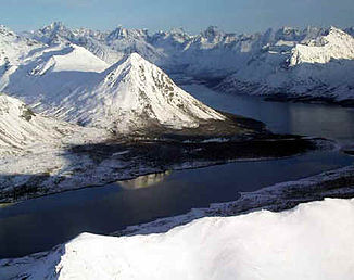
The Twin Lakes, headwaters of the Chilikadrotna River |
||
| Data | ||
| Water code | US : 1400287 | |
| location | Alaska (USA) | |
| River system | Nushagak River | |
| Drain over | Mulchatna River → Nushagak River → Bering Sea | |
| origin |
Twin Lakes lower lake 60 ° 39 ′ 58 ″ N , 154 ° 2 ′ 41 ″ W |
|
| Source height | 603 m | |
| muzzle |
Mulchatna River Coordinates: 60 ° 35 ′ 34 " N , 155 ° 23 ′ 32" W 60 ° 35 ′ 34 " N , 155 ° 23 ′ 32" W. |
|
| Mouth height | 259 m | |
| Height difference | 344 m | |
| Bottom slope | 3.8 ‰ | |
| length | 90 km | |
| National Wild and Scenic River | ||
The Chilikadrotna River is a 90 km long left tributary of the Mulchatna River in southwestern Alaska .
Its headwaters are the Twin Lakes in Lake Clark National Park . It flows westward and flows into the Mulchatna River.
The first 18 km of Chilikadrotna within the national park were designated by the Alaska National Interest Lands Conservation Act in 1980 as a National Wild and Scenic River under the administration of the National Park Service .
Individual evidence
- ↑ Twin Lakes in the Geographic Names Information System of the United States Geological Survey
- ↑ a b Chilikadrotna River in the Geographic Names Information System of the United States Geological Survey
- ↑ National Wild & Scenic Rivers - Chilikadrotna River ( Memento from June 10, 2010 in the Internet Archive )
