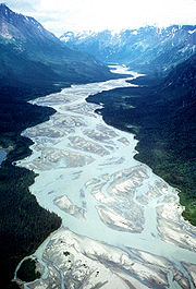
Tlikakila River
| Tlikakila River | ||
|
Tlikakila River in Lake Clark National Park |
||
| Data | ||
| Water code | US : 1414144 | |
| location | Alaska (USA) | |
| River system | Kvichak River | |
| Drain over | Newhalen River → Kvichak River → Bering Sea | |
| origin |
Summit Lake at Lake Clark Pass in the Chigmit Mountains 60 ° 47 ′ 6 ″ N , 152 ° 47 ′ 46 ″ W |
|
| Source height | 270 m | |
| muzzle |
Little Lake Clark Coordinates: 60 ° 23 ′ 31 " N , 153 ° 48 ′ 37" W 60 ° 23 ′ 31 " N , 153 ° 48 ′ 37" W. |
|
| Mouth height | 77 m | |
| Height difference | 193 m | |
| Bottom slope | 2.4 ‰ | |
| length | 80 km | |
| National Wild and Scenic River | ||
The Tlikakila River is an approximately 80 km long tributary of Little Lake Clark in southwest Alaska .
It rises from Summit Lake at Lake Clark Pass , flows southwest in a valley between the Neacola and the Chigmit Mountains and flows into Lake Clark . The river is fed by glaciers such as the Tanaina and Double glaciers . It is located in the Lake Clark Wilderness , a wilderness area within the Lake Clark National Park .
The Big River rises on the opposite, northeast side of Lake Clark Pass and flows into Redoubt Bay of the Cook Inlet . The Chokotonk River , which also flows into Lake Clark, flows in the neighboring valley of the lower reaches to the southeast .
The name is derived from the name of the Athabaskan Tanaina for the river.
The Tlikakila River was designated as a National Wild and Scenic River under the administration of the National Park Service in 1980 by the Alaska National Interest Lands Conservation Act .
Web links
Individual evidence
- ^ Summit Lake in the Geographic Names Information System of the United States Geological Survey
- ↑ Tlikakila River in the Geographic Names Information System of the United States Geological Survey
- ↑ a b National Wild & Scenic Rivers - Tlikakila River ( Memento from March 26, 2012 in the Internet Archive )
