Noatak River
| Noatak River | ||
|
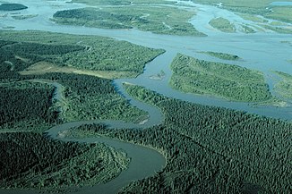
The Noatak River near its mouth south of Noatak |
||
| Data | ||
| Water code | US : 1418960 | |
| location | Alaska (USA) | |
| River system | Noatak River | |
| Headwaters | on Mount Igikpak in the Schwatka Mountains ( Brooks range ) 67 ° 22 ′ 44 ″ N , 154 ° 53 ′ 37 ″ W |
|
| Source height | approx. 1300 m | |
| muzzle |
Kotzebue-Sund , north of Kotzebue coordinates: 66 ° 58 '53 " N , 162 ° 30' 23" W 66 ° 58 '53 " N , 162 ° 30' 23" W |
|
| Mouth height | 0 m | |
| Height difference | approx. 1300 m | |
| Bottom slope | approx. 1.9 ‰ | |
| length | 675 km | |
| Catchment area | 31,080 km² (near Noatak) | |
| Discharge at the Noatak A Eo gauge: 31,080 km² Location: 105 km above the mouth |
MQ 1966/1966 Mq 1966/1966 |
258 m³ / s 8.3 l / (s km²) |
| Left tributaries | Cutler River , Eli River , Agashashok River | |
| Right tributaries | Aniuk River , Anisak River , Nimiuktuk River , Kugururok River , Kelly River | |
| Communities | Noatak | |
|
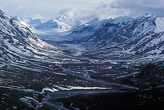
Upper course of the Noatak River in the Brook range |
||
The Noatak River is a 675 km long river in northwestern Alaska .
It rises on the slopes of Mount Igikpak in the Schwatka Mountains of the Brooks range in the Gates-of-the-Arctic National Park and flows north of Kotzebue at the exit of Hotham Inlet into Kotzebue Sound , a bay of the Chukchi Sea .
Most of the river's course lies in the Noatak National Preserve , the area of which corresponds to the catchment area of the river west of the national park. The Noatak River flows through these two protected areas except for the last few kilometers before its mouth. Parts of the catchment area at Kotzebue Sound, but not the river itself, are in the Cape Krusenstern National Monument . At 26,300 km², the Noatak River catchment area is the largest protected river system in the United States .
Protection status
In 1976 UNESCO designated the Noatak Biosphere Reserve . On December 2, 1980, the Alaska National Interest Lands Conservation Act declared 530 km from the source of the Noatak River to the mouth of the Kelly River in the Noatak National Preserve to be a National Wild and Scenic River under the administration of the National Park Service .
Flora and fauna

The vegetation at Noatak is determined by tundra and boreal coniferous forest in the river plains and alpine tundra with willows , heather , sour grass and mosses in the adjacent high areas. Cotton grasses , dwarf birches and alders can be found in the damp mountain foothills . Spruce forests are common throughout the region.
Caribou , elk , dall sheep , grizzly bears , wolves , foxes , lynxes , martens , beavers and muskrats live on the Noatak River. In the river itself and its tributaries there are large populations of arctic char and arctic grayling .
Web links
- National Park Service: Noatak National Preserve (official site; English)
- Noatak Wilderness (English)
- UNESCO Biosphere Reserve Noatak (English)
Individual evidence
- ↑ Noatak River in the Geographic Names Information System of the United States Geological Survey
- ↑ a b USGS 15746000 NOATAK R AT NOATAK AK
- ↑ National Wild & Scenic Rivers - Noatak River ( Memento from April 20, 2012 in the Internet Archive )

