Clemensberg
| Clemensberg | ||
|---|---|---|
|
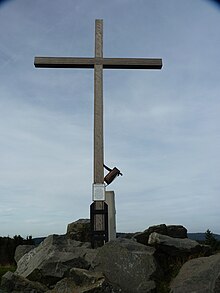
West summit of Clemensberg with a mountain cross and benches |
||
| height | 840 m above sea level NHN (overburden dome; originally 839.2 m, highest part still preserved approx. 837 m) | |
| location | near Hildfeld ; Hochsauerlandkreis , North Rhine-Westphalia ( Germany ) | |
| Mountains | Rothaar Mountains | |
| Dominance | 1.9 km → Hegekopf | |
| Notch height | 61 m ↓ to the Hegekopf | |
| Coordinates | 51 ° 15 '17 " N , 8 ° 34' 28" E | |
|
|
||
| Type | Hardling | |
| rock | Diabase | |
| particularities | Hochheide Neuer Hagen and summit that has been modified in terms of mining | |

The Clemensberg near Hildfeld in the Hochsauerland is a (including overburden) a good 840 m above sea level. NHN high mountain of the Rothaargebirge in the North Rhine-Westphalian Hochsauerlandkreis . The original mountain name - Die Steinert - is still used as a field name.
geography
location
The Clemensberg is located in the northern part of the Rothaargebirge east of the upper Ruhr valley, the bottom of which is almost 300 meters lower. Just outside the Sauerland-Rothaargebirge nature park , its summit rises directly north of Hildfeld , about 3 km east of Niedersfeld (both districts of Winterberg ), 5 km south-south-west of the center of the north Hessian community of Willingen and 2.5 km (depending on the beeline ) east of the bei Hillestausees located in Niedersfeld . Its ridge runs in a south-southwest-north-northeast direction.
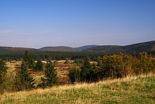
The protected high heath landscape of Neuer Hagen (also known as Niedersfelder Hochheide ) extends on the gently sloping slope of Clemensberg to the north . The Hoppecke spring lies in the eastern part , and the Itter rises on the eastern slope of the mountain range . Because the Clemensberg essentially of a 100 m thick diabase - bearing gear is established, the located on the steep southwestern flank Härtling a diabase quarry . A 500 m long ski lift has been built on the southern flank , the ski slope of which leads to Hildfeld. To the west of it there is still a trift path , over which the cattle were once driven from Hildfeld to the forest pasture and the high heath.
The neighboring mountains of Clemensberg include Langenberg ( 843.2 m ) in the north, Hegekopf ( 842.9 m ) in the northeast, Hopperkopf ( 832.3 m ) in the east-southeast and Rimberg ( 764.5 m ) in the west-southwest.
Natural allocation
The Clemensberg belongs to the natural spatial main unit group Süderbergland (No. 33) in the main unit Rothaargebirge (with Hochsauerland ) (333) and in the subunit Winterberger Hochland (333.5) to the natural area Langenberg (333.58). The landscape falls to the south into the natural area of Harfeld (333.56) and to the west into the natural area of Nordheller Höhen (333.57).
Mountain peak and mountain cross
The mountain used to be 839.2 m high. However, its former summit ( ⊙ ) has been and will be major parts of the mountain removed as part of the diabase mining, so that its highest unchanged part currently - east-northeast of the quarry - is only about 837 m high. The highest point created from overburden material as part of the recultivation plan currently measures a good 840 m .
On a cliff 60 m south-east of the original mountain summit, the Clemensberg summit cross made of wood, which was donated by a resident of Hildfeld, stood since 1946 . He had been a soldier in Italy during World War II and had vowed there that, if he returned home alive, he would erect a wooden cross on Clemensberg. After the summit had been dismantled, the cross was re-erected: it now stands about 450 m west of the former summit and 60 m south-east of a fork in the path at 835 m height at about 820 m ( ⊙ ) height - exposed on a recultivated overburden dome. 170 m northwest of the junction is another 825.5 m high knoll.
Hiking and viewing opportunities
North past the mountain summit of Clemensberg and the mountain cross - between the Rothaarsteighütte to the west and the eastern border with Hesse - the Rothaarsteig is a long-distance hiking trail that also leads through the Neuer Hagen . The mountain is - next to the 841.9 m high Kahler Asten - one of the few largely forestless and therefore promising peaks of the Rothaargebirge. From the mountain cross you can especially enjoy the view towards the southwest, across the Harfeld natural area to the Rothaarkamm, the elongated main ridge of the mountains.
Individual evidence
- ↑ a b c d e f Topographical Information Management, Cologne District Government, Department GEObasis NRW ( information )
- ↑ Martin Bürgener: Geographical Land Survey: The natural spatial units on sheet 111 Arolsen. Federal Institute for Regional Studies, Bad Godesberg 1963. → Online map (PDF; 4.1 MB)
- ↑ Land survey office of North Rhine-Westphalia: cadastral map, 1: 5000, 4717/13 Hegekopf (Kr. Waldeck) (R3470232, H5680044): height information "839.21" (m)
- ↑ a b Photo of the Clemensberg summit cross sign ( Memento of the original from March 4, 2016 in the Internet Archive ) Info: The archive link was inserted automatically and has not yet been checked. Please check the original and archive link according to the instructions and then remove this notice. , on gartenchaos.net
Web links
- View from Clemensberg to the south (labeling of visual targets can be activated), on panorama-photo.net


