Czerniejewo
| Czerniejewo | ||
|---|---|---|

|
|
|
| Basic data | ||
| State : | Poland | |
| Voivodeship : | Greater Poland | |
| Powiat : | Gniezno | |
| Area : | 10.20 km² | |
| Geographic location : | 52 ° 26 ' N , 17 ° 29' E | |
| Height : | 100 m npm | |
| Residents : | 2666 (June 30, 2019) |
|
| Postal code : | 62-250 | |
| Telephone code : | (+48) 61 | |
| License plate : | PGN | |
| Economy and Transport | ||
| Street : | Nekla - Gniezno | |
| Next international airport : | Poznań-Ławica | |
| Gmina | ||
| Gminatype: | Urban and rural municipality | |
| Gmina structure: | 14 school offices | |
| Surface: | 112.01 km² | |
| Residents: | 7361 (June 30, 2019) |
|
| Population density : | 66 inhabitants / km² | |
| Community number ( GUS ): | 3003023 | |
| Administration (as of 2015) | ||
| Mayor : | Tadeusz Szymanek | |
| Address: | ul.Poznańska 8 62-250 Czerniejewo |
|
| Website : | www.czerniejewo.pl | |
Czerniejewo ( German Schwarzenau , formerly Tscherniejewo ) is a city in the Polish Voivodeship of Greater Poland .
Geographical location
The city is located on the Wrześnica River ( German Wreschnitza ), about 38 kilometers east of the city of Poznan .
history

In the 11th century there was a trading center on the site of today's Czerniejewo. The first written mention comes from the year 1284 . Until 1386 the place belonged to the royal estates, then it went to Sędziwój Paluka z Szubina . It is no longer known exactly when the settlement received city rights , as the relevant documents have been lost, but the city elevation took place between 1386 and 1390 under Magdeburg law . In the 16th century the Górka owned the village. Stephan Báthory approved in a document dated March 30, 1581 the place to be allowed to hold annual markets . The Reformation arrived and the Protestants built a church.
Around 1780 General Jan Lipski , meanwhile owner of the place, had a palace built here. At the end of the 18th century the city had three churches, a public building, 98 houses, six mills and 787 inhabitants, including 147 Jews. Half of the residents were Poles . By marrying a Lipski, the village came to a Skorzewski in the 19th century.
During the second partition of Poland-Lithuania , Czerniejewo fell to Prussia in 1793 . After the Peace of Tilsit , the place came to the newly formed Duchy of Warsaw in 1807 and remained there until its dissolution in 1815. The Congress of Vienna returned the city to the Kingdom of Prussia. During the Wielkopolska Uprising in 1848, Polish insurgents took control of the city, barricaded the entrances and began demolishing the river bridge. In April General von Hirschfeld had the uprising ended by firing four warning shots from artillery guns. The city was occupied by Prussian troops and the bridge was repaired.
In 1875 it was connected to the rail network of the Prussian state railway.
By the end of the First World War , the city had to County Witkowo in the administrative district of Bromberg of the Prussian province of Posen heard.
In 1918/1919 the Polish population group of the place took part in the Wielkopolska uprising . Due to the provisions of the Versailles Treaty , the city had to be ceded to the Second Polish Republic in 1920.
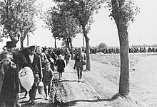
At the beginning of the Second World War , Czerniejewo was incorporated into the Reich in violation of international law when the German Wehrmacht invaded Poland . The Polish population was evacuated in 1939. The district with the city was incorporated into the Reichsgau Wartheland , to which it belonged until 1945.
Towards the end of World War II, the Red Army occupied the region in January 1945 . Shortly thereafter, the city was handed over to the administration of the People's Republic of Poland . In the subsequent period, the members of the German minority in the city were sold .
In the course of the reorganization of the voivodeships, the place became part of the newly formed Poznan Voivodeship in 1975 and part of the Greater Poland Voivodeship in 1999 .
Population numbers
- 1800: 787, half of them Poles, including 147 Jews
- 1816: 870, in only 85 households, including 440 Catholics, 212 Evangelicals and 216 Jews
- 1837: 1.188
- 1843: 1,297
- 1858: 1,213
- 1861: 1.302
- 1885: 1.480
Economy and Infrastructure
traffic
The city is not on any major road. The national road 434 runs about seven kilometers west seven kilometers east which runs the country Straße 15 . The European route 261 runs nine kilometers north, the European route 30 nine kilometers south.
Czerniejewo has a train station to the east on the Oleśnica – Chojnice railway line, which is only operated by the city for goods traffic . Other former train stations exist in the districts of Gębarzewo and Żydowo.
Poznań-Ławica Airport is located about 50 kilometers west of the city .
local community
The following localities belong to the urban and rural municipality ( gmina miejsko-wiejska ) Czerniejewo:
| Surname | German name (1815-1918) |
German name (1939–45) |
|---|---|---|
| Brzózki | Birkenau | Birkenau |
| Czeluścin | Czeluscin | Albrechtshagen |
| Czerniejewo | Schwarzenau | Schwarzenau |
| Gębarzewko | Ebenfelde | Ebenfelde |
| Gębarzewo | Grünfeld | Grünfeld |
| Golimowo | Golimowo | Golm |
| Goraniec | Three place | Three place |
| Goranin | Good goranin | Good three place |
| Graby | Louisenwalde | Luisenwalde |
| Kąpiel | Kompiel | Badenau |
| Kosmowo | Good Kossmowo | Gut Grünfeld |
| Kosovo | Kosovo | Scythe field |
| Lipki | Linden trees | Linden trees |
| Nidom | Nidom | Niederau |
| Pakszyn | Old Pakschin | Petersdorf |
| Pakszynek | New Pakschin | Neupaskau |
| Pawłowo | Pavlovo | Paulskirch |
| Rakovo | Ruhfeld | Ruhfeld |
| Szczytniki Czerniejewskie | Nobleman Szczytniki | Giebelhausen |
| Żydowo | Zydowo | You |
There are a total of 25 villages in the municipality.
The village of Czeluścin had 154 inhabitants in 2001 and was first mentioned in 1580. Gębarzewo has 134 inhabitants and the first mention comes from 1445. In the same year Gębarzewko was mentioned, which has 93 inhabitants. Golimowo, with 52 inhabitants today, was first mentioned in a document in 1580. The first mention of Goraniec , where 111 inhabitants live today, comes from this year . Goranin has 145 inhabitants and was mentioned in a document as early as 1275. Graby has 160 inhabitants. Kąpiel was first mentioned in 1357 and 74 people live there today. Kosowo with 2001 118 inhabitants was first mentioned in 1485. The oldest reference to Kosowo, which has 119 people, comes from 1364. 142 people live in Nidom . Pakszyn was first mentioned in 1350, with a population of 344 in 2001. The village of Pakszynek has 66 inhabitants. Pawłowo is inhabited by 300 people and the first mention of it goes back to 1239. Rakowo-Brzózki has only 31 inhabitants, was originally called Rakowo Wierzbowe and was first mentioned as such in 1386. Szczytniki Czerniejewskie was first mentioned in 1311 and 393 inhabitants live there. Żydowo was first mentioned in 1357 , in 2001 1,910 people lived there. The smallest settlements are Rakowo-Głożyna (19 inhabitants), Rakowo-Linery (7), Rakowo-Lipki (50), Rakowo (31) and the smallest settlement with just three inhabitants in 2001 is Rakowo-Karw .
Culture and sights
Buildings
The palace of Jan Lipski , which was planned by the architect Ignacy Graff , is particularly worth seeing .
The late Gothic church of John the Baptist ( kościół św. Jana Chrzciciela ) from the 16th century is also worth seeing.
Some of the buildings on the market date from the early 19th century.
Today the palace is used as a hotel and for holding conferences and large family celebrations (communions and weddings).
Sons and daughters of the place
- Onufry Kopczyński (1735–1817), Polish grammarian, promoter of the school system and representative of the Enlightenment in Poland
- Sigismund von Dziembowski-Pomian (1858–1918), Prussian politician, lawyer and member of the Prussian mansion
literature
- Heinrich Wuttke : City book of the country Posen. Codex diplomaticus: General history of the cities in the region of Poznan. Historical news from 149 individual cities . Leipzig 1864, pp. 462-463.
Web links
Individual evidence
- ↑ a b population. Size and Structure by Territorial Division. As of June 30, 2019. Główny Urząd Statystyczny (GUS) (PDF files; 0.99 MiB), accessed December 24, 2019 .
- ^ City website, Stanowiska , accessed March 3, 2015.
- ↑ a b c d e f g h i j k Heinrich Wuttke : City book of the state of Posen. Codex diplomaticus: General history of the cities in the region of Poznan. Historical news from 149 individual cities . Leipzig 1864, pp. 462-463.
- ↑ Guido von Frobel (Ed.): Supplement to the military weekly paper for May, June, July 1849 , Volume 33, Berlin 1849, p. 75, right column.
- ^ Michael Rademacher: German administrative history from the unification of the empire in 1871 to the reunification in 1990. pos_witkowo.html. (Online material for the dissertation, Osnabrück 2006).
- ↑ Archive link ( Memento of the original from May 22, 2006 in the Internet Archive ) Info: The archive link was inserted automatically and has not yet been checked. Please check the original and archive link according to the instructions and then remove this notice. , The population is as of December 12, 2001.


