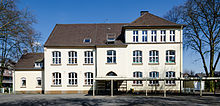
Dümpten (Oberhausen)

Dümpten is an old settlement site in the Ruhr area , in the course of industrialization partially Mülheim and partly Oberhausen has been assigned. The name Dümpten is derived from the term pond , which indicates the nature of the landscape, which used to be primarily agricultural and cultural. The northern part is now part of the Oberhausen district of Alt-Oberhausen , which had 7,946 inhabitants on December 31, 2018 and an area of around 1.63 km².
overview
After the establishment of the municipality of Oberhausen in 1862, the municipality of Dümpten - like the municipalities of Styrum and Alstaden - ceded the northern peripheral areas to Oberhausen in 1910. Allegedly, for the mayor of Mülheim at that time , the Dümpten around the colliery Roland, which was characterized by colony colony , was not suitable enough for Mülheim. Since the division of the Duisburg district in 1874, Dümpten belonged to the Mülheim district and from 1878 to the mayor's office of Styrum. After Oberhausen left the district of Mülheim as an independent town in 1901, as did the mayor's office of Mülheim, which was elevated to the status of town in 1904, the district of Mülheim only consisted of Dümpten, Alstaden and Heißen. In this context, Dümpten was raised to its own mayor's office, which only existed until the Mülheim district was dissolved in 1910. With the dissolution of the district, the northern part of the mayor's office of Dümpten was incorporated into the city of Oberhausen, the southern and Oberdümpten into the city of Mülheim.
The border of the former mayor's office at Dümpten ran (from west to east) along the Herder-, Hilgenberg, Straßburger-, Roland-, Wehr-, Mellinghofer- and a line south of the street Katzenbruch and the Kettwiger street to the Borbeck border. The boundaries of the statistical district of Dümpten, on the other hand, are quite different. Accordingly, the eastern part (east of Danziger Straße) is part of the statistical district of Schlad . This part forms together with Bermensfeld the municipal constituency 06 Vennepoth. In the north, parts of the Oberhausen old town between Mülheimer-, Schwartz-, Seiler- and Rolandstraße Dümpten have been slammed. As with other statistical districts of Oberhausen, the borders in Dümpten were drawn quite arbitrarily. The former Roland colliery was located in the district . Large parts of the former colliery area were converted into a park called "Stadtpark Rolandhalde".
statistics
As of December 31, 2018, 7,946 people lived in Oberhausen-Dümpten.
Structure of the population:
- Minor quota: 15.6% (Oberhausen average: 15.8%)
- Elderly rate: 22.1% (Oberhausen average: 21.6%)
- Proportion of foreigners: 12.9% (Oberhausen average: 15.4%)
- Unemployment rate: 7.5% (Oberhausen average: 7.8%)
Infrastructure

Dümpten is primarily a residential area. Towards the Mülheim border, the district is still largely agricultural. Dümpten is conveniently located north of the A40 motorway with the Mülheim-Dümpten driveway. The bus lines SB94, 124, 136, 143, 953, 956, 960, 961 and 976 of the Rhein-Ruhr transport association run through the district . In 1899, Dümpten was connected to the Mülheim tram. The line ran over Mellinghofer Strasse through Oberhausen-Dümpten to the Lipperheidebaum. Today the line is shut down from the mayor's office in Dümpten.
See also
Individual evidence
- ^ Oberhausen social structure report: Population on December 31, 2018
- ^ Heinz Reif: The belated city. Industrialization, urban space and politics in Oberhausen 1846 - 1929. Rheinland Verlag Cologne 1993, p. 16f
- ↑ memorandum to Hunderjahrfeier the city of Mülheim an der Ruhr 1908. ed. By the Historical Society Mülheim ad Ruhr. Julius Bagel Publishing House, Mülheim / Ruhr 1908, p. 113
- ^ Heinz Reif: The belated city. Industrialization, urban space and politics in Oberhausen 1846 - 1929 , Rheinland Verlag Cologne 1993, p. 17
- ↑ Election analysis of local elections 2009 (PDF; 855 kB)
- ^ Oberhausen social structure report: Proportion of the population under 18 years
- ^ Oberhausen social structure report: Proportion of the population aged 65 and over
- ^ Oberhausen social structure report: Proportion of non-German population
- ^ Oberhausen social structure report: Total unemployment rate in 2018
- ↑ Stadtlinienplan Oberhausen ( Memento of the original from June 17, 2012 in the Internet Archive ) Info: The archive link was inserted automatically and has not yet been checked. Please check the original and archive link according to the instructions and then remove this notice. (PDF; 2.9 MB)
- ↑ Otto-Ulrich Lange: 75 years of the Mülheim tram in: Yearbook Mülheim an der Ruhr 1973 , p. 90
Web links
- City map Dümpten (PDF; 4.6 MB)
Coordinates: 51 ° 28 ' N , 6 ° 52' E
