Acarí district
| Acarí district | |
|---|---|
 The Acarí district is located in the west of the Caravelí province (marked in red) |
|
| Basic data | |
| Country | Peru |
| region | Arequipa |
| province | Caravelí |
| Seat | Acari |
| surface | 770 km² |
| Residents | 5100 (2017) |
| density | 6.6 inhabitants per km² |
| founding | 1821 |
| ISO 3166-2 | PE-ARE |
| politics | |
| Alcalde District | Carlos Modesto Mejía Quispe (2019-2022) |
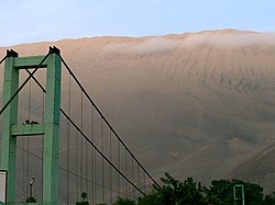
| Desert landscape near Acarí | |
Coordinates: 15 ° 26 ′ S , 74 ° 37 ′ W
The Acarí district is located in the Caravelí province in the Arequipa region in southwest Peru . The district was founded in 1821. It has an area of 770 km². The 2017 census counted 5100 inhabitants. In 1993 the population was 5127, in 2007 4019. The district administration is seated in the 163 m high town of Acarí with 3180 inhabitants (as of 2017). Acarí is located 140 km west-northwest of the provincial capital Caravelí .
Geographical location
The Acarí district is located in the west of the Caravelí province. The longitudinal extent in north-south direction is about 50 km. The Río Acarí flows through the district in a southerly direction. The area is almost entirely desert. Irrigated agriculture takes place only in the river valley of the Río Acarí. The district extends in the south up to 3 km to the Pacific coast . The national road 1S ( Panamericana ) runs along the southern district border.
The Acarí district is bordered to the west by the Bella Unión district , to the north by the Santa Lucía and San Pedro districts , to the northeast by the Sancos district (the three aforementioned districts are in the Lucanas province ), to the east by the Jaqui district and in Southeast to the Yauca district .
Web links
- Peru: Arequipa region (provinces and districts) at www.citypopulation.de
