Anra District
| Anra District | |
|---|---|
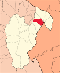
 Location of the district of Anra (marked in red) in the province of Huari |
|
| Basic data | |
| Country | Peru |
| region | Ancash |
| province | Huari |
| Seat | Anra |
| surface | 80.7 km² |
| Residents | 1472 (2017) |
| density | 18 inhabitants per km² |
| founding | December 24, 1982 |
| ISO 3166-2 | PE-ANC |
| politics | |
| Alcalde District | Deonicio de la Cruz Carrion (2019-2022) |
Coordinates: 9 ° 14 ′ 5 ″ S , 76 ° 55 ′ 35 ″ W.
The district of Anra is located in the province of Huari in the Ancash region in western Peru . The district was established on December 24, 1982. It has an area of 80.7 km². The 2017 census counted 1472 inhabitants. In 1993 the population was 2230, in 2007 it was 1800. The district administration is located in the 3172 m high village of Anra with 307 inhabitants (as of 2017). Anra is located 30 km east-northeast of the provincial capital Huari .
Geographical location
The district of Anra is located in the northeast of the province of Huari. The Río Puchca , left tributary of the Río Marañón , flows north along the northwestern district boundary.
The district of Anra borders in the southwest with the district Huacachi , in the northwest with the district Aczo ( province Antonio Raymondi ), in the north with the district Uco , in the northeast with the district Paucas , in the extreme east with the district Huacchis and in the southeast with the district Singa ( Huamalíes Province ).
Web links
- Peru: Region Ancash (provinces and districts) at www.citypopulation.de