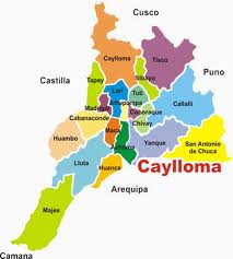
Chivay district
| Chivay district | |
|---|---|
 The district of Chivay (marked in light green) is centrally located in the province of Caylloma |
|
| Basic data | |
| Country | Peru |
| region | Arequipa |
| province | Caylloma |
| Seat | Chivay |
| surface | 242 km² |
| Residents | 5770 (2017) |
| density | 24 inhabitants per km² |
| ISO 3166-2 | PE-ARE |
| Website | municaylloma.gob.pe (Spanish) |
| politics | |
| Alcalde Provincial | Álvaro Cáceres Llica (2019-2022) |
| Political party | Arequipa Unidos por el Gran Cambio |
| Chivay city view | |
Coordinates: 15 ° 38 ′ S , 71 ° 36 ′ W
The Chivay district is located in the Caylloma Province in the Arequipa region in southwestern Peru . The district has an area of 242 km². The 2017 census counted 5770 inhabitants. In 1993, the population was 4,032, in 2007 the 6,532th The district administration is in the 3635 m high altitude provincial capital Chivay with 5,622 inhabitants (2017).
Geographical location
The Chivay district lies on the south bank of the Río Colca, which flows westward . Agriculture is practiced on terraces above the Colca Valley . There are several lookout points that overlook the gorge. These are frequented by tourists. The mountains in the south of the district are dry and barren. In the south of the district the ( 5425 m ) high Nevado Huarancate rises.
The district of Chivay borders in the south and southwest on the district Yanque , in the west on the district Coporaque , in the northwest on the district Tuti , in the extreme north on the district Sibayo and in the east on the district Callalli .
Individual evidence
- ↑ a b PERU: Arequipa region - provinces and districts . www.citypopulation.de. Retrieved May 7, 2020.
