Tapay District
| Tapay District | |
|---|---|
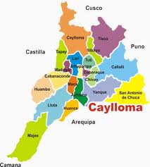
 The Tapay district (marked in light green) is located in the west of the Caylloma Province |
|
| Basic data | |
| Country | Peru |
| region | Arequipa |
| province | Caylloma |
| Seat | Tapay |
| surface | 414 km² |
| Residents | 772 (2017) |
| density | 1.9 inhabitants per km² |
| ISO 3166-2 | PE-ARE |
| politics | |
| Alcalde District | Concepción Gusmán Huacallo Tejada (2019-2022) |
| Political party | Alianza para el Progreso |
| Looking north over the Colca Gorge towards the Tapay district | |
Coordinates: 15 ° 35 ′ S , 71 ° 56 ′ W
The Tapay district is located in the Caylloma Province in the Arequipa region in southwestern Peru . The district has an area of 414 km². The 2017 census counted 772 residents. In 1993 the population was 820, in 2007 it was 671. The district administration is located in the 2975 m high village of Tapay with 64 inhabitants (as of 2017). Tapay is 37 km west-northwest of the provincial capital Chivay .
Geographical location
The Tapay district is located in the Cordillera Volcánica on the north bank of the Río Colca flowing west . The lengthwise extension in north-south direction is almost 40 km, the width is about 12 km. The main settlements are located above the Colca Gorge and can only be reached from the southern side of the valley via pedestrian suspension bridges. The western boundary of the district is the Río Molloco. The 5432 m high Sepregina lies on the eastern border of the district.
The Tapay district borders in the northeast on the Caylloma district , in the east on the Lari district , in the southeast on the Madrigal district , in the south on the Cabanaconde district and in the west on the Choco district ( Castilla province ).
Localities
There are the following localities (anexos) in the district:
- Cosñirhua - Malata
- Fure
- Juchuypuna
- Llatica
- Paclla
- San Juan de Chuccho
- Tocallo
Individual evidence
- ↑ a b PERU: Arequipa region - provinces and districts . www.citypopulation.de. Retrieved May 8, 2020.

