Tisco District
| Tisco District | |
|---|---|
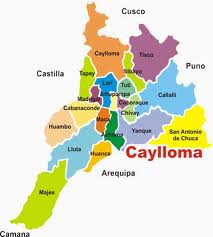
 The Tisco District (marked purple) is located in the extreme northeast of the Caylloma Province |
|
| Basic data | |
| Country | Peru |
| region | Arequipa |
| province | Caylloma |
| Seat | Tisco |
| surface | 1441 km² |
| Residents | 1441 (2017) |
| density | 1 inhabitant per km² |
| ISO 3166-2 | PE-ARE |
| politics | |
| Alcalde District | Nico Edgar Maque Colque (2019-2022) |
| Tisco | |
Coordinates: 15 ° 21 ′ S , 71 ° 27 ′ W
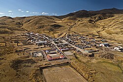
The Tisco District is located in the Caylloma Province in the Arequipa region in southwestern Peru . The district has an area of 1441 km². The 2017 census counted 1,441 inhabitants. In 1993 the population was 2287, in 2007 it was 1817. The district administration is located in the 4188 m high village of Tisco with 460 inhabitants (as of 2017). Tisco lies 36 km north-northeast of the provincial capital Chivay .
Geographical location
The Tisco district is located in the Cordillera Volcánica in the extreme northeast of the Caylloma Province. The Río Colca flows through the south of the district. It drains almost the entire area. In the northwest, the Río Apurímac flows a short distance along the district boundary to the north.
The district of Tisco borders in the southeast with the district Callalli , in the southwest with the district Sibayo , in the northwest with the district Caylloma , in the north with the districts Suyckutambo , Coporaque and Espinar (all three in the province Espinar ) and in the northeast with the districts Ocoruro and Condoroma (both in the province of Espinar).
Individual evidence
- ↑ a b PERU: Arequipa region - provinces and districts . www.citypopulation.de. Retrieved May 8, 2020.
